ENGRAVINGS & COLLECTIBLE MAPS // CARTOGRAPHY from DEMETRIUS SIATRAS
New Arrivals

SATIRICAL MAPS
by P.N. Soukakos
- Condition
- Brand new
- Jacket Condition
- Excellent
- Published
- 2005
- ISBN
- 9789604646906
- Quantity Available
- 1
- Seller
-
ATHENS, GRC
- Item Price
-
€88.00
Show Details
Description:
Bilingual (Greek-English) edition. Hard cover+dust jacket, net weight 1450 gr. ISBN: 9789604646906. Item Price
€88.00
Maps, Ports, Coastal Landscapes of Cefallonia and Ithaca - Under the Riggings of the Sea in Wind-Rose Lines
by Evridiki Livada-Duca
- Condition
- Brand new
- Published
- 2018
- ISBN
- 9789609832243
- Quantity Available
- 1
- Seller
-
ATHENS, GRC
- Item Price
-
€112.00
Show Details
Description:
Με τ' άρμενα της θάλασσας στα ρόδα των ανέμων - Χάρτες, Λιμάνια, Παραθαλάσσια τοπία Κεφαλλονιάς και Ιθάκης
Archive and Collection of Evridiki Livada-Duca. Limited edition of 500 numbered copies.
Argostoli, 2018. Bilingual Greek-English edition. Soft cover, 23x31 cm, 164 pp., ill.: reproductions of old maps and gravures; net weight 970 gr. It also includes two historical appendices: one on the siege… Read more about this item Item Price
€112.00

Louis-Francois Cassas and Cyprus: Engravings from the Bank of Cyprus Cultural Foundation Collections
by Louis-Francois Cassas
- Condition
- Brand new
- Published
- 2009
- Quantity Available
- 1
- Seller
-
ATHENS, GRC
- Item Price
-
€199.00
Show Details
Description:
Nicosia: Politistiko Hidryma Trapezes Kyprou, 2009. Brand new. Bilingual (greek-english) edition. Folio, 45 x 60 cm; contains six facsimiles of engravings by Louis-Francois Cassas, which are to be found in the Foundation’s collections and show views of Cyprus towns: Cyreneia, Larnaca, Famagusta, Bellapais and St. Hilarion.
Louis-Francois Cassas was a designer, engraver, sculptor and archeologist, who visited Cyprus twice,… Read more about this item Item Price
€199.00

Cyprus on the Table - Maps of Cyprus In British Government Papers 1878-1920
by Susan Gole
- Condition
- Brand new
- Published
- 1996
- ISBN
- 9789963420605
- Quantity Available
- 1
- Seller
-
ATHENS, GRC
- Item Price
-
€36.25
Show Details
Description:
In english. Soft cover, 30X22.5 cm, 64 pp., ill. Deals with all maps of Cyprus, manuscript and printed, to be found in both the British Parliamentary Papers and the Public Record Office. Available now to scholars is a full carto-bibliography of the maps of the island made by the British government from 1878 to 1920 (of which only printed ones… Read more about this item Item Price
€36.25
Maps of the Mediterranean Regions Published in British Parliamentary Papers 1801-1921
by Susan Gole
- Condition
- Brand new
- Published
- 1996
- ISBN
- 9789963420575
- Quantity Available
- 1
- Seller
-
ATHENS, GRC
- Item Price
-
€156.00
Show Details
Description:
Nicosia, 1996. Brand new. In English. Hard cover, 30X22.5 cm, 432 pp., ill.: 330 maps.
A large-format, illustrated and fully documented cartobibliography of all the maps of Mediterranean regions included in the British Parliamentary Papers between 1801 and 1921. Unlike the British Parliamentary Papers themselves, which have been the subject of exhaustive research and numerous publications, the maps included… Read more about this item Item Price
€156.00
Maps and Atlases, VOL. I
by Andreas Hadjipaschalis, Maria Iacovou
- Condition
- Brand new
- Published
- 1989
- Quantity Available
- 1
- Seller
-
ATHENS, GRC
- Item Price
-
€57.50
Show Details
Description:
Nicosia: Politistiko Hidryma Trapezes Kyprou , 1989. Brand new. Bilingual (greek-english) illustrated edition. Soft cover, 27 cm, 272 pp. Item Price
€57.50

Cyprus 1542 - The Great Map of the Island by Leonida Attar
by Francesca Cavazzana Romanelli & Gilles Grivaud
- Condition
- Brand new
- Published
- 2006
- ISBN
- 9789963428489
- Quantity Available
- 1
- Seller
-
ATHENS, GRC
- Item Price
-
€96.00
Show Details
Description:
In English. Soft cover book, 30X22.5 cm, 152 pp., ill.
The large scale map of Cyprus (139 x 64 cm), coloured using the aquarelle technique, was drawn up in 1542 by the Cypriot Leonidas Attar. Attar was appointed by the Venetian authorities as a specialist in irrigation works and military fortifications, which he undertook together with Michelle and Girolamo Sanmicheli in… Read more about this item Item Price
€96.00

The Evolution of the Sea Chart, from its Origin in the Mediterranean Sea to its Development by European Seamen into their Principal Instrument of Navigation
by Christopher Terrell
- Condition
- Brand new
- Published
- 1999
- ISBN
- 9789963420728
- Quantity Available
- 1
- Seller
-
ATHENS, GRC
- Item Price
-
€34.80
Show Details
Description:
Nicosia: Politistiko Hidryma Trapezes Kyprou, 1999. Brand new. In english. Soft cover, 30X22.5 cm, 48 pp., ill. Despite its great attraction for the layman, the development of the sea chart cannot be understood without reference to the progress achieved in the fields not only of cartography but also of mathematics, astronomy and instrument making. From the early… Read more about this item Item Price
€34.80
Vignettes in the Cartographic History of Cyprus
by Helen Wallis
- Condition
- Brand new
- Published
- 1992
- Quantity Available
- 1
- Seller
-
ATHENS, GRC
- Item Price
-
€33.00
Show Details
Description:
Nicosia: Politistiko Hidryma Trapezes Kyprou, 1992. Brand new. In english. Soft cover, 24 cm, 24 pp., ill. Item Price
€33.00
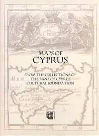
Maps of Cyprus - From the Collections of the Bank of Cyprus Cultural Foundation
by Leonora Navari (ed.)
- Condition
- Brand new
- Published
- 2003
- ISBN
- 9789963428182
- Quantity Available
- 1
- Seller
-
ATHENS, GRC
- Item Price
-
€109.00
Show Details
Description:
Nicosia, 2003. In English. Soft cover, 27 cm, 376 pp., ill.; net weight 1520 gr.
Includes 307 cartographic items, almost the whole of the maps in the Foundation's Collections. These come from (chiefly) the Map Collection: maps in the form of pamphlets and maps from early printed books such as isolaria and atlases; the Rare Publications Collection: maps from travellers', geography,… Read more about this item Item Price
€109.00

Mediterranean Cartographic Stories: Seventeenth - and Eighteenth-century
by P.N. Doukelles (ed.)
- Condition
- Brand new
- Published
- 2019
- ISBN
- 9786188304420
- Quantity Available
- 1
- Seller
-
ATHENS, GRC
- Item Price
-
€84.00
Show Details
Description:
Athens, 2019. Cloth, 24 cm, 176 pp. ISBN: 978-618-83044-2-0.
Contains papers presented at the 3rd International Conference of the Sylvia Ioannou Foundation (Nicosia, November 2016). The essays annotate three distinct manuscripts dating to the 17th and 18th centuries from the Foundation's Collection: an atlas from the famous cartographic workshop of Giovanni Battista Cavallini (Livorno 1635); a large-scale map of the Mediterranean… Read more about this item Item Price
€84.00

The History of the Cartography of Cyprus
by A. & J. Stylianou
- Condition
- Brand new
- Jacket Condition
- Excellent
- Published
- 1980
- Quantity Available
- 1
- Seller
-
ATHENS, GRC
- Item Price
-
€168.00
Show Details
Description:
In english. Hard cover+jacket, 25X34 cm, 452 pp., ill.
==============================================================
The shipping cost estimated by the system covers books weighing up to 750 gr.; a surcharge depending on the actual weight and destination applies for heavier books. Item Price
€168.00

He Peloponnesos - Chartographia kai historia: 16os-18os aionas
by Collective
- Condition
- Brand new
- Published
- 2006
- Quantity Available
- 1
- Seller
-
ATHENS, GRC
- Item Price
-
€54.22
Show Details
Description:
Athens: MIET, 2006. Brand new. In greek. Soft cover, 30x24 cm, 197 pp. Item Price
€54.22
Ta nesologia - He monaxia kai he syntrofia ton nesion
by Tolias, Giorgos
- Condition
- Brand new
- Published
- 2002
- Quantity Available
- 1
- Seller
-
ATHENS, GRC
- Item Price
-
€86.48
Show Details
Description:
Athens: Olkos, 2002. Brand new. In greek. Hard cover, 29 cm, 192 pp. Item Price
€86.48
The Greek Portolan Charts: 15th-17th Centuries - A Contribution to the Mediterranean Cartography of the Modern Period
by Tolias, Giorgos
- Condition
- Brand new
- Published
- 1999
- Quantity Available
- 1
- Seller
-
ATHENS, GRC
- Item Price
-
€68.04
Show Details
Description:
In English. Soft cover, 29x24 cm, 219 pp., ill. This elegant edition presents the manuscript maps of the Mediterranean Sea that were created by the Greeks during the 15th and the 17th century - an era of bloom for the Greek navigation and of expansion for the horizons of knowledge. This is the very first study and publication of these… Read more about this item Item Price
€68.04

To Ionio Pelagos - Chartographia kai historia: 16os-18os aionas
by Collective
- Condition
- Brand new
- Published
- 2007
- Quantity Available
- 1
- Seller
-
ATHENS, GRC
- Item Price
-
€69.00
Show Details
Description:
[ΙΟΝΙΑΝ SEA - CARTOGRAPHY AND HISTORY: 16th-18th Centuries]In greek. Soft cover, 30x24 cm, 245 pp., ill.: maps.
CONTENTS:
ΝΙΚΟΣ Ε. ΚΑΡΑΠΙΔΑΚΗΣ: ΤΑ ΕΠΤΑΝΗΣΑ ΑΠΟ ΤΟΝ 16ο ΕΩΣ ΤΟΝ 19ο ΑΙΩΝΑ
ΔΗΜΗΤΡΗΣ ΑΡΒΑΝΙΤΑΚΗΣ: Η ΒΕΝΕΤΙΚΗ ΚΥΡΙΑΡΧΙΑ ΣΤΟ ΙΟΝΙΟΟ ΚΑΤΑΛΟΓΟΣ ΤΗΣ ΕΚΘΕΣΗΣΗ ΤΑΥΤΟΤΗΤΑ ΤΟΥ ΙΟΝΙΟΥΕΝΟΤΗΤΑ Α: ΧΑΡΤΟΓΡΑΦΙΑ ΚΑΙ ΑΡΧΑΙΟΣ ΚΟΣΜΟΣΕΝΟΤΗΤΑ Β: Η ΕΠΟΧΗ ΤΩΝ ΑΤΛΑΝΤΩΝΕΝΟΤΗΤΑ Γ: Ο ΔΡΟΜΟΣ ΠΡΟΣ ΤΗΝ ΑΝΑΤΟΛΗΕΝΟΤΗΤΑ Δ: Η ΝΑΥΜΑΧΙΑ ΤΗΣ… Read more about this item Item Price
€69.00

AULETRIS
by R. Brendamoun (engraver)
- Condition
- Used - Very good
- Quantity Available
- 1
- Seller
-
ATHENS, GRC
- Item Price
-
€18.00
Show Details
Description:
Very good. Wood engraving, 29x42 cm, printed in Leipzig, 1892 Item Price
€18.00
Maps and Mapmakers of the Aegean
by Collective
- Condition
- Brand new
- Published
- 1985
- Quantity Available
- 1
- Seller
-
ATHENS, GRC
- Item Price
-
€85.07
Show Details
Description:
Athens: Olkos, 1985. Brand new. Clothbound, 29x22 cm, 263 pp., ill. The charting of the Aegean Sea from the 15th up to the 19th century with rare maps and texts by Anna Avramea, S. Asdrachas and V. Sfyroeras. Item Price
€85.07
Isolario: Solitude and Company of the Islands
by G. Tolias, Sp. Asdrachas
- Condition
- Brand new
- Published
- 1985
- Quantity Available
- 1
- Seller
-
ATHENS, GRC
- Item Price
-
€90.02
Show Details
Description:
Athens: Olkos, 1985. Brand new. Hard cover, 29 cm, 196 pp., 130 color plates. The volume is dedicated to the old manuscript or printed collection of island maps, the isolarii. These rare works, kept in the collections of European and American libraries and museums, are published for the first time. The edition illustrates the composite role of the… Read more about this item Item Price
€90.02
Eastern Mediterranean Cartographies
by G. Tolias, D. Loupis (eds.)
- Condition
- Brand new
- Published
- 2004
- ISBN
- 9781105084522
- Quantity Available
- 1
- Seller
-
ATHENS, GRC
- Item Price
-
€72.00
Show Details
Description:
Athens: National Hellenic Research Foundation, 2004. Brand new. Multilingual (en-fr-gr) edition; Proceedings of the International Conference on the History of cartography, Athens, 1999; soft cover, net weight 880 gr., 24 cm, 402 pp. ISSN 1105-0845-25/26. Item Price
€72.00
