E. Books--Atlases from The Prime Meridian: Antique Maps & Books
New Arrivals

Atlas of Israel, Cartography Physical and Human Geography
by The Survey of Israel (multiauthored atlas)
- Condition
- As New
- Jacket Condition
- No Jacket
- Edition
- 3rd
- Published
- 1985
- Binding
- Hardcover
- Quantity Available
- 1
- Seller
-
Crozet, Virginia, USA
- Item Price
-
€141.38
Show Details
Description:
New York: MacMillan Publishing Company, 1985. As new. This is the third edition (the most recent), with 40 printed color plates (numbered), in collaboration with The Survey of Israel (Tel Aviv). The first edition, published c. 1964, dealt with Israel within the 1949 armistice lines. The second edition (1970) covered the post-cease fire lines from 1967. This edition, beautifully produced,… Read more about this item Item Price
€141.38
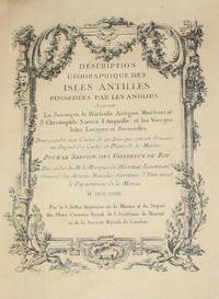
(History of Cartography, Geographic description of the Antilles): Description geographique des isles Antilles possédées par les Anglois
by Bellin, Jacques Nicolas
- Condition
- Used - Very Good
- Edition
- First Edition
- Published
- 1758
- Binding
- Hardcover
- Quantity Available
- 1
- Seller
-
Crozet, Virginia, USA
- Item Price
-
€7,139.44
Show Details
Description:
A Paris: De l'imprimerie de Didot, 1758. This 10.5 inch quarto is in very good condition, sound hinges, 171 pp. with all 22 maps (several folding), plans and views in very good or better condition on heavy paper. Contemporary calf boards with original marbeled pastedowns, two title pages (one decorative with attribution to Bellin), "Tables des Titres" and "Table… Read more about this item Item Price
€7,139.44
(Thematic Maps): Statistical Atlas of the United States, Eleventh Census
by Gannett, Henry
- Condition
- Used - Very Good
- Jacket Condition
- No Jacket
- Published
- 1898
- Binding
- Hardcover
- Quantity Available
- 1
- Seller
-
Crozet, Virginia, USA
- Item Price
-
€706.88
Show Details
Description:
Washington (DC): Deptartment of the Interior, 1898. Twenty-one inch elephant folio, original endpapers and pebbled cloth boards scuffed.. Binding reasonably sound, internally very good, complete (69 pp.). Reference: Phillips, Maps, 945. Rumsey list no. 1873b. 63 numbered, colored plates, very little foxing and no staining. At head of title: Department of the interior, Census office. Robert P. Porter, superintendent ...… Read more about this item Item Price
€706.88
(Maps, Western Canada): Index to Captain Palliser's Reports, showing the date of each journey, the route, and the page in which it is described in the copies of the reports laid before Parliament on the 19th May 1863
by Palliser, John
- Condition
- Used - Very Good
- Edition
- First Edition Thus
- Published
- 1865
- Binding
- Paperback
- Quantity Available
- 1
- Seller
-
Crozet, Virginia, USA
- Item Price
-
€3,652.19
Show Details
Description:
London: Printed by George Edward Eyre and William Spottiswode, Printers to the Queen's Most Excellent Majesty, for Her Majesty's Stationery Office., 1865. This is just the index with the five folding maps, all in very good or better condition. The bluish-green paper covers are nearly separated at the spine, but generally clean and legible. There is a handwritten signature of… Read more about this item Item Price
€3,652.19
The Shape of the World: The Mapping and Discovery of the Earth
by Berthon, S. and Robinson, A
- Condition
- Used
- Quantity Available
- 1
- Seller
-
Crozet, Virginia, USA
- Item Price
-
€23.56
Show Details
Description:
George Philip Ltd., London, 1991. As new w/minimal chipping to dust cover edge due to storage. 4vo., this is the companion volume to Britain's Granada Televion series of the same name. Many beautiful color map reproductions, including sattelite images, dating from the earliest crud e maps to pictures taken from Apollo 8 in 1968. Endpapers are reproductions from major… Read more about this item Item Price
€23.56
(History, Cartography): Lavoisne's Complete Genealogical, Historical, Chronological, and Geographical Atlas; A General Guide to History, Both Ancient and Modern..according to the plan of Le Sage, Greatly Improved. A New Edition, Enlarged
by Gros, C. And Aspin, J
- Condition
- Used - Very Good
- Edition
- First Thus
- Published
- 1814
- Binding
- Hardcover
- Quantity Available
- 1
- Seller
-
Crozet, Virginia, USA
- Item Price
-
€1,979.25
Show Details
Description:
London: J. Barfield (Wardour-Street), 1814. Eighteen inch, half leather, elephant folio, with original boards and embossed label, expertly rebacked with deep red Harmattan leather with new leather at corners, 22k gold tooled leather spine. Original endpapers, title page, and dedication page to Prince Charlotte of Wales. All 64 engraved maps and charts present, with minimal browning/foxing, and original hand color.… Read more about this item Item Price
€1,979.25
(Military Atlas- Thematic Maps, Charts, Letters, Crests): Atlas to the Memoirs of John Duke of Marlborough Containing Armorial Bearings, Fac Similes, Maps, and Military Plans
by Marlborough, John (Duke of Marlborough)
- Condition
- Used - Very Good
- Edition
- First Edition
- Published
- 1820
- Binding
- Hardcover
- Quantity Available
- 1
- Seller
-
Crozet, Virginia, USA
- Item Price
-
€801.12
Show Details
Description:
London: Longman, Hurst, Rees, Orme and Brown (Paternoster-Row), 1820. Large 11 inch 4to., with attractive contemporary half-leather, marbeled paper boards, gilt lettered spine; binding tight. Newer endpapers, mild offsetting to verso of a few plates, mild foxing a few plates. All 22 maps / plans / charts / armorial crests and facsimile documents are in very good condition. Battle… Read more about this item Item Price
€801.12
(Thematic Atlas- Revolutionary War Maps): The Atlas of Congressional Roll Calls for the Continental Congresses 1777-1781
by Lord, Clifford L
- Condition
- Used - Very Good
- Jacket Condition
- No Jacket
- Published
- 1943
- Binding
- Hardcover
- Quantity Available
- 1
- Seller
-
Crozet, Virginia, USA
- Item Price
-
€164.94
Show Details
Description:
Cooperstown: New York State Historical Association, 1943. VG, slightly bowed, usual library markings. An uncommon analysis of the voting of the Continental Congresses during the Revolutionary War era. Over 500 small b&w map plates with applicable information (very small print), detailing all votes and regional variations. Errata slip bound in. Lord had extensive experience in the production of US historical… Read more about this item Item Price
€164.94
Lewis Evans...To Which is Added Evans' A Brief Account of Pennsylvania
by Gipson, Lawrence Henry
- Condition
- Used - Very Good
- Jacket Condition
- No Jacket
- Published
- 1939
- Binding
- Hardcover
- Quantity Available
- 1
- Seller
-
Crozet, Virginia, USA
- Item Price
-
€141.38
Show Details
Description:
Philadelphia: The Historical Society of Pennsylvania, 1939. VG copy of this excellent work. Has 5 facsimle maps: A Map of the Indian walking Purchase, A Map of Pennsylvania, New Jersey, New York..., A Revision of the 1752 Edition of this foregoing Map of 1749, Evans'[ Map of the Middle Atlantic Region..for Peter Kalm..., A Map of the Area in dispute… Read more about this item Item Price
€141.38
(2 Volume Set- Prussian Military History, with 6 Articles and Complete 25 Map Case with Explanatory Volume): Prussian Manuals for Military Fortifications, with Complete Atlas Case
by Lennox (General Sir Wilbraham Oates)
- Condition
- Used - Very Good
- Published
- 1880
- Binding
- Hardcover
- Quantity Available
- 1
- Seller
-
Crozet, Virginia, USA
- Item Price
-
€1,178.12
Show Details
Description:
Royal Engineers , 1880. Virtually unique as presented here, apparently intended as a private publication for the Royal Corps of Engineers, with all 6 articles (Proposed Prussian Organization for the Duties of Troops at Sieges translated by HE Rawson, 26; Prussian Sapping Regulation translated by HA Gun, 40pp; Prussian Etappen Regulations, translated by D O'Brien, 72pp; Elements of Fortress Warfare,… Read more about this item Item Price
€1,178.12
(Thematic Maps): Oceanographic Atlas of the Pacific Ocean
by Barkley, Richard A
- Condition
- Used - Very Good
- Edition
- First Edition
- Published
- 1968
- Quantity Available
- 1
- Seller
-
Crozet, Virginia, USA
- Item Price
-
€75.40
Show Details
Description:
Honolulu: University of Hawaii Press, 1968. Interior fine. Minimal scuffing and rubbing to the boards. Oblong elephant folio. Extensive thematic maps of Pacific Ocean, with data on weather , water salinity, submarine configuration, etc. This particular atlas is inscribed by the author, to his mother, with a signed brochure (again to his mother) advertising the publication. Detailed references, data sources… Read more about this item Item Price
€75.40
(History of Cartography): Historical Atlas of the Pacific Northwest
by Hayes, Derek
- Condition
- As New
- Jacket Condition
- As New
- Edition
- First Edition
- Published
- 1999
- Binding
- Hardcover
- Quantity Available
- 1
- Seller
-
Crozet, Virginia, USA
- Item Price
-
€37.70
Show Details
Description:
Seattle: Sasquatch Books, 1999. As new copy of the first edition this wonderful recent production, already increasingly difficult to find. Hard to beat this quality for the price. This has already received rave reviews from several sources, and reproduces 320 maps over four centuries (ranging from Sir Francis Drake's 1579 voyages through the Klondike goldrush and Canadian Pacific Railways maps/surveys).… Read more about this item Item Price
€37.70
(Military History: all 12 maps & plans): Memoires De Mr. Le Marquis De Feuquiere, Lieutenant - General Des Armees Du Roi: Contenans ses Maximes sur la Guerre...Nouvelle Edition
by Marquis De Feuquiere, Mr. Le Marquis (Antoine)
- Condition
- Used - Very Good
- Published
- 1741
- Quantity Available
- 1
- Seller
-
Crozet, Virginia, USA
- Item Price
-
€928.36
Show Details
Description:
Amsterdam: Francois L'Honore et Filacharie Chatelain, 1741. This is the new and corrected edition (the first edition was published in 1711, with mulitple subsequent issuances, inlcuding the new edition listed here. A number of copies may be seen in the online KVK catalogue. Quarto, 10.5 inches, with contemporary marblelled boards (few scuffs and scrapes), quarter vellum with spine labeling disctinct… Read more about this item Item Price
€928.36
Civil War Atlas to Accompany Steele's American Campaigns
by Stamps, TD (editor)
- Condition
- Used
- Edition
- First Edition
- Published
- 1941
- Quantity Available
- 1
- Seller
-
Crozet, Virginia, USA
- Item Price
-
€84.82
Show Details
Description:
West Point : US Military Academy (Dept. Of Military Art and Engineering), 1941. Oblong atlas elephant folio (13x19 inches). All 136 maps in near fine condition, with original outline color. THis atlas was prepared by the US Military Academy for its course in military history. The only flaw is that the previous owner stored this folded, so there is a… Read more about this item Item Price
€84.82
(Military Atlas- Thematic Maps, Charts, Letters, Crests): Atlas to the Memoirs of John Duke of Marlborough Containing Maps and Plans Illustrative of the Campaigns, Fac-Simile Autographs, Armorial Bearings, etc
by Marlborough, John (Duke of Marlborough)
- Condition
- Used - Very Good
- Edition
- First Thus
- Published
- 1865
- Binding
- Hardcover
- Quantity Available
- 1
- Seller
-
Crozet, Virginia, USA
- Item Price
-
€372.29
Show Details
Description:
London: Bell and Daldy, 1865. Large 4to., original cloth covres a bit scuffedand rubbed, with small stain right upper front cover, but binding tight. Owner signature (E. Wyatt Dane) front endpaper, date 1899 from Trinity College. All 26 maps / plans / charts / armorial crests and facsimile documents are in excellent condition with little browning or foxing. Battle… Read more about this item Item Price
€372.29
Britannica Atlas
by Encyclopedia Britannica, Inc
- Condition
- Used
- Quantity Available
- 1
- Seller
-
Crozet, Virginia, USA
- Item Price
-
€42.41
Show Details
Description:
Encyclopedia Britannica Inc., Chicago, 1977. Nice 4vo world atlas. No Dj, cover G due to soiling and some wear. Most of maps VG+. 312pp maps; 222pp index. Some soiling edges.. Item Price
€42.41
(Civil War Atlas- 22 Battle & Campaign Maps): History of the Army of the Cumberland...Atlas (Atlas Only)
by Ruger, Edward (by the request of Major-General George Thomas)
- Condition
- Used
- Published
- 1875
- Binding
- Hardcover
- Quantity Available
- 1
- Seller
-
Crozet, Virginia, USA
- Item Price
-
€466.54
Show Details
Description:
Cincinnati: Robert Clarke & Co., 1875. Large 8vo. with very few markings; tiny bookseller sticker at lower end of rear paste-down; some scuffing to spine, but text legible and binding tight. Exterior very good, internally about fine. All 22 maps (many folding out too much larger size) present, and color coded for troop positions: Map...Operations...Armies...Cumberland and Ohio...Generals Anderson, Sherman, and… Read more about this item Item Price
€466.54
(Maps of Washington): Geological Atlas of the United States, Ellensburg Folio, Washington
by Walcott, Charles D (General Text); Smith, George O (Text on Ellensburg Quadrangle)
- Condition
- Used
- Quantity Available
- 1
- Seller
-
Crozet, Virginia, USA
- Item Price
-
€47.12
Show Details
Description:
US Geological Survey, Washington DC, 1903 (Ellensburg Folio, No. 86). Folio,G due to dampstaining margins of text and maps (color images themselves in excellent condition). Some chipping margins of softcover and text pages (no loss of text). There is an explanation of relavent general geological information by CD Walc ott, with the more specific details of the region written… Read more about this item Item Price
€47.12
(Military History, Siege Warfare, Engineering- all 36 plates): De L'Attaque et De La Defense Des Places:..Marechal De France & Directeur General Des Fortifications Du Royaume
by Vauban, Mr. de (Sebastien Le Pestre; Marshal of France)
- Condition
- Used
- Edition
- First Edition
- Published
- 1737
- Binding
- Hardcover
- Quantity Available
- 1
- Seller
-
Crozet, Virginia, USA
- Item Price
-
€1,413.75
Show Details
Description:
Paris: Pierre De Hondt (A La Haye), 1737. Large 4to. full leather, covers a bit chipped at upper corners, hinges starting, ornamental 5-banded spine with gilt-lettering. All 36 plates detailing fortifications are present, most in very good or better condition. Plate 26 a bit chipped at outer edge where it extends beyond the margins. A few scattered library stamps, not… Read more about this item Item Price
€1,413.75
(39 Maps / City Plans): An Illustrated Atlas, Geographical Statistical, and Historical, of the United States, and the adjacent Countries
by Bradford, T.G. (Thomas Gamaliel)
- Condition
- Used
- Edition
- First Thus
- Published
- 1838
- Quantity Available
- 1
- Seller
-
Crozet, Virginia, USA
- Item Price
-
€7,799.19
Show Details
Description:
Boston & New York: Weeks, Jordan & Co., and Wiley & Putnam, 1838. Twenty inch elephant folio, expertly re-backed with original half-leather boards, with original spine laid down on a new Harmatan goatskin spine, some restoration to corners of covers. Front endpapers creased (original), with two title pages (first in full color). Few maps expertly repaired verso (minor tears at… Read more about this item Item Price
€7,799.19
