B. Maps--US & N. America from The Prime Meridian: Antique Maps & Books
New Arrivals

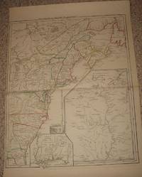
(Railroad History): Map of the Pennsylvania Rail Road, from Harrisburg to Pittsburg; and of the Columbia & Lancaster & Harrisburg R.R.s from Philadelphia to Harrisburg
by Haupt, H. (Herman)
- Condition
- Used - Very Good
- Edition
- First Edition Thus
- Published
- 1855
- Binding
- Paperback
- Quantity Available
- 1
- Seller
-
Crozet, Virginia, USA
- Item Price
-
€937.79
Show Details
Description:
Philadelphia: T.K. and P.G. Collins, Printers, 1855. Map with folds as issued, original hand coloring, with a couple of chips at edges but overall in very good condition and image clear. The long, folding image measures roughly 20 x 178 cm. (8 x 70 inches). This is in the original stiff paper covers (9 x 6 inches), titled "Guide for… Read more about this item Item Price
€937.79
[Revised Facsimile, Washington, DC]: Plan of the City Intended for the Permanent Seat of the Government of the United States
by L'Enfant, Pierre Charles
- Condition
- Used - Very Good
- Published
- 1976
- Quantity Available
- 1
- Seller
-
Crozet, Virginia, USA
- Item Price
-
€362.86
Show Details
Description:
Washington (DC): U.S. Coast and Geodetic Survey, 1976. L'Enfant's original landmark plan of August 1791 was copied and reproduced in 1887 by the U.S. Coast & Geodetic Survey. According to F.M. Thorn's (Superintendent) note on the map, this reproduction "...is as nearly complete and exact as trained skill, care, and the use of the best appliances can make it; that… Read more about this item Item Price
€362.86

(Map of colonial northeastern Canada): Partie Orientale de la Nouvelle France ou du Canada...Terre-Neuve...Nouvelle Ecosse Acadie...T. Conrad Lotter Graveur et Geogr
by Lotter, Conrad (Seutter, Albrecht Carl)
- Condition
- Used
- Published
- 1756
- Quantity Available
- 1
- Seller
-
Crozet, Virginia, USA
- Item Price
-
€1,786.04
Show Details
Description:
Augusburg: Tobias Conrad Lotter and Albrecht Karl Seutter, 1756. Very good copperplate engraving with a right marginal tear not affecting image, repaired verso with archival tape. Some restoration to left margin (not affecting main image), and entire map backed with archival paper. Strong image. Small embossed stamp left lower margin (faint), with attribution to Seutter in left lower margin just… Read more about this item Item Price
€1,786.04
(Map of Aspen District, Colorado- 2 Map Geological Set): Aspen Mountain (Sheets XXV & XXVI)
by Spurr, Josiah Edward (lithography by Julius Bien & Co
- Condition
- Used
- Published
- 1898
- Quantity Available
- 1
- Seller
-
Crozet, Virginia, USA
- Item Price
-
€216.78
Show Details
Description:
Washington DC: Dept. of the Interior, United States Geological Survey, 1898. Near fine pair of geology sheets with original printed color (quite decorative), from an 1891 survey. Very detailed, with a small view of Aspen mountain central to map. Major mining shafts shown, with major fault lines and color coding of applicable mineral resources. Small expanse of Colorado Midland… Read more about this item Item Price
€216.78
(Map of early USA): Etats-Unis de L'Amerique Septentrionale Avec Les Isles Royal, de Terre Neuve, de St. Jean, L'Acadie &c
by Delamarche [Charles Francois]
- Condition
- Used
- Published
- 1785
- Quantity Available
- 1
- Seller
-
Crozet, Virginia, USA
- Item Price
-
€1,767.19
Show Details
Description:
Paris, 1785. Very good condition, early outline hand color, nice margins, published when Delamarche was at "Rue du Foin St. Jacques au College de Mtre. Gervais." Minimal foxing and marginal browning. The main focus of the map is east of the Mississippi River, and includes southeastern Canada. There is a table of the post-revolutionary war states and respective capitols in… Read more about this item Item Price
€1,767.19
(Maps, Western Canada): Index to Captain Palliser's Reports, showing the date of each journey, the route, and the page in which it is described in the copies of the reports laid before Parliament on the 19th May 1863
by Palliser, John
- Condition
- Used - Very Good
- Edition
- First Edition Thus
- Published
- 1865
- Binding
- Paperback
- Quantity Available
- 1
- Seller
-
Crozet, Virginia, USA
- Item Price
-
€3,652.19
Show Details
Description:
London: Printed by George Edward Eyre and William Spottiswode, Printers to the Queen's Most Excellent Majesty, for Her Majesty's Stationery Office., 1865. This is just the index with the five folding maps, all in very good or better condition. The bluish-green paper covers are nearly separated at the spine, but generally clean and legible. There is a handwritten signature of… Read more about this item Item Price
€3,652.19
(Map, Revolutionary War Era, Colonial America): Theatre de la Guerre en Amerique
by Le Rouge, George Louis
- Condition
- Used - Very Good
- Published
- 1777
- Quantity Available
- 1
- Seller
-
Crozet, Virginia, USA
- Item Price
-
€3,393.00
Show Details
Description:
Paris: le Rouge, 1777. Very good/excellent, hand colored outlines, trimmed a bit close at margin (due to binding in prior Le Rouge atlas, "Atlas Ameriquain Septentrional..."). Image measuring 62 x 50 cm (24 x 20 inches). This is a clean impression on heavy paper. Three insets: Louisiane, southeast coastal region (Floride), Sault du Niagra. "Par le Sr. le Rouge, ingenieur… Read more about this item Item Price
€3,393.00
(Revolutionary War Era): A map of the inhabited part of Canada from the French surveys; wiith the frontiers of New York and New England from the large surveys
by Sauthier, Claude Joseph
- Condition
- Used - Very Good
- Edition
- First Edition Thus
- Published
- 1777
- Quantity Available
- 1
- Seller
-
Crozet, Virginia, USA
- Item Price
-
€3,581.50
Show Details
Description:
London: Wm. Faden, 1777. Very good, minimal wash color as issued, with remarks indicating the survey order of Genr. Pownall. This uncommon map relates to the invasion of Canada. A few small archival taped repairs in margin verso. Heavy paper, very ittle browning This is the later state (2nd), with the dedication to Major General John Burgoyne, and the table… Read more about this item Item Price
€3,581.50
(History of Cartography): Lewis Evans His Map of the Middle British Colonies in America: A Comparative Account of Ten Different Editions Published Between 1755 and 1807
by Stevens, Henry N
- Condition
- Used - Very Good
- Edition
- First Edition
- Published
- 1905
- Binding
- Paperback
- Quantity Available
- 1
- Seller
-
Crozet, Virginia, USA
- Item Price
-
€353.44
Show Details
Description:
London: Henry Stevens, Son and Stiles, 39 Great Russell Street Over Against the South-West Corner of the British Museum, 1905. Overall very good copy in original stiff paper boards, with Chiswick Press colophon towards rear of book. 41 pp., 8.75 inch octavo, with some chipping to edge of upper spine. Covers minimally soiled. This small reference monograph is increasingly difficult… Read more about this item Item Price
€353.44
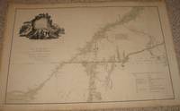
(Map/Chart NE Coast USA, New England): Carte réduite des côtes orientales de l'Amérique septentrionale. Contenant celles des provinces de New-York et de la Nouvelle Angleterre, celles de l'Acadie ou Nouvelle Ecosse, de I'&I
by Sartine (Antoine de, comte d'Alby)
- Condition
- Used
- Published
- 1780
- Quantity Available
- 1
- Seller
-
Crozet, Virginia, USA
- Item Price
-
€4,241.25
Show Details
Description:
Paris: Dépôt des cartes et plans de la Marine, 1780. Near fine, large, striking chart of New England area, from the French Hydrographic Office of the time. Early hand color, No. 163 on upper right corner, "Petit Sculp." lower left, "Prix Trois Francs" lower right. The paper is heavy and clean, with nice margins, and the impression is very clear.… Read more about this item Item Price
€4,241.25
(History, Cartography, Canada): Plans of the First Frech Settlements on the Saint Lawrence 1635-1642
by Bourdon, Jehan
- Condition
- Used - Very Good
- Edition
- Facsimile, Limited
- Published
- 1958
- Binding
- Paperback
- Quantity Available
- 1
- Seller
-
Crozet, Virginia, USA
- Item Price
-
€329.88
Show Details
Description:
Montreal: McGill University Library , 1958. This facsimile production was limited to 250 copies, and the 9 folding sheets with 10 plans are in their original 17-inch folio paper wrap. Bourdon wore many hats during his life, and these plans were drawn while he was Surveyor-General of Quebec. These plans are "without a doubt the earliest Canadian maps to survive..".… Read more about this item Item Price
€329.88
(Travel Book, Folding Map of USA): The Illustrated Hand - Book, A New Guide for Travelers Through the United States of America..Railroad, Stage and Steamboat Routes..Accompanied By a Large and Accurate Map
by Smith, J. Calvin
- Condition
- Used
- Published
- 1849
- Quantity Available
- 1
- Seller
-
Crozet, Virginia, USA
- Item Price
-
€1,366.62
Show Details
Description:
New York: Sherman & Smith , 1849. Green cloth, decorative gilt embossed cloth boards rubbed and scuffed with some staining and sunning, but binding is sound. All 80 pp. text is present (with elaborate place-names and distance tables), in very good condition with minimal browning. The copyright date is 1846. Original endpapers present and browned (more than text). The large… Read more about this item Item Price
€1,366.62
(Map of Spain and Portugal): Les Royaumes D'Espagne et de Portugal
by Bonne, Rigobert
- Condition
- Used
- Published
- 1780
- Quantity Available
- 1
- Seller
-
Crozet, Virginia, USA
- Item Price
-
€70.69
Show Details
Description:
Geneva, 1780. VG, b&w as issued. There are one or two minor stains, not causing any serious visual distractions. Majorca (with Balearic Islands) is shown. There are 4 scales. This is from "Atlas de Toutes Les Parties Connues du Globe Terrestre...". The image mea sures 21x32cm (8.25x12.5 inches). The date is approximate.. Item Price
€70.69
(Map of Gulf of Mexico and Environs- 2 Map Set): L'Ancien et Le Nouveau Mexique, Avec La Floride et La Basse Louisiane...(Eastern and Western plates)
by Bonne, Rigobert (with Desmarest)
- Condition
- Used
- Published
- 1788
- Quantity Available
- 1
- Seller
-
Crozet, Virginia, USA
- Item Price
-
€400.56
Show Details
Description:
Paris: Hotel De Thou, Rue Des Poitevins, 1788. VG+, b&w as issued, copperplate on heavy paper. A very nice pair of images from "Atlas Encyclopedique...", done by Bonne and Desmarest and published in two volumes in 1787-88. A somewhat unusual set of views (eastern and western plates) of the environs of the Gulf of Mexico, with detail of Central America… Read more about this item Item Price
€400.56
(Map of Future USA, Canada): Canada IIe
by unknown
- Condition
- Used
- Published
- 1750
- Quantity Available
- 1
- Seller
-
Crozet, Virginia, USA
- Item Price
-
€518.38
Show Details
Description:
Amsterdam: La Feuille (?), 1750. VG+ w/hand colored outlines. 5 separate scales (Echelle). This French map gives native american tribal locations in some detail, which was a frequent occurence in maps of this type and time. Most of main image is labelled as Canada, with a nice view of the Great Lakes. The Colonies are labelled, with no state borders… Read more about this item Item Price
€518.38
(Map of midatlantic and southeast USA): Middle States
by Olney, J
- Condition
- Used
- Quantity Available
- 1
- Seller
-
Crozet, Virginia, USA
- Item Price
-
€84.82
Show Details
Description:
Robinson Pratt & Co., NY, c. 1837. VG w/ full hand-coloring. Copperplate. Shows New York, Pennsylvania, Maryland, Delaware, most of Virginia and part of North carolina. Detailed. From "New and Improved Schooll Atlas, to accompany the Practical System of Modern Geography." Area from L ake Ontario to Pamlico Sound. Population demographics, topography, waterways. 42x25cm.. Item Price
€84.82
(manuscript map- North America): Untitled
by unknown
- Condition
- Used
- Published
- 1895
- Quantity Available
- 1
- Seller
-
Crozet, Virginia, USA
- Item Price
-
€268.61
Show Details
Description:
Unknown: Unknown, 1895. Late 19th century manuscript map (date approximate), with some handwritten reference to George Philip (sic) & Son on verso. Orginal hand coloring with some general browning. The is a tablular index, numerically coded for the USA. Some of the larger states (for example Texas, Arizona, New Mexico, Arizona- more names of western states directly on the image)… Read more about this item Item Price
€268.61
(Map of Virginia-- Civil War, Second Manassas): Map of Route and Positions of First Corp, Army of Va., Maj. Gen. Sigel, Comg., From July 7th to Septr. 10th 1862
by Pope, Major General John (Major Franz Kappner, Chief of Engineers)
- Condition
- Used
- Edition
- First Edition
- Published
- 1863
- Quantity Available
- 1
- Seller
-
Crozet, Virginia, USA
- Item Price
-
€400.56
Show Details
Description:
Washington (DC): House of Representatives, 1863. VG with minor fold browning and 1 or 2 small crease tears at fold junctions. A large map showing the First Corps' route from Middletown, Va. to the defenses of Washington, DC. Names of individual residents are listed along the march line. Much more detail than might be apparent from initial visual inspection of… Read more about this item Item Price
€400.56
(Linen Backed Wall Map - Social Sciences; USA, Land Acquisition, Expansion): A10 Westward Movement
by Hart, Albert Bushnell
- Condition
- Used
- Published
- 1951
- Quantity Available
- 1
- Seller
-
Crozet, Virginia, USA
- Item Price
-
€141.38
Show Details
Description:
Chicago (5235 Ravenswood Ave.): Denoyer-Geppert Company , 1951. Near fine 32x44 inch linen backed wall map with original printed color and gromets, folding into the original 12x10 inch cloth boards with label. Denoyer-Geppert was a major producer of maps of history and science from about 1930 to 1950, and the original list of publications is pasted inside the front cloth… Read more about this item Item Price
€141.38
(Map of Maryland): Maryland
by Finley, A. (Young & Delleker, Sc.)
- Condition
- Used
- Published
- 1829
- Quantity Available
- 1
- Seller
-
Crozet, Virginia, USA
- Item Price
-
€174.36
Show Details
Description:
Philadelphia: A. Finley, 1829. Fine w/minimal browning, fully hand-colored. More detailed than similar version a few years earlier. From "A new General Atlas..of the Globe". Roads, towns, counties, topography. 22x28.5cm.. Item Price
€174.36
