Maps from Asia Bookroom
New Arrivals

More Photos
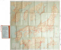
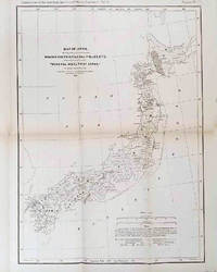
Travelers' Map of Japan, Chosen (Korea), Taiwan (Formosa), with Brief Descriptions of the Principal Tourist Points in Japan.
by [1920S TOURIST MAP - JAPAN, KOREA AND TAIWAN].
- Condition
- Used
- Published
- 1925.
- Quantity Available
- 1
- Seller
-
Canberra, Australian Capital Territory, AUS
- Item Price
-
€325.55
Show Details
Description:
[Tokyo].: Japanese Government Railways.. 1925.. Large folding colour map, 78.5 x 80 cm, of Japan and Korea, Six inset maps one of which shows Taiwan; tipped into the original green cloth covered case with green ties, the cloth a little faded, decorative title-page and text in 30 panels on the verso, a very good, clean copy. Scarce edition of… Read more about this item Item Price
€325.55
![台灣省地圖. [Taiwansheng ditu]. [Map of Taiwan Province].](https://d3525k1ryd2155.cloudfront.net/h/429/688/1600688429.0.m.jpg)
台灣省地圖. [Taiwansheng ditu]. [Map of Taiwan Province].
by [TAIWAN PROVINCE MAP].
- Condition
- Used
- Edition
- Reprint.
- Published
- 1954.
- Quantity Available
- 1
- Seller
-
Canberra, Australian Capital Territory, AUS
- Item Price
-
€232.54
Show Details
Description:
地圖出版社.. Reprint.. 1954.. Colour folding map of Taiwan showing all major cities, towns and villages, railways, highways, roads, rivers and sea routes. Topographical inset map at lower left, Taiwan Straits with mainland coast inset map at top left. Each map has its own scale. Text in traditional Chinese characters. Washi repairs along some folds on reverse, pin marks at corners,… Read more about this item Item Price
€232.54
More Photos
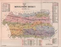
Punjab District Gazetteers. Montgomery District, Part A.
by WACE, F.B., I.C.S. AND F.C. BOURNE, I.C.S.
- Condition
- Used
- Edition
- Revised Edition.
- Published
- 1935.
- Quantity Available
- 1
- Seller
-
Canberra, Australian Capital Territory, AUS
- Item Price
-
€170.53
Show Details
Description:
Lahore.: Government Printing.. Revised Edition.. 1935.. Four folding colour maps, xi + 311 pages 26.5 x 18 cms; original papered boards (spotted and a trifle scuffed), linen backstrip with paper title label (worn); foredges and endpapers spotted, a few leaves toned, but on the whole in very good condition, the maps particularly bright and clean. A remarkable association copy:… Read more about this item Item Price
€170.53
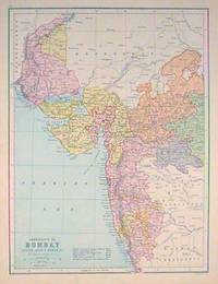
Presidency of Bombay Indore Agency Berar &c.
by [BOMBAY - MAP] BARTHOLOMEW, J. (ILLUS).
- Condition
- Used
- Published
- [circa1880s].
- Quantity Available
- 1
- Seller
-
Canberra, Australian Capital Territory, AUS
- Item Price
-
€77.51
Show Details
Description:
Edinburgh.: J. Bartholomew. [circa1880s].. Map 40.2 x 30.4 cms with printed colour and outline hand colour, in very good condition. Handsome map with colonial interests attractively coloured. . Item Price
€77.51
More Photos
Travelers' Map of Japan Chosen (Korea) Taiwan (Formosa) with Brief Descriptions of the Principal Tourist Points in Japan. 1927.
by [1920S TOURIST MAP - JAPAN, KOREA AND TAIWAN].
- Condition
- Used
- Published
- (Circa1927).
- Quantity Available
- 1
- Seller
-
Canberra, Australian Capital Territory, AUS
- Item Price
-
€232.54
Show Details
Description:
[Tokyo].: Japanese Government Railways.. (Circa1927).. Large folding colour map, 78.5 x 80 cm, of Japan and Korea, 6 inset maps one of which shows Taiwan, scale 1:1,640,000 for Hondo, Shikoku and Kyushu, 1:2340,000 for Chosen; tipped into the original orange cloth covered case with orange ties, text in 31 panels on the verso (one a little age-toned), a few… Read more about this item Item Price
€232.54
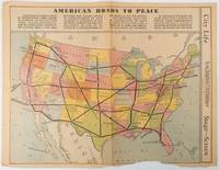
American Roads to Peace
by [PICTORIAL - PRE WWII MAP] BURKE, HOWARD AUSTIN [1899-1967.]
- Condition
- Used
- Published
- Sunday 1 May1938.
- Quantity Available
- 1
- Seller
-
Canberra, Australian Capital Territory, AUS
- Item Price
-
€201.53
Show Details
Description:
Los Angeles.: Los Angeles Examiner.. Sunday 1 May1938.. Printed colour pictorial map 33 x 48 cms; 41.8 x 54.5 cms (sheet) central fold, sheet toned, corners chipped with some loss to the bottom border and at the central fold, in good condition; and on the verso "Movie-Go-Round" by Louella O. Parsons, black and white photos and advertisements. Pictorial map… Read more about this item Item Price
€201.53
![東京中心神詣案内図. [Tōkyō chūshin kamimōde annaizu]. [Tokyo Central Shinto Pilgrimage Guide Map].](https://d3525k1ryd2155.cloudfront.net/h/242/820/1592820242.0.m.jpg)
More Photos
東京中心神詣案内図. [Tōkyō chūshin kamimōde annaizu]. [Tokyo Central Shinto Pilgrimage Guide Map].
by [KANSAI REGION PILGRIMAGE GUIDE].
- Condition
- Used
- Published
- 1937.
- Quantity Available
- 1
- Seller
-
Canberra, Australian Capital Territory, AUS
- Item Price
-
€279.04
Show Details
Description:
[Tokyo].: 東京鉄道局. [Tōkyō Tetsudōkyoku].. 1937.. Folding colour map, 53 x 76cm, text on reverse with some show-through on map as issued. A few small holes at folds now neatly mended, some light wear but overall an attractive and unusual map which we have not been able to locate in any library holdings of any library. Produced as part of Japan's… Read more about this item Item Price
€279.04
More Photos
The Mineral Wealth of Japan.
by [MINERAL RESOURCES OF JAPAN] MUNROE, HENRY S.
- Condition
- Used
- Published
- 1878.
- Quantity Available
- 1
- Seller
-
Canberra, Australian Capital Territory, AUS
- Item Price
-
€232.54
Show Details
Description:
Philadelphia.: American Institute of Mining Engineers. Sherman & Co., printers.. 1878.. Large folding map of Japan showing "some of the more important Mining Districts, Coal Fields etc." (small fold split without loss), tables, 67pp. Covers a little scuffed and discoloured, overall in very good condition. Scarce offprint separately paginated, of a paper included in Volume V of the Transactions of… Read more about this item Item Price
€232.54
![世界現勢解説地圖. [Sekai Gensei Kaisetsu Chizu]. [Explanatory Maps of the Present State of the World].](https://d3525k1ryd2155.cloudfront.net/h/273/568/1586568273.0.m.jpg)
More Photos
世界現勢解説地圖. [Sekai Gensei Kaisetsu Chizu]. [Explanatory Maps of the Present State of the World].
by [ISHIBASHI GORO, GENERAL EDITOR]. 石橋五郎監修.
- Condition
- Used
- Published
- Showa 12 [1937].
- Quantity Available
- 1
- Seller
-
Canberra, Australian Capital Territory, AUS
- Item Price
-
€155.02
Show Details
Description:
大阪朝日新聞社. [Osaka Asahi Shinbunsha].. Showa 12 [1937].. 10 colour maps (not including insets or sketch maps in text) on 12 pages. Handsome world map features as the centre fold, colour pictorial paper wrappers. A little light soiling and horizontal crease wrappers. An attractive atlas. 38 x 26.7cm. A large format atlas with six pages of coloured maps showing the… Read more about this item Item Price
€155.02
![北米合衆国全図. [Hokubei Gasshūkoku zenzu]. [Map of the United States of America].](https://d3525k1ryd2155.cloudfront.net/h/933/284/1586284933.0.m.jpg)
北米合衆国全図. [Hokubei Gasshūkoku zenzu]. [Map of the United States of America].
by [MEIJI MAP OF THE USA, INCLUDING ALASKA, HAWAII AND THE PHILIPPINES].
- Condition
- Used
- Published
- Meiji 44 [1911].
- Quantity Available
- 1
- Seller
-
Canberra, Australian Capital Territory, AUS
- Item Price
-
€186.03
Show Details
Description:
[Tokyo].: 楠山正雄. [Kusuyama Masao].. Meiji 44 [1911].. Colour folding map, 40 x 55cm, inset maps showing the Philippines, Alaska and Hawaii, very good copy. This map was a supplement of October 1911 issue of a monthly magazine Shin Nippon (新日本), which was published between 1911 and 1918. The main map covers the USA with inset maps of the world showing… Read more about this item Item Price
€186.03

More Photos
Rand McNally Official Map of Vietnam Laos and Cambodia.
by [VIETNAM LAOS CAMBODIA - WAR ERA MAP]
- Condition
- Used
- Published
- circa1970.
- Quantity Available
- 1
- Seller
-
Canberra, Australian Capital Territory, AUS
- Item Price
-
€46.51
Show Details
Description:
[Chicago].: Rand McNally.. circa1970.. Very large folding colour map, 136 x 89 cms folding to 30.5 x 22.8 cms, legend and glossary with a gazetteer in an upper corner to North and South Vietnam, Cambodia and Laos, small fold split (no loss), in very good condition. Extremely detailed map of Indochina (scale of 1 inch to approximately 20 miles) with… Read more about this item Item Price
€46.51
Rajpootana and Adjoining States Sheet No. 4.
by [INDIA - RAJASTHAN ANTIQUE MAP] SMITH, H.M. (LITHOGRAPHER).
- Condition
- Used
- Published
- 1870. Reissue of 1859 edition.
- Quantity Available
- 1
- Seller
-
Canberra, Australian Capital Territory, AUS
- Item Price
-
€294.55
Show Details
Description:
Calcutta.: Surveyor Generals Office.. 1870. Reissue of 1859 edition.. Lithographed map 57.2 x 93 cms; 61.1 x 96 cms (sheet), original folds, old paper repairs to the verso and a sealed marginal tear, central folds archivally strengthened, some toning to the folds and creasing, but the map in remarkably good, clean condition. Impressive large Calcutta printing from the Survey of… Read more about this item Item Price
€294.55
Map of Japan.
by [JAPAN & TAIWAN - MAP] OKISHIO, TAKACHIKA.
- Condition
- Used
- Published
- 1906.
- Quantity Available
- 1
- Seller
-
Canberra, Australian Capital Territory, AUS
- Item Price
-
€1,395.22
Show Details
Description:
Kobe, Japan.: Fuku-In-Kwan.. 1906.. Printed colour folding map on two conjoined sheets, laid down, 73.8 x 10⁵ cms, foxing on verso (not affecting map), single pinhole in each corner, scant spotting, small fold splits (no loss), a few soft fold creases, but in good condition. Very rare striking map of Japan published for the Western market.
Created under… Read more about this item Item Price
€1,395.22
More Photos
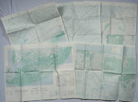
Khanh Hu'ng and Quan Long Vietnam. Series 1501 AIR. Sheets NC 48-10 & 11. Edition 2.
by [MEKONG DELTA - VIETNAM WAR MAPS]
- Condition
- Used
- Published
- 1967.
- Quantity Available
- 1
- Seller
-
Canberra, Australian Capital Territory, AUS
- Item Price
-
€130.22
Show Details
Description:
Washington, D.C.: Army Map Service.. 1967.. Two printed colour adjoining maps 73 x 55.6 cms and 55.6 x 73 cms, original folds, inked operational annotations to the Quan Long sheet, multiple marginal legends noting aerodromes and radio facilities, roads, railroads and boundaries, glossary of terms, much of the text is in both English and Vietnamese, in very good condition.… Read more about this item Item Price
€130.22
More Photos
A Series of Five Adjoining Vietnam War Era Maps.
by [VIETNAM WAR - MAPS]
- Condition
- Used
- Published
- 1967-1968.
- Quantity Available
- 1
- Seller
-
Canberra, Australian Capital Territory, AUS
- Item Price
-
€325.55
Show Details
Description:
Washington, D.C.: Army Map Service.. 1967-1968.. Five printed colour adjoining topographic maps (folded), legends to physical features including roads some including footpaths or trails, railroads, rivers, streams, lakes, mountains, boundaries and place names, Route Markers, Railroads, airfields, bridges and detailed terrain, a few including tea plantations, rice fields, coffee and rubber plantations. glossary of Vietnamese terms, in very… Read more about this item Item Price
€325.55

More Photos
World News of the Week. Monday, Apr. 13, 1942. Covering period Apr. 3 to Apr. 9. Military Edition.
by [WORLD MAP - WORLD WAR II]
- Condition
- Used
- Edition
- Volume 4, No. 32.
- Published
- 13 April1942.
- Quantity Available
- 1
- Seller
-
Canberra, Australian Capital Territory, AUS
- Item Price
-
€77.51
Show Details
Description:
Army Orientation Course. / News Map of the Week, Inc.. Volume 4, No. 32.. 13 April1942.. Folding colour pictorial map on sheet 88 x 119 cms, (blank on verso), inset maps (two photographic), diagrams and black and white photographic illustrations, descriptive text, top edge chipped, a few short edge tears and lower corner torn (no loss), pinholes at the corners,… Read more about this item Item Price
€77.51

More Photos
Formosa. Newsmap for the Armed Forces. V-E Day + 14 weeks - 191st Week of U.S. Participation. Monday, 13 August, 1945. Week of 31 July to 7 August.
by [TAIWAN - FORMOSA - WWII MAP]
- Condition
- Used
- Edition
- Volume IV, No. 17 B/F.
- Published
- 13 August,1945.
- Quantity Available
- 1
- Seller
-
Canberra, Australian Capital Territory, AUS
- Item Price
-
€620.10
Show Details
Description:
New York.: Army Information Branch.. Volume IV, No. 17 B/F.. 13 August,1945.. Large folding aerial-style map 116.5 x 64 cms; 119.56 x 86 cms (sheet), black and white inset of East Asia noting the strategic position of Formosa with a lengthy explanatory note in red, on the verso a central panel with text relating to the Potsdam Conference, black and… Read more about this item Item Price
€620.10

More Photos
New Map of Japan.
by [WWII MAP OF JAPAN] TSUTSUKI, T.
- Condition
- Used
- Published
- 1935
- Quantity Available
- 1
- Seller
-
Canberra, Australian Capital Territory, AUS
- Item Price
-
€279.04
Show Details
Description:
Tokyo.: Nihon-Kenkyusha.. 1935. Large folding colour map of Japan 74.3 x 10⁵ cms; folding into printed card covers 27 x 19.5 cms: 9 insets: Chosen (Korea); Hokkaido; Chisima Islands; General Map of Japan and Manchuokuo; Karafuto (Saghalien); Okinawa (Loochoo); Taiwan (Formosa); Micronesia; Ogasawara; Hajijoshima; the covers a litle worn and marked, and the sheet slightly toned, but the map is… Read more about this item Item Price
€279.04
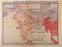
Jap Drive into India perils entire Allied strategy in Pacific
by [WORLD WAR II - MAP] BURKE, HOWARD; C.A.B.
- Condition
- Used
- Published
- April 31944.
- Quantity Available
- 1
- Seller
-
Canberra, Australian Capital Territory, AUS
- Item Price
-
€403.06
Show Details
Description:
Los Angeles.: Los Angeles Examiner.. April 31944.. Colour pictorial map on a single newspaper leaf 37 x 50 cms; 41.5 x 54.6 cms (sheet), unrelated text on the verso (although with an interesting account from a soldier's letter about an air raid in China), toning, more marked at the central fold (two small splits, no loss to the map), edge… Read more about this item Item Price
€403.06
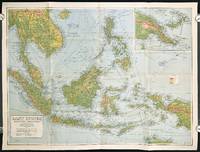
East Indies. Mercators Projection. Map No. 316.
by [SOUTHEAST ASIA - WORLD WAR II ERA MAP]
- Condition
- Used
- Published
- circa1940.
- Quantity Available
- 1
- Seller
-
Canberra, Australian Capital Territory, AUS
- Item Price
-
€217.04
Show Details
Description:
Sydney.: H.E.C. Robinson Pty. Ltd.. circa1940.. Full colour folding map, 71 x 97 cms; 76.2 x 10² cms (sheet), blank on verso, save for a neat inked stamp "East Indies", inset map of New Guinea and Papua, heights shown by colour, very good, clean condition. Large scale World War II era map by Sydney publisher H. E. C.… Read more about this item Item Price
€217.04
