Description:
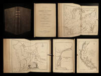
Flat with plastic against dirtExcellent early map of the region. Kansas counties cover only the eastern third of the state. Nebraska counties cover less than half the state. Colorado has only approximately 15 counties. The gold regions near Denver are shown, as are a number of Indian tribes, early towns, forts, etc. Dakota includes all of Wyoming.The map shows early proposed railroads, forts, Indian tribes, rivers, mountains, etc. The plains region is still very much in transition, with the results of several major explorations commenced immediately after the civil war are not yet in evidence.
Also shows portions of New Mexico, Texas and Indian Territory.