Description:
Nuremburg: J. B. Homann, 1730. Hand-coloured engraving. Good condition, margins re-backed to restore several minor losses and tears. A dramatic star chart by Doppelmayr illustrating the autumnal and early winter zodiacal signs: part of Libra, Scorpio, Sagittarius, and part of Capricorn. Johann Gabriel Doppelmayr (1677-1750) was a Nuremberg astronomer and mapmaker, who made globes, star charts, moon charts and completed Homann's Atlas Coelestis in 1742. This is part V of a group of six showing the entire panorama of the night sky as known and represented in the early 18th century. The stars are differentiated according to magnitude, and there is an extensive star index on each side of the chart. Johann Batiste Homann (1663-1724) began his professional life as an engraver for others, founding his own cartographical firm in 1702. He brought back to life German mapmaking, which virtually ceased in the early 16th century, using Dutch cartography as his guide and starting point.
Riverhead Suffolk County New York Atlas by (Riverhead) - 1909
by (Riverhead)

Riverhead Suffolk County New York Atlas
by (Riverhead)
- Used
- very good
- Paperback
New York: Sanborn Map Company, 1909. List of Maps collated complete; all are hand colored; 11 double page maps, approximately 21" x 25" size opened; Locations include all of the town and surrounds of Riverhead, Long Island, listing businesses, fire houses, water facilities, public utilities, Suffolk County Agricultural Society Fair Grounds with Race Track, Peconic River and all the businesses at the riverside in this time: Tower Roller Mill, C. Hallet's Sons Flour Mill & Electric Light Plant, Auxiliary Plant, Carriage Repository, Lumber & Construction businesses, boat & carpenter shops, American Ice Company, Frank H. Hill & Bro. Monument Works, county buildings-court house complex & jail, Long Island House, Banks, Public Library, tailor, jewelry, drug, tobacco & cigarette retailers, horse boarding & livery stables, S. Terry Hudson Agricultural Implement Works, Riverhead Coal Co., Shinnecock Distributing Co., Beer Agents & Soda Water Bottlers, railroads- train & transportation lines; Wm. Sweezy's Ice Ho., Corwin & Vail Lumber, cemeteries, schools, residences, public works, boarding houses-ie. Benjamin House, E. Griswold & Co., Cigar Factory & Wholesale Candy Dealers, F. C. Lane's Ice House, and much more; bound in the original paper wraps, covers soiled and with old fold line; with slight marginal soiling and darkening, a little bit of edgewear to a few; a bit of bowing from old fold; maps are in very good plus condition overall and clean, colors bright, printed on very good paper with good margins.. Soft Cover. Very Good.
-
Bookseller
Independent bookstores
 (US)
(US)
- Format/Binding Paperback
- Book Condition Used - Very Good
- Binding Paperback
- Publisher Sanborn Map Company
- Place of Publication New York
- Date Published 1909
- Keywords 1 Atlas Maps Sanborn Map Company Riverhead Suffolk County New York Atlas Long Island Fire Houses Water Facilities Public Utilities History Americana Businesses fire houses water facilities public utilities Suffolk County Agricultural Society Fair Grounds

More Photos
[A portion of the celestial hemisphere showing part of Libra, Scorpio, Sagittarious and part of Capricorn] Globi Coelestis in Tabulas Planas Redacti Pars V in qua Longitudines Stellarum fixarum ad anum Christi completum 1730 tam Arithmetice quam Geometrice exhibentur..
by DOPPELMAYR, Johann Gabriel (1677-1750)
- Used
- Condition
- Used
- Binding
- Unknown
- Quantity Available
- 1
- Seller
-
New York, New York, United States
- Item Price
-
€1,597.15
Show Details
Item Price
€1,597.15

More Photos
Chios. "Chios Maris Aegæ ieiusdem nominis Insulae Civitas
by Braun & Hogenberg
- Used
- Condition
- Used
- Binding
- Unknown
- Quantity Available
- 1
- Seller
-
Nafplion, Greece
- Item Price
-
€1,200.00
Show Details
Description:
Greece: Cologne G von Kempen 1588. Copper engraved view of Chios from the fourth volume of Braun & Hogenberg's "Civitas Orbis Terrarum. " Latin text to verso; black & white as issued. The engraving shows the port and capital of Chios, seen from the east in a bird's-eye view. The town is represented as divided into the strongly fortified Byzantine Kastro and the town itself, which is defended on the landward side by massive watchtowers with a moat and a drawbridge. Windmills line the coast; A canon fire s out to sea from a tower on the sea wall; numerous ships and galleys. Decorative title cartouche The city is often locally referred to as "Chora" (Χώρα; literally meaning "town") or "Kastro" (Κάστρο) to distinguish it from the entirety of the island with which it shares the name. Originally the site of an ancient settlement, the town was first built at the north side of a natural harbour. By the 16th century, the walled town had been further fortified by successive rulers into a massive…
Read More Item Price
€1,200.00

More Photos
A System of Geography: or, A New & Accurate Description of the Earth in all its Empires, Kingdoms and States. Illustrated with History and Topography and Maps of every Country. Fairly engraven on copper, according to the latest discoveries and Corrections
by Moll, Herman and Rober Falconer
- Used
- first
- Condition
- Used
- Edition
- First Edition
- Binding
- Unknown
- Quantity Available
- 1
- Seller
-
Scottsdale, Arizona, United States
- Item Price
-
€1,761.56
Show Details
Description:
London: For A. and J. Churchil and T. Childe, 1701. First Edition. Folio. From the library of John, Earl of Loudoun (John Campbell, Fourth Earl of Loudoun (5 May 1705 - 27 Apr. 1782) In 1727, Campbell entered the Army. He was commissioned major general in 1755, and appointed the following year as commander-in-chief of British forces in America during the French and Indian War, and named titular governor of Virginia. Variant issue, with both Churchil & Childe in imprint, 2 parts in 1 volume. Frontispiece, title page in red and black, 4; [24] contents, 444pp; 1-230; [28]pp. index. While the collation is haphazard, the book itself is complete with all catchwords matching, (with dupicate 125 pagination as in all copies) Frontispiece, 2 Engravings of Ptolomei and Copernici systems; 2 engraved compasses; and 44 textual maps, (45 maps if one counts the small china strip map).Contains the following maps. 1. Earth 2. Europe 3. Britain 4.Scotland 5. Ireland 6. France 7. Netherlands 8. United…
Read More Item Price
€1,761.56

More Photos
Travels in the Interior Districts of Africa: Performed under the direction and patronage of the african association, in the years 1795, 1796, and 1797. with an appendix, containing illustrations of Africa by Major Rennel
by PARK, Mungo
- Used
- very good
- Hardcover
- Condition
- Used - Very Good
- Edition
- 2nd
- Binding
- Hardcover
- Quantity Available
- 1
- Seller
-
Cuernavaca, Morelos, Mexico
- Item Price
-
€1,493.80
Show Details
Description:
London, W.Bulmer and Co., 17994º. xxviii,(2),372 pp., xcii. Bound to style in a fine later calf. Title-and tomelabels with gilt lettering. Blindtoolings to bands and compartments of spine. Engraved portrait as frontispiece, 2 engraved plates with music, 5 engraved plates (of which 3 are views) and 3 large folded engraved maps. One map strenghtened in foldings and edges, one map with a closed tear to folding. Wide-margined, a few margins slightly brownspotted. Light offsetting to title and portrait.
Second edition - the same year as the first - of this classic work of travel litterature.
"Until the publicationof Park's book in 1799 hardly anything was known of the interior of Africa, apart from the north-east region and coastal areas....the real opening up of Africa by the white races began with the African Association, founded in 1788 with the express purpose of exploring Africa and furthering British tradee and political influence onthe continent...Parks travels had an immediate success and was… Read More
Item Price
€1,493.80
More Photos
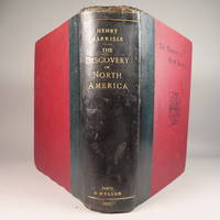
The Discovery of North America, A Critical, Documentary, and Historic Investigation,: with an essay on the early cartography of the New World, including descriptions of two hundred and fifty maps or globes existing or lost, constructed before the year 1536...
by Henry Harrisse
- Used
- very good
- Hardcover
- first
- Condition
- Used - Very Good
- Edition
- First Edition
- Binding
- Hardcover
- Quantity Available
- 1
- Seller
-
Fort Lauderdale, Florida, United States
- Item Price
-
€1,362.28
Show Details
Description:
Quarter morocco over pictorial maroon cloth board with gilt particulars to spine. Top edge gilt. Limited edition copy No. 91 of 380 issued, this being the English Toned Paper edition. Hors textes plates with tissue guards throughout. Black and white illustrations throughout text as well. Title continued: "to which are added a chronology of one hundred voyages westward, projected, attempted, or accomplished between 1431 and 1504; biographical accounts of the three hundred pilots who first crossed the Atlantic; and a copious list of the original names of American regions, caciqueships, mountains, islands, capes, gulfs, rivers, towns, and harbours." Topics include: John Cabot, Gaspar Corte-Real, Christopher Columbus, Ancient Maps, First Knowledge of Florida, Colonisation [colonization] of Nova Scotia, Aliminos, Pardon Real, Lusitano-Germanic Cartography, and much more. Wear to head of spine and hinges, but still intact and sturdy. 802 pp. 9 3/4 x 11 3/4. A clean, bright volume without previous owners'…
Read More Item Price
€1,362.28

TOPOGRAPHICAL SURVEY OF THE GREAT ROAD FROM LONDON TO BATH AND BRISTOL. With historical and descriptive accounts of the country, towns, villages, and gentlemen's seats on and adjacent to it; illustrated by perspective views of the most select and picturesque scenery. To which is added a correct map of the country three miles on each side of the road, planned from a scale of one inch to a mile.
by Robertson,Archibald
- Used
- Hardcover
- Condition
- Used - Very Good-
- Binding
- Hardcover
- Quantity Available
- 1
- Seller
-
Blockley, Gloucestershire, United Kingdom
- Item Price
-
€1,252.12
Show Details
Description:
London: For the author & William Faden (replaced by R.Faulder in vol.2), 1792. Hardcover. Very Good-. Aquatint plates (65 as listed) + 11 folding Maps. . 2 VOLUMES IN ONE 223x141mm green calf gilt key pattern border & spine gilt, gilt dent. & rev. (tips & hinges rubbed/spine darkened) All Edges Gilt Dedication to Prince of Wales the future George IV. TP + xvi =Dedic.+Introduction + contents & plate list +154pp Titlepage to Part II +viii=Contents & Plate list + 190pp+errata + 11 folding Maps. Coat of Arms bookplate James Forbes esq. & F.Fisher written in. Short tears to gutter edge - no loss - to first 3 leaves else a clean copy. Slight offset from plates to facing text but no foxing and great views with horses, coaches, people, boats etc. The maps without and misfold or tears -they look unused. A clean copy of a lovely aquatint book.
Item Price
€1,252.12
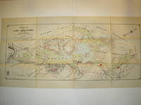
Property Map of Lake Hopatcong, New Jersey, Prepared by Hudson Maxim for the Morris Canal Investigation Commission, November 16, 1912, Compiled from Various Maps and Actual Surveys by P. E. Boomer, C. E.
by Maxim, Hudson; & P. E. Boomer
- Used
- Paperback
- first
- Condition
- Used - Near Fine condition
- Edition
- First Edition
- Binding
- Paperback
- Quantity Available
- 1
- Seller
-
Henderson, Nevada, United States
- Item Price
-
€1,404.55
Show Details
Description:
Borough of Hopatcong, New Jersey?, 1912. Near Fine condition. SEE PHOTO. This is a beautiful and very scarce color map of Lake Hopatcong, New Jersey. When unfolded it measures 18" tall by 38" wide. Some folds have been neatly reinforced on the blank side with archival-quality document repair tape. Buildings are represented by red squares, water in green. Some of the properties and locations depicted are: Port Morris, Landing, Roxbury Township, Borough of Mount Arlington, Byram Township, Nolans Point, Atlas Powder Co., Brookland, Borough of Hopatcong, Byram Cove, Henderson Bay, Byram Bay, Maxim Park, Jefferson Township, Woodport, Hurdtown, Hurd Mining Co., W. M. Force Estate, John P. Lawless, Mary Ingram estate, Aaron Peck estate, Raccoon Island, Halsey Island, Bertrand Island, Theodore King, Gertrude Otten, Violet Littell, Robert Dunlap estate, etc. Full title: "Property Map of Lake Hopatcong, New Jersey, Prepared by Hudson Maxim for the Morris Canal Investigation Commission,…
Read More Item Price
€1,404.55

The island of Crete and the adjacent islands of the Aegean with the new island of Santorini ... "Insuls Creta nunc Candia in sua IV Territoria distinicta, cum aliqoud adjacentibus Ægei maris Insulis imprimis Nova Santorini insula modo ante XXVII annos ex abysso marsi emersa..." "Creta nunc Candia
by Lotter Conrad Tobias
- Used
- Condition
- Used
- Binding
- Unknown
- Quantity Available
- 1
- Seller
-
Nafplion, Greece
- Item Price
-
€1,500.00
Show Details
Description:
Greece: Augsburg, Lotter Conrad Tobias 1772. Copper engraved map of Crete with View of Iraklion after Seutter from Lotters "Atlas Novus." . Original old colour; verso blank The map shows the island of Crete, taken from the Homann map of 1712 [ Zacharakis 1641/1879] with the a long text beside the newly emerged island at Santorini following the volcanic eruption of 25th May 1707: "In 1707, activity began again, the small when two cones appeared. They were called Aspronisi and Macronesi. Those were united in the course of the following five years by an island which formed between Palea and Small Kameni, much larger and higher then either and was called Nea (New) Kameni .This island, is the youngest island in Greece."[Santorini Living ] Below is a panaromic view of Iraklion, black & white as issued. The map was first published by Lotter's father-in-law Matthaüs Seutter in his "Atlas Novus" in 1728 who took the lower part of Homann's map re-engraved the cartouche and text and added the scale to the…
Read More Item Price
€1,500.00

More Photos
富士見十三州輿地全圖. [Fujimi Jūsanshū yochi zenzu]. [Map of the Thirteen Provinces From Where Mt. Fuji Is Visible].
by AKIYAMA EINEN [OR NAGATOSHI] 秋山永年.
- Used
- Condition
- Used
- Edition
- [Reprint].
- Binding
- Unknown
- Quantity Available
- 1
- Seller
-
Canberra, Australian Capital Territory, Australia
- Item Price
-
€1,551.25
Show Details
Description:
Shūseidō 衆星堂. [Reprint].. Tenpō 14 (1843).. Large folding handcoloured map of the thirteen provinces from which Mt. Fuji can be viewed. 159 x 178cm. Folds into paper covered card covers measuring 40 x 24cm. Title label upper cover. A little browning along folds, occasional spotting and soiling. A little worming causing approximately 1cm of loss in places. Two chops in lower section. A very striking and attractive map. This very large handsome map is a detailed map of the thirteen provinces from which one can see Mt. Fuji. Provinces shown are the eight provinces of the Kantō region, Sagami 相模, Musashi 武蔵, Kazusa 上総, Shimofusa 下総, Awa 安房, Kōzuke 上野, Shimotsuke 下野, and Hitachi, 常陸, and five other provinces, Izu 伊豆, Suruga 駿河, Tōtōmi 遠江, Kai 甲斐, and Shinano 信濃. The map…
Read More Item Price
€1,551.25

More Photos
Le nouveau et curieux Atlas Geographique et historique...
by Chiquet (Jacques) [Antoine Menard].
- Used
- Hardcover
- Condition
- Used
- Binding
- Hardcover
- Quantity Available
- 1
- Seller
-
Sidney, British Columbia, Canada
- Item Price
-
€2,113.88
Show Details
Description:
Paris: chez Chereanau, [1719].. Oblong small 4to. Full vellum with ties. Wear at edges, chip from fore-edge of lower front cover,blank end leaves are heavily annotated and written-upon in 18th & 19th century hands. Old stains to margins and a few maps, old paper-tape repairs to the verso of the Asia map, but generally very good. Engraved allegorical title page, 3 plates (two of globes), and 24 maps opposite explanatory text in French. 23 maps have contemporary hand-colouring in outline; a couple have attractively coloured cartouches. The Globe Terrestre map, of two hemispheres, is holed, slightly affecting the title. The map of North America shows California as an island. This is the second or third edition of this atlas, originally by Antoine Menard, first published by Chiquet in [1711 & 1713], with most of the maps dated 1709-1711. In this 1719 edition Chiquet has removed Menard's name entirely; on many of the maps (such as L'Amerique Septentrionale) he has changed it to his own name and altered…
Read More Item Price
€2,113.88

The Good Soldiers
by Moody, William B
- Used
- very good
- Hardcover
- Signed
- first
- Condition
- Used - Very Good
- Jacket Condition
- Very Good
- Edition
- First Edition
- Binding
- Hardcover
- ISBN 10 / ISBN 13
- 9780961649906 / 0961649909
- Quantity Available
- 1
- Seller
-
Southampton, New York, United States
- Item Price
-
€0.94
Show Details
Description:
Good Soldier Pub. First Edition. Hardcover. Very Good/Very Good. First Edition, First Printing. Published by Good Soldiers Publishing, 1986. Octavo. Green boards stamped in gold. Signed and inscribed by author on flyleaf. Book is very good; clean with no writing or names. Sharp corners and spine straight. Binding tight and pages crisp. Dust jacket is very good with light shelf wear with small tears on bottom front and back top edge. 130 pages. ISBN: 0961649909. 100% positive feedback. 30 day money back guarantee. NEXT DAY SHIPPING! Excellent customer service. Please email with any questions or if you would like a photo. All books packed carefully and ship with free delivery confirmation/tracking. All books come with free bookmarks. Ships from Southampton, New York.
Item Price
€0.94
Penguin Books
by 1
- Used
- Condition
- Used
- Quantity Available
- 1
- Seller
-
Philadelphia, Pennsylvania, United States
- Item Price
-
€0.94
Item Price
€0.94
HOTEL HOUSEKEEPING: OPERATIONS AND MANAGEMENT, 3RD EDN
- Used
- Paperback
- Condition
- Used - Paperback
- Binding
- Paperback
- Quantity Available
- 1
- Seller
-
New Delhi, India
- Item Price
-
€0.94
Show Details
Description:
G. Raghubalan ET AL", 9780199451746. 2015. Paperback. HOTEL HOUSEKEEPING: OPERATIONS AND MANAGEMENT, 3RD EDN ,
Item Price
€0.94
Intl City County Management Assn
by 1
- Used
- Condition
- Used - 2
- Quantity Available
- 1
- Seller
-
Philadelphia, Pennsylvania, United States
- Item Price
-
€0.94
Show Details
Description:
2.
Item Price
€0.94

Inferno
by Dan Brown
- Used
- Hardcover
- Condition
- Used - Good-
- Jacket Condition
- missing
- Binding
- Hardcover
- ISBN 10 / ISBN 13
- 9780593072493 / 0593072499
- Quantity Available
- 1
- Seller
-
Prague, Czech Republic
- Item Price
-
€1.00
Show Details
Description:
test
Item Price
€1.00

Stock Photo: Cover May Be Different
Oxford Bookworms Library Level 3 The Three Strangers and Other Stories (Oxford Bookworms) (papaerback)
by Thomas Hardy
- Used
- Paperback
- Condition
- Used - Damaged
- Binding
- Paperback
- ISBN 10 / ISBN 13
- 9780194230254 / 0194230252
- Quantity Available
- 1
- Seller
-
Prague, Czech Republic
- Item Price
-
€1.00
Show Details
Description:
Justice is meant to balance an inequality. However, in this story, Timothy Summers stole a sheep due to his family starving and his punishment is to die. This doesn't return equality and it isn't fair. So the true justice is for him not to die.
Item Price
€1.00

More Photos
Stones into Schools
by Greg Mortenson
- Used
- Hardcover
- Condition
- Used
- Binding
- Hardcover
- ISBN 10 / ISBN 13
- 9780670021154 / 0670021156
- Quantity Available
- 1
- Seller
-
Prague, Czech Republic
- Item Price
-
€1.00
Show Details
Description:
In this dramatic first-person narrative, Greg Mortenson picks up where Three Cups of Tea left off in 2003, recounting his relentless, ongoing efforts to establish schools for girls in Afghanistan; his extensive work in Azad Kashmir and Pakistan after a massive earthquake hit the region in 2005; and the unique ways he has built relationships with Islamic clerics, militia commanders, and tribal leaders. He shares for the first time his broader vision to promote peace through education and literacy, as well as touching on military matters, Islam, and women—all woven together with the many rich personal stories of the people who have been involved in this remarkable two-decade humanitarian effort.
Item Price
€1.00

Inferno
by Dan Brown
- Used
- good
- Condition
- Used - Good
- ISBN 10 / ISBN 13
- 9780593072493 / 0593072499
- Quantity Available
- 1
- Seller
-
Prague, Czech Republic
- Item Price
-
€1.00
Show Details
Description:
Inferno is a 2013 mystery thriller novel by American author Dan Brown and the fourth book in his Robert Langdon series, following >Angels & Demons, The Da Vinci Code and The Lost Symbol. The book was published on May 14, 2013, ten years after publication of The Da Vinci Code (2003), by Doubleday.[1] It was number one on the New York Times Best Seller list for hardcover fiction and Combined Print & E-book fiction for the first eleven weeks of its release, and also remained on the list of E-book fiction for the first seventeen weeks of its release. A film adaptation was released in the United States on October 28, 2016.
Item Price
€1.00

Manning, Martha | Undercurrents | Unsigned First Edition Copy
by Manning, Martha
- Used
- Fine
- Hardcover
- first
- Condition
- Used - Fine
- Binding
- Hardcover
- ISBN 10 / ISBN 13
- 9780062511836 / 0062511831
- Quantity Available
- 44
- Seller
-
Tualatin, Oregon, United States
- Item Price
-
€2.81€1.13Save €1.79!
Show Details
Description:
HarperCollins, 1995. hardcover. Fine. First Edition Hardcover Book. November 1995 NY: HarperCollins First edition, first printing, fine in a fine dust jacket, remainder marked.
Item Price
€2.81€1.13
Save €1.79
!
Stock Photo: Cover May Be Different
The Federal Reserve Monster: Jack Holland Illustrated Edition
by Sam H Clark
- Used
- good
- Paperback
- Condition
- Used - Good
- Edition
- Ill
- Binding
- Paperback
- ISBN 10 / ISBN 13
- 9781461127536 / 146112753X
- Quantity Available
- 1
- Seller
-
HOUSTON, Texas, United States
- Item Price
-
€1.46
Show Details
Description:
CreateSpace Independent Publishing Platform, 2011-04-29. Ill. Paperback. Good.
Item Price
€1.46

More Photos
The Sky and the Forest
by Forester, C.S
- Used
- very good
- Hardcover
- first
- Condition
- Used - Very Good
- Jacket Condition
- Very Good
- Edition
- First Edition
- Binding
- Hardcover
- Quantity Available
- 1
- Seller
-
Salem, Oregon, United States
- Item Price
-
€32.78€16.39Save €17.44!
Show Details
Description:
C.S. Forester: The Sky and the Forest. Little, Brown and Company, Boston. Stated First Edition First Printing Thus August, 1948. Cover price $2.75. Used. VG BOOK/VG UNCLIPPED DUST JACKET. A story of a central Africa. By C.S. Forester, author of the Admiral Hornblower series.
Item Price
€32.78€16.39
Save €17.44
!

More Photos
Plat Book: Pierce County, Wisconsin
by Rhame, A. E
- Used
- Fine
- Paperback
- Condition
- Used - Fine
- Binding
- Paperback
- Quantity Available
- 1
- Seller
-
Woodruff, Wisconsin, United States
- Item Price
-
€43.84
Show Details
Description:
1930. Soft Cover. Fine. Unpaginated. Tan colored book is in Fine condition, no sign of wear.
Item Price
€43.84
![Alaska and Klondike Region; [With inset of Klondike Region on the Upper Yukon detail] [From an...](https://d3525k1ryd2155.cloudfront.net/h/062/537/1339537062.0.m.jpg)
Alaska and Klondike Region; [With inset of Klondike Region on the Upper Yukon detail] [From an atlas, "Gazetteer of Alaska and Yukon Region " pp. 105 and 106]
by Miller, J. Martin
- Used
- very good
- Condition
- Used - Very Good
- Edition
- Unknown
- Quantity Available
- 1
- Seller
-
Sebastopol, California, United States
- Item Price
-
€36.64
Show Details
Description:
Chicago: J. Martin Miller, 1899. Unknown. Map. Very Good. [Map copyright 1899, printing date of Atlas later] [19.875x15.125in]; Colored map of Alaska with steamer routes from Portland and Seattle, insets of the Klondike Region on the Upper Yukon and Western portion of Aleutian Islands; On verso index of places and names with two large black and white images; Age toning to all edges, water stain marks on bottom, slight printing offset of colors, small chips and closed tears to lower edge;.
Item Price
€36.64

Zemepis Sveta - Monsunova Asie
by De La Blache, P. Vidal; Gallois, L
- Used
- Hardcover
- Condition
- Used - Very Good Condition
- Jacket Condition
- No Dust Jacket
- Binding
- Hardcover
- Quantity Available
- 1
- Seller
-
Oak Point, Texas, United States
- Item Price
-
€56.37
Show Details
Description:
Aventinum, Prague, Czechoslovakia, 1930. Hardcover. Very Good Condition/No Dust Jacket. Text entirely in Czech. Geography book on Asia with numerous photographs and maps. 1931 edition also available. Size: 4mo - over 9 3/4" - 12" tall. 400 pp. Pages are yellowed, but are tight and clean. Moderate shelfwear along the spine. Corners are lightly bumped. Quantity Available: 1. Shipped Weight: 3-5 pounds. Category: Travel & Places; Non-English Language::Czech; Pictures of this item not already displayed here available upon request. Inventory No: 001227. . Additional shipping charges may apply.
Item Price
€56.37

Zemepis Sveta - Monsunova Asie
by De La Blache, P. Vidal; Gallois, L
- Used
- Hardcover
- Condition
- Used - Very Good Condition
- Jacket Condition
- No Dust Jacket
- Binding
- Hardcover
- Quantity Available
- 1
- Seller
-
Oak Point, Texas, United States
- Item Price
-
€56.37
Show Details
Description:
Aventinum, Prague, Czechoslovakia, 1931. Hardcover. Very Good Condition/No Dust Jacket. Text entirely in Czech. Geography book on Asia with numerous photographs and maps. 1930 edition also available. Size: 4mo - over 9 3/4" - 12" tall. 400 pp. Pages are yellowed, but are tight and clean. Moderate shelfwear along the spine. Corners are lightly bumped. Quantity Available: 1. Shipped Weight: 3-5 pounds. Category: Travel & Places; Non-English Language::Czech; Pictures of this item not already displayed here available upon request. Inventory No: 001228. . Additional shipping charges may apply.
Item Price
€56.37

Last Tales
by Dinesen, Isak
- Used
- very good
- Hardcover
- first
- Condition
- Used - Very Good
- Jacket Condition
- Good+
- Edition
- First Edition
- Binding
- Hardcover
- Quantity Available
- 1
- Seller
-
Salem, Oregon, United States
- Item Price
-
€112.74€56.37Save €60.00!
Show Details
Description:
Dinesen, Isak: Last Tales, A Collection of Twelve New Tales of Compelling Beauty 1957, Random House. First Edition. Stated First Printing Thus. Used. Very Good/Good+ original red dust jacket, price-clipped. Jacket states 11/57 on front flap. 5 3/4 X
Item Price
€112.74€56.37
Save €60.00
!

The Adventure of Wrangel Island
by Vilhjalmur Stefansson
- Used
- good
- Hardcover
- first
- Condition
- Used - Good
- Jacket Condition
- No DJ Included
- Edition
- First Edition
- Binding
- Hardcover
- Quantity Available
- 1
- Seller
-
Salem, Oregon, United States
- Item Price
-
€117.33€58.67Save €62.44!
Show Details
Description:
The Adventure of Wrangel Island, Alaska (1925 Macmillan 1st Edition) HISTORY OF ALASKA. EXLIB. Good Condition/ No DJ included. Fold-out map affixed to binding at the back of the book has never been opened. The story of the (unsuccessful) attempted colonization of Wrangel Island Alaska. 413 pages plus appendix, Index. Titling is still bright. A clean, solid copy. Scarce.
Item Price
€117.33€58.67
Save €62.44
!

Seven Pillars Of Wisdom, A Triumph
by Lawrence, T.E
- Used
- good
- Hardcover
- first
- Condition
- Used - Good
- Jacket Condition
- No DJ Included
- Edition
- First American Edition
- Binding
- Hardcover
- Quantity Available
- 1
- Seller
-
Salem, Oregon, United States
- Item Price
-
€117.39€58.70Save €62.47!
Show Details
Description:
T.E. Lawrence. SEVEN PILLARS OF WISDOM, A TRIUMPH. AUTOBIOGRAPHY. Privately Printed, 1926. First Published for general circulation 1935. First American Edition. States MCMXXXVI on the title page. Doubleday, Doran & Company, Inc. Garden City, NY. GOOD CONDITION/ NO DUST JACKET IS INCLUDED. 672 pages, indexed. Beige buckram boards. Spine has darkened a bit. 6 7/8 X 9 ½.
Item Price
€117.39€58.70
Save €62.47
!

Asia from the Best Authorities, Russell, ca.1800
by Russell
- Used
- Condition
- Used
- Quantity Available
- 1
- Seller
-
Plymouth, Devon, United Kingdom
- Item Price
-
€23.54
Show Details
Description:
Russell, J. : Asia from the Best Authorities. Nd but ca.1800. From "A New Geographical, Historical and Commercial Grammar and Present State of Several Kingdoms of the World". Copper engraving. Size approx 200 x 230mm. Two neat folds. Some age colouring to edges, otherwise clean and bright. Includes Arabia, India, Borneo, Japan, China and eastern Russia.
Item Price
€23.54

North America from the Best Authorities, Russell, ca.1800
by Russell
- Used
- Condition
- Used
- Quantity Available
- 1
- Seller
-
Plymouth, Devon, United Kingdom
- Item Price
-
€23.54
Show Details
Description:
Russell, J. : A General Map of North America from the Best Authorities. Nd but ca.1800. From "A New Geographical, Historical and Commercial Grammar and Present State of Several Kingdoms of the World." Copper engraving. Size approx 200 x 230mm. Two neat folds. Some age colouring to edges, otherwise very clean and bright.
Item Price
€23.54