Description:
Albrizzi, 1743, Venice. Very Good. Prompt shipment, with tracking. we ship in CLEAN SECURE NEW boxes Full margins, uncolored, slight tearing to edges, folded with some repair to two folds. Very good. *
A Representation of the Solar System with the Comparative Sizes of the Planets by Salmon, Thomas - 1772
by Salmon, Thomas

A Representation of the Solar System with the Comparative Sizes of the Planets
by Salmon, Thomas
- Used
"A Representation of the Solar System with the comparative Sizes of the Planets" by Thomas Salmon c1772. 250 x 170 mm. From the 12th Edition of "A new geological and historical grammar..." published in London 1772.
This is a very nice 18th century astronomy illustration suitable for display. Some minor foxing and light discoloration along the edges. Illustrations and text are clear and legible. Intact. Excellent copy of this illustration of the contemporary understanding of the Solar System at that time.
-
Seller
Independent bookstores
 (US)
(US)
- Book Condition Used
- Quantity Available 1
- Place of Publication London
- Date Published 1772
- Size 250mm x 170mm
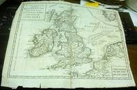
Nuova Carta dell' Isole Britanniche divise nei tre Regni d'Inghilterra, di Scozia, e d'Irlanda by [L'Isle (Guillaume de)]
by [L'Isle (Guillaume de)]
- Used
- Very Good
- Condition
- Used - Very Good
- Binding
- Unknown
- Quantity Available
- 1
- Seller
-
Binghamton, New York, United States
- Item Price
-
€191.68
Show Details
Item Price
€191.68

More Photos
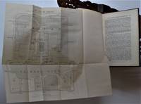
Hydraulics of Great Rivers, the Parana, the Uruguay and the la Plata Estuary
by J.J. Révy
- Used
- Good
- Hardcover
- first
- Condition
- Used - Good
- Jacket Condition
- No Jacket
- Edition
- First Edition
- Binding
- Hardcover
- Quantity Available
- 1
- Seller
-
Harleston, Norfolk, United Kingdom
- Item Price
-
€178.35
Show Details
Description:
London: E.and F.N. Spon, 1874. First Edition. Hardback. Good/No Jacket. 2339 Folio. With charts and tables, all as called for. In original black cloth-covered boards, blind stamped, gilt titles. An account of the surveying of three of the largest rivers in the world, undertaken under considerable pressure of time, to enable proposed engineering works. The work included development of an improved current meter, based on one that was just being offered to market as the expedition was being planned. Of the device offered to him, which had been simplified from a sound design in order to make it "easier" to use, the author wrote "all these attempts at making things very easy is a mistake, for they tend to make things very useless" - a sentiment which is likely to ring true for many of us today. Condition notes: Boards bumped and rubbed, title page just starting to pull away from its binding, and some foxing to the prelims. Apart from the early foxing, the pages are clean and…
Read More Item Price
€178.35

More Photos
Digging the Old West: How Dams and Ditches Sculpted an American Landscape
by Franklin, Karmen Lee
- Used
- Paperback
- Condition
- Used- Fine
- Binding
- Paperback
- ISBN 10 / ISBN 13
- 9780615531489 / 0615531482
- Quantity Available
- 1
- Seller
-
Longmont, Colorado, United States
- Item Price
-
€257.12
Show Details
Description:
Franklin Design Bureau, 2011. Paperback. Used- Fine condition. Book is clean and tight. Book shows light shelf wear. Light bumping on the top and bottom of the spine. No markings on the inside of the book. Photos are of the book we have here at Barbed Wire Books."It is one of the few works that attempts fully to explain Colorado's water history. It is unusually well-written, with vivid descriptions of people, processes, events, and landscape features." Mark Fiege
Item Price
€257.12
More Photos
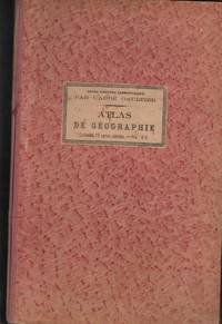
ATLAS DE GÉOGRAPHIE
by GAULTIER, L'Abbé (Aloisius Edouard Camille) (1746-1818)
- Used
- Hardcover
- Condition
- Used - Bom / Good / Bon
- Binding
- Hardcover
- Quantity Available
- 1
- Seller
-
Cascais, Portugal
- Item Price
-
€250.00
Show Details
Description:
Paris: Librairie Classique et D'Éducation. Editorial / Hard Cover. Bom / Good / Bon. In-fólio (435x286). 1 Vol. de 21 fls. Contém 15 cartas coloridas de dupla página em muito bom estado e com cartonagem editorial.
Item Price
€250.00
More Photos
Notes on Peking and Its Neighbourhood (Bound Offprint from The Journal of the Royal Geographical Society of London, Vol. 36 (1866))
by Lockhart, W.
- Used
- Very Good
- Hardcover
- first
- Condition
- Used - Very Good
- Jacket Condition
- No Jacket, As Issued
- Edition
- First Printing
- Binding
- Hardcover
- Quantity Available
- 1
- Seller
-
Bloomington, Indiana, United States
- Item Price
-
€187.00
Show Details
Description:
London: J. Murray / The Journal of the Royal Geographical Society of London, 1866. SCARCE pp. 128-156 (33 pages) with fold-out map - "The City of Peking from a Survey by Capt. Bouvier , of the French Engineers 1862" , . The map is Near Fine, 1" tear at right edge. In original dark blue cloth boards, gilt lettering at spine, Very Good, the boards stained and soiled, toning at end papers, German bookseller's small ticket and prior owner name front paste down. . First Printing. Cloth. Very Good/No Jacket, As Issued. 8vo - over 7¾" - 9¾" tall.
Item Price
€187.00
![Sea Chart. Duynckercke [Dunkirk].](https://d3525k1ryd2155.cloudfront.net/h/721/019/192019721.0.m.jpg)
Sea Chart. Duynckercke [Dunkirk].: Original Antique Hand coloured, copper engraved sea-chart.
by Pitt, Moses and Swart, Stephaman
- Used
- Very Good
- first
- Condition
- Used - Very Good
- Quantity Available
- 1
- Seller
-
Plymouth, Devon, United Kingdom
- Item Price
-
€237.80
Show Details
Description:
Pitt, Moses and Swart, Stephaman. Duynckercke, [Dunkirk]. Ca 1683. Hand coloured, copper engraved sea-chart. Chart size 440 x 505 mm, sheet size 580mm x 690mm. Two charts on one sheet showing the Dunkirk approaches. The larger chart from that of Blaeu's Pourtraict de la fameuse ville et havre de Duynckercke. With Rhumb lines, compass rose and scales. Townships and sandbanks indicated. Decorated with fleets of galleons off shore. With an inset panorama of Duynckercke [Dunkirk] after Jan Van Loon and a smaller coastal profile of Cales. The smaller chart showing the coast of Flanders, from Walchren [ Walcheren ] to Boloigne. Early hand coloured charts with later red ruled border on wide blank margins. Small tear without loss to lower blank margin, otherwise in bright and clean condition. Rare and attractive Sea Charts.
Item Price
€237.80

More Photos
Handy Map & Guide to London with index to Streets (Cruchley's Handy Map of London)
by No Author
- Used
- Very Good
- Paperback
- Condition
- Used - Very Good
- Binding
- Paperback
- Quantity Available
- 1
- Seller
-
Southampton, Hampshire, United Kingdom
- Item Price
-
€267.53
Show Details
Description:
Gall & Inglis', 1870's-1880's. Paperback. Very good. VGC.Gall & Inglis'.No date given but probably 1870's to 1880's prior to London Tower Bridge build, which is not included on the map.Green hardback(small dents,nicks and light shelf wear on the cover) with folded map in VGC.The map is in VGC but with small stain marks and foxing marks on the edges,small tear on the edge of the map.The map is hand coloured and includes:Railways,Railway Stations,Steamer Routes,Omnibus and Tramway Routes,Parks.The size of the map is: 30x20 inch.The scale of the map is: 3 3/4 to 1 mile.The map covers: From Hyde Park(including parts of Kensington Palace) to Blackwall and from Mildmay Park to South Lambeth.The map is in VGC for its age. A collectable and scarce map.
Item Price
€267.53
![Blatt 8 (VIII) : Aarau - Luzern Zug - Zürich [Zurich] : Topographische Karte der Schweiz :...](https://d3525k1ryd2155.cloudfront.net/h/777/796/330796777.0.m.jpg)
More Photos
Blatt 8 (VIII) : Aarau - Luzern Zug - Zürich [Zurich] : Topographische Karte der Schweiz : Massstab 1 : 100,000, Vermessen und herausgegeben unter Aufsicht von General G. H. Dufour
by Dufour, General G. H. [Guillaume-Henri]
- Used
- Hardcover
- Condition
- Used - Very Good (somewhat spotted)
- Edition
- 1861 edition
- Binding
- Hardcover
- Quantity Available
- 1
- Seller
-
Henderson, Nevada, United States
- Item Price
-
€163.62
Show Details
Description:
Bern [Switzerland]: Hans Körber [Koerber] (Huber & Comp.), 1861. Very Good condition. SEE PHOTOS. Karten etwas fleckig (maps somewhat spotted). This is Blatt VIII, Aarau - Luzern Zug - Zürich [Zurich]. The map is dated 1861 and has 21 sections. It is printed on paper, then mounted on cloth (i.e. backed with linen). When folded the map measures 19 cm tall x 11 cm wide. When unfolded, 57 cm tall x 79 cm wide. SEE PHOTOS. Linen-backed, steel-engraved folding map in 21 segments. Scale 1:100,000.. 1861 edition. Hardcover. Very Good (somewhat spotted).
Item Price
€163.62

More Photos
Capt. John Mason; the Founder of New Hampshire; Including his Tract on Newfoundland, 1620; the American Charters in which he was a Grantee; with Letters and Other Historical Documents; together with a Memoir by Charles Wesley Tuttle
by John Ward Dean
- Used
- Fine
- Hardcover
- Condition
- Used - Fine
- Edition
- Limited Edition
- Binding
- Hardcover
- Quantity Available
- 1
- Seller
-
Fort Lauderdale, Florida, United States
- Item Price
-
€280.50
Show Details
Description:
1 of only 250 copies. Recent green faux morocco with original wrappers bound in. Particulars in gilt to spine. Fold out map of Newfoundland. A very nice, clean copy without previous owners' names or other markings. ; 8vo 8" - 9" tall; xii; 492 pages; All shipments through USPS insured Priority Mail.
Item Price
€280.50

More Photos
Arab navigation in the Indian Ocean before the coming of the Portuguese
by Ahmad ibn Majid al-Sadi , G.R. Tibbetts
- Used
- Hardcover
- first
- Condition
- New
- Edition
- First Edition
- Binding
- Hardcover
- ISBN 10 / ISBN 13
- 9780718909000 / 0718909003
- Quantity Available
- 1
- Seller
-
Berg en dal, Netherlands
- Item Price
-
€240.00
Show Details
Description:
Ahmad ibn Majid al-Sadi, G.R. Tibbetts - Arab Navigation in the Indian Ocean before the coming of the Portuguese - London, The Royal Asiatic Society of Great Britain and Ireland; Luzac and Company Ltd, 1971 - First Edition - Hardcover - 614pp + 4 maps (out of 7)- 22x14 cmCondition Very Good: Cover some light shelf wear, inside as new. Four out of seven maps present: Chart of the Arabian Sea, India and the Bay of Bengal, Red Sea and Gulf of Eden, East African CoastIf you have any questions or want to see more pictures, feel free to ask.Your book will be securely packed and shipped with tracking number, signed & insured.
Item Price
€240.00

Stock Photo: Cover May Be Different
How to Build a Beowulf: A Guide to the Implementation and Application of PC Clusters (Scientific and Engineering Computation)
by Savarese, Daniel F.; Becker, Donald J.; Salmon, John; Sterling, Thomas
- Used
- Good
- Paperback
- Condition
- Used - Good
- Binding
- Paperback
- ISBN 10 / ISBN 13
- 9780262692182 / 026269218X
- Quantity Available
- 1
- Seller
-
Memphis, Tennessee, United States
- Item Price
-
€5.11
Show Details
Description:
MIT Press, 1999-05-28. Paperback. Good. 9x7x0.
Item Price
€5.11
Stock Photo: Cover May Be Different
How to Build a Beowulf : A Guide to the Implementation and Application of PC Clusters
by Donald J. Becker; Daniel F. Savarese; Thomas L. Sterling; John Salmon
- Used
- Acceptable
- Paperback
- Condition
- Used - Acceptable
- Binding
- Paperback
- ISBN 10 / ISBN 13
- 9780262692182 / 026269218X
- Quantity Available
- 1
- Seller
-
Seattle, Washington, United States
- Item Price
-
€5.60
Show Details
Description:
MIT Press, 1999. Paperback. Acceptable. Disclaimer:A readable copy. All pages are intact, and the cover is intact. Pages can include considerable notes-in pen or highlighter-but the notes cannot obscure the text.
Item Price
€5.60

How to Build a Beowulf : A Guide to the Implementation and Application of PC Clusters
by Donald J. Becker; William Gropp; Daniel F. Savarese; Thomas L. Sterling; John Salmon
- Used
- Good
- Paperback
- Condition
- Used - Good
- Binding
- Paperback
- ISBN 10 / ISBN 13
- 9780262692182 / 026269218X
- Quantity Available
- 2
- Seller
-
Seattle, Washington, United States
- Item Price
-
€5.60
Show Details
Description:
MIT Press, 1999. Paperback. Good. Pages can have notes/highlighting. Spine may show signs of wear. ~ ThriftBooks: Read More, Spend Less.Dust jacket quality is not guaranteed.
Item Price
€5.60
Stock Photo: Cover May Be Different
How to Build a Beowulf: A Guide to the Implementation and Application of PC Clusters (Scientific and Engineering Computation)
by Savarese, Daniel F.,Becker, Donald J.,Salmon, John,Sterling, Thomas
- Used
- Very Good
- Paperback
- Condition
- Used - Very Good
- Binding
- Paperback
- ISBN 10 / ISBN 13
- 9780262692182 / 026269218x
- Quantity Available
- 1
- Seller
-
Simi Valley, California, United States
- Item Price
-
€1.87
Show Details
Description:
The MIT Press, 5/28/1999 12:00:01 A. paperback. Very Good. 0.7000 8.9000 7.9000.
Item Price
€1.87
Stock Photo: Cover May Be Different
How to Build a Beowulf : A Guide to the Implementation and Application of PC Clusters
by Salmon, John, Gropp, William, Savarese, Daniel F., Sterling, Thomas L., Becker, Donald J
- Used
- Condition
- Used - Very Good
- ISBN 10 / ISBN 13
- 9780262692182 / 026269218x
- Quantity Available
- 1
- Seller
-
Mishawaka, Indiana, United States
- Item Price
-
€6.43
Show Details
Description:
MIT Press. Used - Very Good. Former library book; may include library markings. Used book that is in excellent condition. May show signs of wear or have minor defects.
Item Price
€6.43
Stock Photo: Cover May Be Different
How to Build a Beowulf : A Guide to the Implementation and Application of PC Clusters
by Salmon, John, Gropp, William, Savarese, Daniel F., Sterling, Thomas L., Becker, Donald J
- Used
- Condition
- Used - Good
- ISBN 10 / ISBN 13
- 9780262692182 / 026269218x
- Quantity Available
- 1
- Seller
-
Mishawaka, Indiana, United States
- Item Price
-
€6.43
Show Details
Description:
MIT Press. Used - Good. Used book that is in clean, average condition without any missing pages.
Item Price
€6.43
Stock Photo: Cover May Be Different
How to Build a Beowulf : A Guide to the Implementation and Application of PC Clusters
by Salmon, John, Gropp, William, Savarese, Daniel F., Sterling, Thomas L., Becker, Donald J
- Used
- Condition
- Used - Very Good
- ISBN 10 / ISBN 13
- 9780262692182 / 026269218x
- Quantity Available
- 1
- Seller
-
Mishawaka, Indiana, United States
- Item Price
-
€6.43
Show Details
Description:
MIT Press. Used - Very Good. Used book that is in excellent condition. May show signs of wear or have minor defects.
Item Price
€6.43
Stock Photo: Cover May Be Different
How to Build a Beowulf: A Guide to the Implementation and Application of PC Clusters (Scientific and Engineering Computation)
by Thomas Sterling; Daniel F. Savarese; Donald J. Becker; John Salmon
- Used
- Paperback
- Condition
- Used: Good
- Binding
- Paperback
- ISBN 10 / ISBN 13
- 9780262692182 / 026269218X
- Quantity Available
- 1
- Seller
-
HOUSTON, Texas, United States
- Item Price
-
€6.99
Show Details
Description:
The MIT Press, 1999-05-28. Paperback. Used: Good.
Item Price
€6.99
Stock Photo: Cover May Be Different
How to Build a Beowulf: A Guide to the Implementation and Application of PC Clusters (Scientific and Engineering Computation)
by Savarese, Daniel F., Becker, Donald J., Salmon, John, Sterling, Thomas
- Used
- Condition
- Used - Good
- ISBN 10 / ISBN 13
- 9780262692182 / 026269218x
- Quantity Available
- 1
- Seller
-
Frederick, Maryland, United States
- Item Price
-
€5.05
Show Details
Description:
The MIT Press. Used - Good. Good condition. A copy that has been read but remains intact. May contain markings such as bookplates, stamps, limited notes and highlighting, or a few light stains.
Item Price
€5.05

Hajar Bin Humeid: Investigations at a Pre-Islamic Site in South Arabia
by Van Beek, Gus W. ; Jamme, Albert ; Salmon, Maurice E. ; Al Kital, Rahim A. ; Chan, Lui-Heung ; Sayre, Edward V. ; Soderstrom, Thomas R. ; Melson, William G. Phillips, Wendell
- Used
- Fine
- Hardcover
- Condition
- Used - Fine
- Jacket Condition
- near fine
- Binding
- Hardcover
- Quantity Available
- 1
- Seller
-
Pittsburgh, Pennsylvania, United States
- Item Price
-
€8.60
Show Details
Description:
Baltimore, Maryland: Johns Hopkins Press, 1969. Hardcover. Fine/near fine. 1969, Edition not stated, likely the First Edition. Hardcover, an Imperial Octavo (8.5 x 11.10 inches ), in Very Good condition, with abrasions at two corners. PAGES: 421. Illustrated throughout with plan views of excavations, detailed drawings of artifacts, and numerous black and white excavation photographs.
Item Price
€8.60

More Photos
The Sky and the Forest
by Forester, C.S
- Used
- Very Good
- Hardcover
- first
- Condition
- Used - Very Good
- Jacket Condition
- Very Good
- Edition
- First Edition
- Binding
- Hardcover
- Quantity Available
- 1
- Seller
-
Salem, Oregon, United States
- Item Price
-
€32.62€16.32Save €17.44!
Show Details
Description:
C.S. Forester: The Sky and the Forest. Little, Brown and Company, Boston. Stated First Edition First Printing Thus August, 1948. Cover price $2.75. Used. VG BOOK/VG UNCLIPPED DUST JACKET. A story of a central Africa. By C.S. Forester, author of the Admiral Hornblower series.
Item Price
€32.62€16.32
Save €17.44
!

More Photos
Plat Book: Pierce County, Wisconsin
by Rhame, A. E
- Used
- Fine
- Paperback
- Condition
- Used - Fine
- Binding
- Paperback
- Quantity Available
- 1
- Seller
-
Woodruff, Wisconsin, United States
- Item Price
-
€43.63
Show Details
Description:
1930. Soft Cover. Fine. Unpaginated. Tan colored book is in Fine condition, no sign of wear.
Item Price
€43.63
![Alaska and Klondike Region; [With inset of Klondike Region on the Upper Yukon detail] [From an...](https://d3525k1ryd2155.cloudfront.net/h/062/537/1339537062.0.m.jpg)
Alaska and Klondike Region; [With inset of Klondike Region on the Upper Yukon detail] [From an atlas, "Gazetteer of Alaska and Yukon Region " pp. 105 and 106]
by Miller, J. Martin
- Used
- Very Good
- Condition
- Used - Very Good
- Edition
- Unknown
- Quantity Available
- 1
- Seller
-
Sebastopol, California, United States
- Item Price
-
€36.46
Show Details
Description:
Chicago: J. Martin Miller, 1899. Unknown. Map. Very Good. [Map copyright 1899, printing date of Atlas later] [19.875x15.125in]; Colored map of Alaska with steamer routes from Portland and Seattle, insets of the Klondike Region on the Upper Yukon and Western portion of Aleutian Islands; On verso index of places and names with two large black and white images; Age toning to all edges, water stain marks on bottom, slight printing offset of colors, small chips and closed tears to lower edge;.
Item Price
€36.46

Last Tales
by Dinesen, Isak
- Used
- Very Good
- Hardcover
- first
- Condition
- Used - Very Good
- Jacket Condition
- Good+
- Edition
- First Edition
- Binding
- Hardcover
- Quantity Available
- 1
- Seller
-
Salem, Oregon, United States
- Item Price
-
€112.20€56.10Save €60.00!
Show Details
Description:
Dinesen, Isak: Last Tales, A Collection of Twelve New Tales of Compelling Beauty 1957, Random House. First Edition. Stated First Printing Thus. Used. Very Good/Good+ original red dust jacket, price-clipped. Jacket states 11/57 on front flap. 5 3/4 X
Item Price
€112.20€56.10
Save €60.00
!

Zemepis Sveta - Monsunova Asie
by De La Blache, P. Vidal; Gallois, L
- Used
- Hardcover
- Condition
- Used - Very Good Condition
- Jacket Condition
- No Dust Jacket
- Binding
- Hardcover
- Quantity Available
- 1
- Seller
-
Oak Point, Texas, United States
- Item Price
-
€56.10
Show Details
Description:
Aventinum, Prague, Czechoslovakia, 1931. Hardcover. Very Good Condition/No Dust Jacket. Text entirely in Czech. Geography book on Asia with numerous photographs and maps. 1930 edition also available. Size: 4mo - over 9 3/4" - 12" tall. 400 pp. Pages are yellowed, but are tight and clean. Moderate shelfwear along the spine. Corners are lightly bumped. Quantity Available: 1. Shipped Weight: 3-5 pounds. Category: Travel & Places; Non-English Language::Czech; Pictures of this item not already displayed here available upon request. Inventory No: 001228. . Additional shipping charges may apply.
Item Price
€56.10

Zemepis Sveta - Monsunova Asie
by De La Blache, P. Vidal; Gallois, L
- Used
- Hardcover
- Condition
- Used - Very Good Condition
- Jacket Condition
- No Dust Jacket
- Binding
- Hardcover
- Quantity Available
- 1
- Seller
-
Oak Point, Texas, United States
- Item Price
-
€56.10
Show Details
Description:
Aventinum, Prague, Czechoslovakia, 1930. Hardcover. Very Good Condition/No Dust Jacket. Text entirely in Czech. Geography book on Asia with numerous photographs and maps. 1931 edition also available. Size: 4mo - over 9 3/4" - 12" tall. 400 pp. Pages are yellowed, but are tight and clean. Moderate shelfwear along the spine. Corners are lightly bumped. Quantity Available: 1. Shipped Weight: 3-5 pounds. Category: Travel & Places; Non-English Language::Czech; Pictures of this item not already displayed here available upon request. Inventory No: 001227. . Additional shipping charges may apply.
Item Price
€56.10

The Adventure of Wrangel Island
by Vilhjalmur Stefansson
- Used
- Good
- Hardcover
- first
- Condition
- Used - Good
- Jacket Condition
- No DJ Included
- Edition
- First Edition
- Binding
- Hardcover
- Quantity Available
- 1
- Seller
-
Salem, Oregon, United States
- Item Price
-
€116.77€58.39Save €62.44!
Show Details
Description:
The Adventure of Wrangel Island, Alaska (1925 Macmillan 1st Edition) HISTORY OF ALASKA. EXLIB. Good Condition/ No DJ included. Fold-out map affixed to binding at the back of the book has never been opened. The story of the (unsuccessful) attempted colonization of Wrangel Island Alaska. 413 pages plus appendix, Index. Titling is still bright. A clean, solid copy. Scarce.
Item Price
€116.77€58.39
Save €62.44
!

Seven Pillars Of Wisdom, A Triumph
by Lawrence, T.E
- Used
- Good
- Hardcover
- first
- Condition
- Used - Good
- Jacket Condition
- No DJ Included
- Edition
- First American Edition
- Binding
- Hardcover
- Quantity Available
- 1
- Seller
-
Salem, Oregon, United States
- Item Price
-
€116.83€58.42Save €62.47!
Show Details
Description:
T.E. Lawrence. SEVEN PILLARS OF WISDOM, A TRIUMPH. AUTOBIOGRAPHY. Privately Printed, 1926. First Published for general circulation 1935. First American Edition. States MCMXXXVI on the title page. Doubleday, Doran & Company, Inc. Garden City, NY. GOOD CONDITION/ NO DUST JACKET IS INCLUDED. 672 pages, indexed. Beige buckram boards. Spine has darkened a bit. 6 7/8 X 9 ½.
Item Price
€116.83€58.42
Save €62.47
!

North America from the Best Authorities, Russell, ca.1800
by Russell
- Used
- Condition
- Used
- Quantity Available
- 1
- Seller
-
Plymouth, Devon, United Kingdom
- Item Price
-
€23.78
Show Details
Description:
Russell, J. : A General Map of North America from the Best Authorities. Nd but ca.1800. From "A New Geographical, Historical and Commercial Grammar and Present State of Several Kingdoms of the World." Copper engraving. Size approx 200 x 230mm. Two neat folds. Some age colouring to edges, otherwise very clean and bright.
Item Price
€23.78

Asia from the Best Authorities, Russell, ca.1800
by Russell
- Used
- Condition
- Used
- Quantity Available
- 1
- Seller
-
Plymouth, Devon, United Kingdom
- Item Price
-
€23.78
Show Details
Description:
Russell, J. : Asia from the Best Authorities. Nd but ca.1800. From "A New Geographical, Historical and Commercial Grammar and Present State of Several Kingdoms of the World". Copper engraving. Size approx 200 x 230mm. Two neat folds. Some age colouring to edges, otherwise clean and bright. Includes Arabia, India, Borneo, Japan, China and eastern Russia.
Item Price
€23.78