Click for full-size.


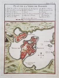
Plan de la ville de Boston.
by [Boston.] Bellin, Jacques Nicolas
- Used
- Condition
- See description
- Seller
-
Scarborough, Maine, United States
Payment Methods Accepted
About This Item
Classic Map of Boston from 1764
A classic map of Boston and the immediately surrounding area published just after the French & Indian War. The map appeared in Bellin's Petit Atlas Maritime in 1764. A 16-item legend above the map identifies various public buildings, churches and fortifications.
Condition: Very good. Clear, dark impression with attractive hand color. Age toning at the edges. Wide margins. Crease in lower right margin outside of platemark.
[ICN 7512.3]
Reviews
(Log in or Create an Account first!)
Details
- Seller
- BICKERSTAFF'S BOOKS, MAPS &C.
 (US)
(US)
- Seller's Inventory #
- 3770
- Title
- Plan de la ville de Boston.
- Author
- [Boston.] Bellin, Jacques Nicolas
- Book Condition
- Used
- Quantity Available
- 1
- Publisher
- from Petite Atlas Maritime
- Place of Publication
- [Paris.]
- Date Published
- [1764.]
- Size
- 8 ½ x 6” plus margins.
- Weight
- 0.00 lbs
Terms of Sale
BICKERSTAFF'S BOOKS, MAPS &C.
30 day return guarantee, with full refund including original shipping costs for up to 30 days after delivery if an item arrives misdescribed or damaged.
About the Seller
BICKERSTAFF'S BOOKS, MAPS &C.
Biblio member since 2020
Scarborough, Maine
About BICKERSTAFF'S BOOKS, MAPS &C.
Since 1980 we have had the pleasure of offering interesting American books, maps and ephemera to discerning collectors and institutional clients. We would be happy to assist in fulfilling your collecting or acquisition needs. Please let us know how we can help.
Glossary
Some terminology that may be used in this description includes:
- Edges
- The collective of the top, fore and bottom edges of the text block of the book, being that part of the edges of the pages of a...

Collecting Books on NYC
This gallery is dedicated to some of the best fiction and nonfiction portraying one of the greatest cities in the world. We Heart NYC! Enjoy browsing these books on New York City.

Collecting Children’s Literature
Children’s books are among some of the most popular themes to build a book collection on. Learn a bit more in our Brief History of Children’s Literature.