Description:
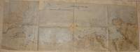
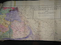
Jammer & Gilgit Agency, 1940 Government of Pakistan Full color Map 1 Inch = 16 miles. Extremely RARE OCLC locates 0 copies. 0 copies LOC. Oblong, no tears, or markings.. Oblong. 1st Edition. Soft cover. Very Good.
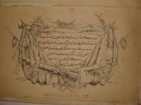
Ottoman manuscript maritime/naval map (the coastal map from Basra to Qatar by the Ottoman naval survey. Together with a printed report by the Ottoman ministry of foreign affairs: the question of the Qatar coasts ) by The Ottoman naval survey - 1908
by The Ottoman naval survey
Ottoman manuscript maritime/naval map (the coastal map from Basra to Qatar by the Ottoman naval survey. Together with a printed report by the Ottoman ministry of foreign affairs: the question of the Qatar coasts )
by The Ottoman naval survey
- Used
- very good
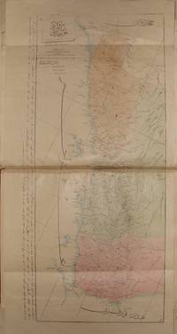
1908 Map. Very Good. No Binding. Detailed Ottoman manuscript coastal map on silk paper, 85 x 29.5 cm contains: Basra, Muhammara, Kuwait islands (with the location of an assumed rail road beginning from Umm Qasr), Kuwait, and its harbours, Eastern Nejd and its islands with some details of Beni Khalid tribe and the distances between the locations, Bahrain, and Qatar. The coasts section contains the gulf depth and distance measurements. Very rare Ottoman manuscript map of Kuwait, eastern Nejd, Bahrain and Qatar by an Ottoman surveyor in 1908.
-
Seller
Archive
 (SA)
(SA)
- Book Condition Used - Very Good
- Date Published 1908
- Keywords ottoman,turkey,turkish,turc,turque,turqiue,middle east,orient,oriental,orientale,survey,ottomano,ottomane,naval,maritime,map,manuscript,manuscrit,political,politique,policy,military,militair,militaire,nejd,najd,coast,coastal,gulf,qatar,kuwait,bahrain,abu,
Survey of Pakistan Kashmir
- Used
- very good
- Paperback
- first
- Condition
- Used - Very Good
- Edition
- 1st Edition
- Binding
- Paperback
- Quantity Available
- 1
- Seller
-
Bath, Maine, United States
- Item Price
-
€920.91
Show Details
Item Price
€920.91
More Photos
OTTOMAN ATLAS CONTAINS THIRTY NINE HAND COLORED MAPS PREPARED AND PRINTED IN THE MUHENDISHANE I BERRI HUMAYUN (THE ROYAL SCHOOL OF MILITARY ENGNEERING) IN ISTANBUL. POSSIBLY THE FIRST ADMINISTRATIVE ATLAS TO BE PRINTED IN USKUDAR AFTER THE ESTABLISHMENT OF THE TELEGRAPH LINES IN THE OTTOMAN WILAYAS (STATES)
by THE OTTOMAN AUTHORITY
- Used
- very good
- Hardcover
- Signed
- Condition
- Used - Very Good
- Binding
- Hardcover
- Quantity Available
- 1
- Seller
-
Riyadh, Saudi Arabia
- Item Price
-
€46,985.00
Show Details
Description:
Uskudar: MuhendisHane-i Berr-i Humatun (The Royal school of military engneering) Atlas. Illus. by YUMNI. Very Good. Hardcover. Folio - over 12" - 15" tall. 1860's THIRTY NINE HAND COLORED MAPS MOSTLY SIGNED BY (YUMNI). MOST OF THEM ARE DESCRIBED IN THE OTTOMAN TURKISH. ALL MAPS ON DOUBLE PAGES, TITLED AND WITH PRINTING DETAILS. LATER HARD COVER. FOLIO 40 X 28 CM. SCARCE. the maps are the followings: (1)Arabistan (Arabian peninsula) 56 x 47 cm. (2)Tarablus Gharb wa tunus (Libya and Tunisia) 56 x 39 cm. (3)Tarablus Gharb (Libya) 56 x 40 cm. (4)Misir ayalet I mumtaza si (territory of Egypt) 56 x 46 cm. (5)Yemen 69 x 33 cm. (6)Hejaz, 56 x 39 cm. (7)Ankara . (8)Sivas . (9)Ma'muat ul Aziz. (10)Diyar Bekir. (11)Bitlis. (12)Erzurum . (13)Van. (14)Mosul 56 x 39 cm. (15)Bagdad 56 x 39 cm. (16)Basra 55 x 39 cm. (17)Zor mutasarrifligi (Part of Mesopotamia. (18)Halep (Aleppo). (19)Adana. (20)Konya. (21)Kibris (Cyprus). (22)Caza'ir I Bahr I Sefid (the Wilaya of the Mediterranean sea islands). (23)Aydin. (24)Pega…
Read More Item Price
€46,985.00
More Photos
RARE OTTOMAN MILITARY MAP OF KARA DAG (MONT NEGRO)
by Ottoman General Staff Section
- Used
- very good
- Condition
- Used - Very Good
- Quantity Available
- 1
- Seller
-
Riyadh, Saudi Arabia
- Item Price
-
€4,698.50
Show Details
Description:
Istanbul: The general staff section, 1875 Map. Very Good. No Binding. Military map of Kara Dag (Mont Negro), Ottoman General staff section in 1291 (1875) after the map which made by the Austrian military geographical section in 1869 about Kara Dag and environs after the war and military movements of 1861-1862. Officially linen in colors by contemporary hands, 105 x 105 cm. Very rare..
Item Price
€4,698.50

More Photos
Tuhfet ul Kibar fi Esfar il Bihar, complete with the all maps contemporarly hand colored
by katib Celebi, Haci Halife
- Used
- Condition
- Used - Very Good+
- Quantity Available
- 1
- Seller
-
Riyadh, Saudi Arabia
- Item Price
-
€56,382.00
Show Details
Description:
complete fine copy with the 5 maps of which 4 are colored in contemporary hands.In modern fine Ottoman style binding. on The naval expeditions, printed by Ibrahim Muteferrika in 1141 H. (1728-1729).
Item Price
€56,382.00

More Photos
Avrupa-i Osmani Haritasi (Wall map of the Ottoman Europe), extra ordinary copy of an Ottoman lieutenant
- Used
- very good
- Condition
- Used - Very Good
- Quantity Available
- 1
- Seller
-
Riyadh, Saudi Arabia
- Item Price
-
€6,577.90
Show Details
Description:
205 x 137 cm. extra ordinary Ottoman wall map of the Ottoman Europe prınted ın colors, folding paper on cloth. Signatures by the first lieutenant M. İhsan.
Item Price
€6,577.90

Northern Italy, Tallis, ca.1851: Original Antique Map.
by John Tallis & Rapkin
- Used
- Condition
- Used
- Edition
- 1st Edition
- Quantity Available
- 1
- Seller
-
Plymouth, Devon, United Kingdom
- Item Price
-
€59.11
Show Details
Description:
Tallis, John: Northern Italy, London. [ca.1851]. From the Montgomery Martin Illustrated Atlas. Map engraved by Rapkin. Size approx 360 x 260mm. Original steel engraved map with original outline hand colouring. 4 vignette views including The Grand Canal Venice and St Peters Rome, Decorative border. Single page unfolded map in excellent, clean condition. Associated text page of the Montgomery Martin Atlas included. A Good Tallis Map.
Item Price
€59.11

Turkey in Asia,: Original 19th Century Map
by John Tallis and Rapkin
- Used
- very good
- Condition
- Used - Very Good
- Edition
- 1st edition
- Quantity Available
- 1
- Seller
-
Plymouth, Devon, United Kingdom
- Item Price
-
€70.93
Show Details
Description:
Tallis, John: Turkey in Asia. London. [ca.1851]. From the Montgomery Martin Illustrated Atlas. Map engraved by Rapkin. Size approx 360 x 260mm. Original steel engraved map with original outline hand colouring. 4 vignettes include Jerusalem and the Castles of Europe and Asia. The map area covers modern day Turkey, Cyprus, Israel, Lebanon, Syria, Jordan and Iraq. Decorative Border. Single page unfolded map in excellent, clean condition. Associated text page of the Montgomery Martin Atlas included.
Item Price
€70.93

Sea Chart of Milford Haven,
by Greenville Collins
- Used
- very good
- Condition
- Used - Very Good
- Edition
- Original 18th Century, Hand Coloured Sea Chart
- Quantity Available
- 1
- Seller
-
Plymouth, Devon, United Kingdom
- Item Price
-
€118.22
Show Details
Description:
Collins, Greenville : Chart of Milford Haven, from Great Britain's Coasting Pilot, ca.1760. Copper engraved chart. Map size approx 560mm x 440mm. Wide margins, hand coloured, good impression on heavy paper, showing the Welsh coast at Milford Haven. Compass rose, rhumb lines, scale. Cartouche with cherub, dedicated to Sir Hugh Owen. Light water stain to top margin just touching printed area, otherwise a very good, bright and attractive chart.
Item Price
€118.22
More Photos
OTTOMAN ATLAS CONTAINS THIRTY NINE HAND COLORED MAPS PREPARED AND PRINTED IN THE MUHENDISHANE I BERRI HUMAYUN (THE ROYAL SCHOOL OF MILITARY ENGNEERING) IN ISTANBUL. POSSIBLY THE FIRST ADMINISTRATIVE ATLAS TO BE PRINTED IN USKUDAR AFTER THE ESTABLISHMENT OF THE TELEGRAPH LINES IN THE OTTOMAN WILAYAS (STATES)
by THE OTTOMAN AUTHORITY
- Used
- very good
- Hardcover
- Signed
- Condition
- Used - Very Good
- Binding
- Hardcover
- Quantity Available
- 1
- Seller
-
Riyadh, Saudi Arabia
- Item Price
-
€46,985.00
Show Details
Description:
Uskudar: MuhendisHane-i Berr-i Humatun (The Royal school of military engneering) Atlas. Illus. by YUMNI. Very Good. Hardcover. Folio - over 12" - 15" tall. 1860's THIRTY NINE HAND COLORED MAPS MOSTLY SIGNED BY (YUMNI). MOST OF THEM ARE DESCRIBED IN THE OTTOMAN TURKISH. ALL MAPS ON DOUBLE PAGES, TITLED AND WITH PRINTING DETAILS. LATER HARD COVER. FOLIO 40 X 28 CM. SCARCE. the maps are the followings: (1)Arabistan (Arabian peninsula) 56 x 47 cm. (2)Tarablus Gharb wa tunus (Libya and Tunisia) 56 x 39 cm. (3)Tarablus Gharb (Libya) 56 x 40 cm. (4)Misir ayalet I mumtaza si (territory of Egypt) 56 x 46 cm. (5)Yemen 69 x 33 cm. (6)Hejaz, 56 x 39 cm. (7)Ankara . (8)Sivas . (9)Ma'muat ul Aziz. (10)Diyar Bekir. (11)Bitlis. (12)Erzurum . (13)Van. (14)Mosul 56 x 39 cm. (15)Bagdad 56 x 39 cm. (16)Basra 55 x 39 cm. (17)Zor mutasarrifligi (Part of Mesopotamia. (18)Halep (Aleppo). (19)Adana. (20)Konya. (21)Kibris (Cyprus). (22)Caza'ir I Bahr I Sefid (the Wilaya of the Mediterranean sea islands). (23)Aydin. (24)Pega…
Read More Item Price
€46,985.00
More Photos
RARE OTTOMAN MILITARY MAP OF KARA DAG (MONT NEGRO)
by Ottoman General Staff Section
- Used
- very good
- Condition
- Used - Very Good
- Quantity Available
- 1
- Seller
-
Riyadh, Saudi Arabia
- Item Price
-
€4,698.50
Show Details
Description:
Istanbul: The general staff section, 1875 Map. Very Good. No Binding. Military map of Kara Dag (Mont Negro), Ottoman General staff section in 1291 (1875) after the map which made by the Austrian military geographical section in 1869 about Kara Dag and environs after the war and military movements of 1861-1862. Officially linen in colors by contemporary hands, 105 x 105 cm. Very rare..
Item Price
€4,698.50

More Photos
The Sky and the Forest
by Forester, C.S
- Used
- very good
- Hardcover
- first
- Condition
- Used - Very Good
- Jacket Condition
- Very Good
- Edition
- First Edition
- Binding
- Hardcover
- Quantity Available
- 1
- Seller
-
Salem, Oregon, United States
- Item Price
-
€32.79€16.40Save €17.44!
Show Details
Description:
C.S. Forester: The Sky and the Forest. Little, Brown and Company, Boston. Stated First Edition First Printing Thus August, 1948. Cover price $2.75. Used. VG BOOK/VG UNCLIPPED DUST JACKET. A story of a central Africa. By C.S. Forester, author of the Admiral Hornblower series.
Item Price
€32.79€16.40
Save €17.44
!
![Alaska and Klondike Region; [With inset of Klondike Region on the Upper Yukon detail] [From an...](https://d3525k1ryd2155.cloudfront.net/h/062/537/1339537062.0.m.jpg)
Alaska and Klondike Region; [With inset of Klondike Region on the Upper Yukon detail] [From an atlas, "Gazetteer of Alaska and Yukon Region " pp. 105 and 106]
by Miller, J. Martin
- Used
- very good
- Condition
- Used - Very Good
- Edition
- Unknown
- Quantity Available
- 1
- Seller
-
Sebastopol, California, United States
- Item Price
-
€36.65
Show Details
Description:
Chicago: J. Martin Miller, 1899. Unknown. Map. Very Good. [Map copyright 1899, printing date of Atlas later] [19.875x15.125in]; Colored map of Alaska with steamer routes from Portland and Seattle, insets of the Klondike Region on the Upper Yukon and Western portion of Aleutian Islands; On verso index of places and names with two large black and white images; Age toning to all edges, water stain marks on bottom, slight printing offset of colors, small chips and closed tears to lower edge;.
Item Price
€36.65

Zemepis Sveta - Monsunova Asie
by De La Blache, P. Vidal; Gallois, L
- Used
- Hardcover
- Condition
- Used - Very Good Condition
- Jacket Condition
- No Dust Jacket
- Binding
- Hardcover
- Quantity Available
- 1
- Seller
-
Oak Point, Texas, United States
- Item Price
-
€56.38
Show Details
Description:
Aventinum, Prague, Czechoslovakia, 1930. Hardcover. Very Good Condition/No Dust Jacket. Text entirely in Czech. Geography book on Asia with numerous photographs and maps. 1931 edition also available. Size: 4mo - over 9 3/4" - 12" tall. 400 pp. Pages are yellowed, but are tight and clean. Moderate shelfwear along the spine. Corners are lightly bumped. Quantity Available: 1. Shipped Weight: 3-5 pounds. Category: Travel & Places; Non-English Language::Czech; Pictures of this item not already displayed here available upon request. Inventory No: 001227. . Additional shipping charges may apply.
Item Price
€56.38

Last Tales
by Dinesen, Isak
- Used
- very good
- Hardcover
- first
- Condition
- Used - Very Good
- Jacket Condition
- Good+
- Edition
- First Edition
- Binding
- Hardcover
- Quantity Available
- 1
- Seller
-
Salem, Oregon, United States
- Item Price
-
€112.76€56.38Save €60.00!
Show Details
Description:
Dinesen, Isak: Last Tales, A Collection of Twelve New Tales of Compelling Beauty 1957, Random House. First Edition. Stated First Printing Thus. Used. Very Good/Good+ original red dust jacket, price-clipped. Jacket states 11/57 on front flap. 5 3/4 X
Item Price
€112.76€56.38
Save €60.00
!

Zemepis Sveta - Monsunova Asie
by De La Blache, P. Vidal; Gallois, L
- Used
- Hardcover
- Condition
- Used - Very Good Condition
- Jacket Condition
- No Dust Jacket
- Binding
- Hardcover
- Quantity Available
- 1
- Seller
-
Oak Point, Texas, United States
- Item Price
-
€56.38
Show Details
Description:
Aventinum, Prague, Czechoslovakia, 1931. Hardcover. Very Good Condition/No Dust Jacket. Text entirely in Czech. Geography book on Asia with numerous photographs and maps. 1930 edition also available. Size: 4mo - over 9 3/4" - 12" tall. 400 pp. Pages are yellowed, but are tight and clean. Moderate shelfwear along the spine. Corners are lightly bumped. Quantity Available: 1. Shipped Weight: 3-5 pounds. Category: Travel & Places; Non-English Language::Czech; Pictures of this item not already displayed here available upon request. Inventory No: 001228. . Additional shipping charges may apply.
Item Price
€56.38

The Adventure of Wrangel Island
by Vilhjalmur Stefansson
- Used
- good
- Hardcover
- first
- Condition
- Used - Good
- Jacket Condition
- No DJ Included
- Edition
- First Edition
- Binding
- Hardcover
- Quantity Available
- 1
- Seller
-
Salem, Oregon, United States
- Item Price
-
€117.36€58.68Save €62.44!
Show Details
Description:
The Adventure of Wrangel Island, Alaska (1925 Macmillan 1st Edition) HISTORY OF ALASKA. EXLIB. Good Condition/ No DJ included. Fold-out map affixed to binding at the back of the book has never been opened. The story of the (unsuccessful) attempted colonization of Wrangel Island Alaska. 413 pages plus appendix, Index. Titling is still bright. A clean, solid copy. Scarce.
Item Price
€117.36€58.68
Save €62.44
!

Seven Pillars Of Wisdom, A Triumph
by Lawrence, T.E
- Used
- good
- Hardcover
- first
- Condition
- Used - Good
- Jacket Condition
- No DJ Included
- Edition
- First American Edition
- Binding
- Hardcover
- Quantity Available
- 1
- Seller
-
Salem, Oregon, United States
- Item Price
-
€117.42€58.71Save €62.47!
Show Details
Description:
T.E. Lawrence. SEVEN PILLARS OF WISDOM, A TRIUMPH. AUTOBIOGRAPHY. Privately Printed, 1926. First Published for general circulation 1935. First American Edition. States MCMXXXVI on the title page. Doubleday, Doran & Company, Inc. Garden City, NY. GOOD CONDITION/ NO DUST JACKET IS INCLUDED. 672 pages, indexed. Beige buckram boards. Spine has darkened a bit. 6 7/8 X 9 ½.
Item Price
€117.42€58.71
Save €62.47
!

Asia from the Best Authorities, Russell, ca.1800
by Russell
- Used
- Condition
- Used
- Quantity Available
- 1
- Seller
-
Plymouth, Devon, United Kingdom
- Item Price
-
€23.64
Show Details
Description:
Russell, J. : Asia from the Best Authorities. Nd but ca.1800. From "A New Geographical, Historical and Commercial Grammar and Present State of Several Kingdoms of the World". Copper engraving. Size approx 200 x 230mm. Two neat folds. Some age colouring to edges, otherwise clean and bright. Includes Arabia, India, Borneo, Japan, China and eastern Russia.
Item Price
€23.64

North America from the Best Authorities, Russell, ca.1800
by Russell
- Used
- Condition
- Used
- Quantity Available
- 1
- Seller
-
Plymouth, Devon, United Kingdom
- Item Price
-
€23.64
Show Details
Description:
Russell, J. : A General Map of North America from the Best Authorities. Nd but ca.1800. From "A New Geographical, Historical and Commercial Grammar and Present State of Several Kingdoms of the World." Copper engraving. Size approx 200 x 230mm. Two neat folds. Some age colouring to edges, otherwise very clean and bright.
Item Price
€23.64
![MAP OF UTAH [Territory]](https://d3525k1ryd2155.cloudfront.net/h/836/461/1485461836.0.m.jpg)
More Photos
MAP OF UTAH [Territory]
- Used
- Condition
- Used - Very Good-
- Edition
- Original
- Quantity Available
- 1
- Seller
-
Williamsburg, Virginia, United States
- Item Price
-
€61.08
Show Details
Description:
New York, Richmond, Chicago, & Toledo: H. H. Hardesty, 1885. Original color lithographed map printed by Rand, McNally & Company, Engravers and published in HARDESTY'S HISTORICAL AND GEOGRAPHICAL ENCYCLOPEDIA: SPECIAL VIRGINIA EDITION. 19 3/8 inches by 13 1/4 inches on a 21" X 14 1/2" sheet. The map depicts the Territory of Utah in its final form--large areas had been removed and ceded to Nevada, Colorado, Wyoming, and Nebraska since Utah became a U. S. Territory in 1850. The issue of polygamy prevented statehood until it was finally granted in 1896. This map features railroads and topography and uses color to set off counties from each other. Unlike most atlas maps of the period, this map identifies most small towns. The map is guaranteed to be moe than 135 years old. The map is in about very good condition: generally clean and bright, with slight toning of paper and one faint water stain near the center-left edge of the map.. Original. Single Sheet. Very Good-. Elephant…
Read More Item Price
€61.08
