Ordnance Survey road map of Caernarvon, Bangor and Colwyn Bay: sheet 11 by Anon - 1928
by Anon
Ordnance Survey road map of Caernarvon, Bangor and Colwyn Bay: sheet 11
by Anon
- Used
- very good
- Paperback
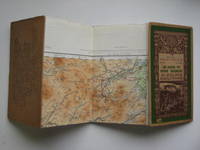
Ordnance Survey. Very Good. 1928. Reprint. Softcover. Foldout map, 1 mile to 1/2 inch, with pictorial green card covers (11 x 19 cm) which are rubbed at the edges. Opens out to 56 x 76 cm, linen backed map in very good condition with no tears or inscriptions. .
-
Seller
Aucott & Thomas
 (GB)
(GB)
- Format/Binding Softcover
- Book Condition Used - Very Good
- Edition Reprint
- Binding Paperback
- Publisher Ordnance Survey
- Date Published 1928
- Keywords Maps and mapping, Snowdonia, Anglesey
