Description:
Soft Cover. Poor. Second Edition The War to 3-31-44, Fighting Forces Series, Infantry Journal
Military Maps Illustrating the Operations of the Armies of the Potomac & James, May 4th, 1864, to April 9th, 1865, Including Battlefields of the Wilderness, Spottsylvania, North Anna, Totopotomoy, Cold Harbor, the Siege of Petersburg and Richmond, Battlefield of Five Forks, Jetersville & Sailor's Creek, Highbridge, Farmville & Appomattox Court-House by (Civil War) United States, War Department - 1869
by (Civil War) United States, War Department
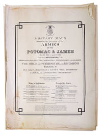
Military Maps Illustrating the Operations of the Armies of the Potomac & James, May 4th, 1864, to April 9th, 1865, Including Battlefields of the Wilderness, Spottsylvania, North Anna, Totopotomoy, Cold Harbor, the Siege of Petersburg and Richmond, Battlefield of Five Forks, Jetersville & Sailor's Creek, Highbridge, Farmville & Appomattox Court-House
by (Civil War) United States, War Department
- Used
- first
Washington, D.C.: War Department, Office of the Chief of Engineers [Lithographed by Julius Bien, New York], 1869. First Edition. Prepared under the direction of Bvt. Brig. Gen. N. Michler, Major of Engineers, and Bvt. Lieut. Col. P.S. Michie, Capt. of Engineers. 16 maps on 17 sheets. All but one double-page. Folio (23-5/8 x 18-1/2 inches). Unbound sheets. Light stains at top edges of several maps, title with tape repair. First Edition. Prepared under the direction of Bvt. Brig. Gen. N. Michler, Major of Engineers, and Bvt. Lieut. Col. P.S. Michie, Capt. of Engineers. 16 maps on 17 sheets. All but one double-page. Folio (23-5/8 x 18-1/2 inches). The topographic maps comprise:
1A. Gettsburg to Appomattox Court House (northern)
1B Gettysburg to Appomattox Court House (southern)
2. Fredericksburg
3. Chancellorville,
4. The Wilderness
5. Spottsylvania
6. North Anna (single page)
7. Totopotomoy
8. Cold Harbor
9.. Richmond,
10. Bermuda Hundred
11. Petersburg and Five Forks
12. Jetersville and Sailor's Creek
13. High Bridge
14. Appomattox Court House
15. Antietam
16. Harper's Ferry. Phillips Atlases 3688 (listing only 15 maps); Civil War Maps 518; Stephenson and McKee "Virginia in Maps," p. 194: "Topographers had already surveyed more than 1300 miles and issued more than 1200 maps prior to the army's passage over the Rapidan River on the night of 3-4 May, 1864, the beginning of U.S. Grant's major offensive in Virginia that led from the Battle of the Wilderness on 5 and 6 May to the ten-month siege of Petersburg beginning in mid-June and finally to R.E. Lee's surrender at Appomattox on 9 April 1865. [Bvt. Brig.-Gen. Nathaniel] Michler's men made more than 1600 photographic sketches between the time of the river crossing and 30 July 1864. The vast number of surveys that Michler directed led to the publication [of this atlas].
-
Bookseller
Independent bookstores
 (US)
(US)
- Format/Binding Prepared under the direction of Bvt. Brig. Gen. N. Michler, Major of Engineers, and Bvt. Lieut. Col. P.S. Michie, Capt. of Engin
- Book Condition Used - Unbound sheets. Light stains at top edges of several maps, title with tape repair
- Quantity Available 1
- Edition First Edition
- Publisher War Department, Office of the Chief of Engineers [Lithographed by Julius Bien, New York]
- Place of Publication Washington, D.C.
- Date Published 1869
- Keywords Civil War

War In Outline 1939-1944 Materials for the Use of Army Orientation Course
by United States War Department
- Used
- poor
- Paperback
- Condition
- Used - Poor
- Binding
- Paperback
- Quantity Available
- 1
- Seller
-
New Brighton, Minnesota, United States
- Item Price
-
€2.80
Show Details
Item Price
€2.80

Stock Photo: Cover May Be Different
War Department Technical Manual - Woodworking & Furniture Repair: U.S. War Department Manual Tm5-613, June 1946
by United States War Department
- Used
- Good
- Paperback
- Condition
- Used - Good
- Binding
- Paperback
- ISBN 10 / ISBN 13
- 9781440355066 / 1440355061
- Quantity Available
- 1
- Seller
-
Seattle, Washington, United States
- Item Price
-
€6.80
Show Details
Description:
Popular Woodworking Books, 2019. Paperback. Good. Pages can have notes/highlighting. Spine may show signs of wear. ~ ThriftBooks: Read More, Spend Less.Dust jacket quality is not guaranteed.
Item Price
€6.80
Joint Statement by The Secretary of War, The Attorney General, The Secretary of the Navy and The Chairman of the Maritime Commission on the Employment of Aliens.
by United States War Department, et al
- Used
- Condition
- Used
- Quantity Available
- 1
- Seller
-
Cleveland, Ohio, United States
- Item Price
-
€2.99
Show Details
Description:
Washington, 1943. 6 pp., self wrappers, good. - If you are reading this, this item is actually (physically) in our stock and ready for shipment once ordered. We are not bookjackers. Buyer is responsible for any additional duties, taxes, or fees required by recipient's country.
Item Price
€2.99
Table of Fundamental Allowances: Quartermaster Supplies. 1917.
by United States War Department
- Used
- Condition
- Used
- Quantity Available
- 1
- Seller
-
Cleveland, Ohio, United States
- Item Price
-
€3.40
Show Details
Description:
Washington: GPO,, 1917. 52 pp., mostly a tabular presentation but many interesting items may be gleaned e.g. motorcycle drivers were issued special aviation sweaters, division headquarters is entitled to five garbage cans while brigade headquarters gets only two, no cots are issued to mules, etc. etc, paper wrappers darkening at margins, else very good,. - If you are reading this, this item is actually (physically) in our stock and ready for shipment once ordered. We are not bookjackers. Buyer is responsible for any additional duties, taxes, or fees required by recipient's country.
Item Price
€3.40
Description of the Wind Component Indicator. Mechanical Features, Methods of Assembling and Dismounting, and Rules Governing Its Care and Preservation in Service (One Plate) ... Revised March 23, 1908.
by United States. War Department. Office of the Chief of Ordnance
- Used
- Condition
- Used
- Quantity Available
- 1
- Seller
-
Cleveland, Ohio, United States
- Item Price
-
€4.15
Show Details
Description:
Washington: GPO,, 1917. 6 pp., 1 folding plate; extraction roughness and chip at spine with no loss, now in self wrappers, good only. - If you are reading this, this item is actually (physically) in our stock and ready for shipment once ordered. We are not bookjackers. Buyer is responsible for any additional duties, taxes, or fees required by recipient's country.
Item Price
€4.15

Stock Photo: Cover May Be Different
Handbook on German Military Forces
by United States War Department; U S War Department; Ambrose, Stephen E
- Used
- Good
- Paperback
- Condition
- Used - Good
- Binding
- Paperback
- ISBN 10 / ISBN 13
- 9780807120118 / 0807120111
- Quantity Available
- 1
- Seller
-
Seattle, Washington, United States
- Item Price
-
€8.37
Show Details
Description:
LSU Press, 1995. Paperback. Good. Former library book; Pages can have notes/highlighting. Spine may show signs of wear. ~ ThriftBooks: Read More, Spend Less.Dust jacket quality is not guaranteed.
Item Price
€8.37
Extracts from General Orders and Bulletins, War Department, October, 1917 relating to Regimental and Company Administration
by United States war Department
- Used
- Condition
- Used
- Quantity Available
- 1
- Seller
-
Cleveland, Ohio, United States
- Item Price
-
€4.29
Show Details
Description:
Washington: GPO, 1917. 31 pp., self wrappers, hand stamp to the front cover, two small binder's stab holes near spine, else good. - If you are reading this, this item is actually (physically) in our stock and ready for shipment once ordered. We are not bookjackers. Buyer is responsible for any additional duties, taxes, or fees required by recipient's country.
Item Price
€4.29
List of Libraries, Organizations, and Educational Institutions in the Several States and Territories of the United States, supplied with the Official Records of the Union and Confederate Armies.
by United States. War Department. Record and Pension Office
- Used
- Condition
- Used
- Quantity Available
- 1
- Seller
-
Cleveland, Ohio, United States
- Item Price
-
€4.59
Show Details
Description:
Washington:, ca. 1903. 53 pp., a typed slip supplementing the Ohio section tipped in, library hand stamps, paper wrappers chipped at extremities, soft vertical fold mark, good. - If you are reading this, this item is actually (physically) in our stock and ready for shipment once ordered. We are not bookjackers. Buyer is responsible for any additional duties, taxes, or fees required by recipient's country.
Item Price
€4.59
Personal Affairs of Military Personnel and their Dependents. 1942.
by United States War Department
- Used
- Condition
- Used
- Quantity Available
- 1
- Seller
-
Cleveland, Ohio, United States
- Item Price
-
€5.04
Show Details
Description:
Washington: GPO,, 1942,. 46 pp, preparations needed for possible years of separation, capture, death in service, etc, self wrappers shaken, . - If you are reading this, this item is actually (physically) in our stock and ready for shipment once ordered. We are not bookjackers. Buyer is responsible for any additional duties, taxes, or fees required by recipient's country.
Item Price
€5.04
Facts of Interest concerning the Military Resources and Policy of the United States.
by United States War Department
- Used
- Condition
- Used
- Quantity Available
- 1
- Seller
-
Cleveland, Ohio, United States
- Item Price
-
€5.04
Show Details
Description:
Washington: GPO,, 1914,. 32 pp., paper wrappers chipped at extremities,. - If you are reading this, this item is actually (physically) in our stock and ready for shipment once ordered. We are not bookjackers. Buyer is responsible for any additional duties, taxes, or fees required by recipient's country.
Item Price
€5.04