
Click for full-size.
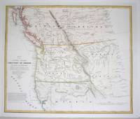
Map of the United States Territory of Oregon West of the Rocky Mountains...
by Washington Hood (1808-1840); M.H. Stansbury
- Used
- Condition
- Excellent
- Seller
-
Toronto, Ontario, Canada
Payment Methods Accepted
About This Item
Washington, U.S.A., 1838. Excellent. Notes: Map of Oregon Territory before being officially incorporated as a US Territory on August 14, 1848.
Washington Hood (February 2, 1808 – July 17, 1840) was an American (born in Philadelphia) army officer in the Corps of Topographical Engineers. He drafted maps of the American West while exploring the areas (the Ohio Michigan border; northeastern Oklahoma, Indian tribes west of Arkansas and Missouri...etc.)., Size : 443x525 (mm), 17.375x20.625 (Inches), Coloring: Hand Colored in Outline, Reference: Wheat: 433 and 434., Category: Maps Canada West British Columbia;
Washington Hood (February 2, 1808 – July 17, 1840) was an American (born in Philadelphia) army officer in the Corps of Topographical Engineers. He drafted maps of the American West while exploring the areas (the Ohio Michigan border; northeastern Oklahoma, Indian tribes west of Arkansas and Missouri...etc.)., Size : 443x525 (mm), 17.375x20.625 (Inches), Coloring: Hand Colored in Outline, Reference: Wheat: 433 and 434., Category: Maps Canada West British Columbia;
Reviews
(Log in or Create an Account first!)
Details
- Bookseller
- Alexandre Antique Prints, Maps & Books
 (CA)
(CA)
- Bookseller's Inventory #
- M4741
- Title
- Map of the United States Territory of Oregon West of the Rocky Mountains...
- Author
- Washington Hood (1808-1840); M.H. Stansbury
- Book Condition
- Used - Excellent
- Place of Publication
- Washington, U.S.A.
- Date Published
- 1838
- Keywords
- Maps Canada West British Columbia;
Terms of Sale
Alexandre Antique Prints, Maps & Books
30 day return guarantee, with full refund including original shipping costs for up to 30 days after delivery if an item arrives misdescribed or damaged.
About the Seller

Collecting History of the Circus in America
Step right up! Take a look at the center ring, where you will see displayed the most amazing, most colorful series of history books that the world has ever seen! Right this way, folks…

Collecting food and drink books
Nothing quite whets the appetite for rare and collectible books like old and vintage cookbooks. Be sure to check out our cook books and food section of our rare book room.
