Description:
Army Map Service, 1944-01-01. Paperback. Good. Good condition with wear and markings, ex-library.
Luzon Island C-40 & Southeast China No 34. AAF Cloth Chart. Philippine & Asiatic Series. by US Army, Army Map Service - 1945
by US Army, Army Map Service

Luzon Island C-40 & Southeast China No 34. AAF Cloth Chart. Philippine & Asiatic Series.
by US Army, Army Map Service
- Used
- near fine
Army Map Service, 1945. , 1945. 1944. Printed April 1945. Silk escape map. Luzon 1:1,000,000. Color. China 1943. 1:2,000,000. Printed on Both sides. Folded. Approx. 20 X26 Inches. Near Fine Copy. Map. Near Fine. Map.
-
Seller
Independent bookstores
 (US)
(US)
- Format/Binding
- Book Condition Used - Near Fine
- Publisher Army Map Service, 1945.
- Date Published 1945
- Keywords Silk escape map.
Glossary of terms used on maps of Japan May 1944 [Paperback] United States. Army Map Service
by United States. Army Map Service
- Used
- Good
- Paperback
- Condition
- Used - Good
- Binding
- Paperback
- Quantity Available
- 1
- Seller
-
San Diego, California, United States
- Item Price
-
€22.15
Show Details
Item Price
€22.15
Stock Photo: Cover May Be Different
Objective Methods for Food Evaluation: Proceedings of a Symposium, November 7-8, 1974, Newton, Massachusetts
by United States. Army Map Service
- Used
- Very Good
- Hardcover
- Condition
- Used - Very Good
- Binding
- Hardcover
- ISBN 10 / ISBN 13
- 9780309025201 / 0309025206
- Quantity Available
- 1
- Seller
-
Redondo Beach, California, United States
- Item Price
-
€28.02
Show Details
Description:
Washington, D.C.: National Academy of Sciences, 1976. Book. Very Good. Hardcover. 4to - over 9¾" - 12" tall. Hardcover 1976 library binding edition. Ex-library book with stamps and labels attached. Binding firm. Pages unmarked and clean. Covers in plain cardboard with library tape binding. [299 pages].
Item Price
€28.02

Eastport, Canada and United States Map sheet 21B 1:250,000
by U.S. Army Map Service
- Used
- fair
- Paperback
- Condition
- Used - Fair
- Binding
- Paperback
- Quantity Available
- 1
- Seller
-
Gunnislake, Cornwall, United Kingdom
- Item Price
-
€5.94
Show Details
Description:
U.S. Army Map Service, 1974. Map. Fair. Map. Flat map, which has been folded; some annotation to SE corner of map (appears to be pencil) over the NS coast, else in good condition..
Item Price
€5.94
More Photos
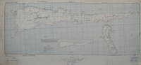
Molukken Islands, Soela Sheet No. 1 (S133-E12410/50X220), AMS T561
by US Army Map Service
- Used
- Condition
- Used
- Quantity Available
- 1
- Seller
-
Godalming, Surrey, United Kingdom
- Item Price
-
€23.78
Show Details
Description:
Army Map Service, US Army, 1943. sheet overall dimensions 510 x 1115 mm (landscape), scale 1:250,000; inset 'Sketch indicating the way the terrain was surveyed; the anchorages for the ships of K. P. M. and other large steamers, and a diagram of the low tide current close to the coast, based upon information obtained from the native population and local native sailors. Additional Information: The detail surveys, starting out from the coast line survey on Soela Sanana, were composed of observations from great distances along the coast, observing at sea towards known points along the shore and known hill and mountain tops. The altitudes were measured with an aneroid barometer, others were determined by the compass clinometer, others with level compass.' Legend includes: 'Surveyed with the compass clinometer; Measured by pacing-off and with the Smalkalder compass; estimated distances and boussole compass measurements; Surveys done by the mining engineer, Dr. H. A. Brouwer, azimuthal…
Read More Item Price
€23.78
43 K...WEST WEST PORTUGAL (NORTH)...SPAIN (NORTH WEST)..:..& SPAIN (NORTH EAST) ...FRANCE (SOUTH WEST) MAP (AERONAUTICAL CHART)..SCALE 1:1,000,000. (silk aviation escape map ww2)
by WAR DEPARTMENT (?)...us u.s. army map service
- Used
- Very Good
- Paperback
- Condition
- Used - Very Good
- Edition
- Original ed
- Binding
- Paperback
- Quantity Available
- 1
- Seller
-
Durham, California, United States
- Item Price
-
€46.70
Show Details
Description:
No Place stated pub: no publisher stated..(us u.s. army map service?). Very Good. ud 1940s?. Original ed. paperback. 23x21" folded to 3x3".. VERY GOOD Condition. CORENERS SOME ROLL PAPERBACK; (AERONAUTICAL CHART)..printed in fine detail on both sides of nice SILK CLOTH..Similar to items used in World War TWo as part of rescue & trade item for flliers first aid kits. cloth is 23x21" neatly folded down to 3x3". PORTA TO MADRID BOTTOM ONE SIDE..BILBOA to BEZIERS other side top.No date to LEGEND CHART, ...Map is on bright white silk cloth, with 1" wide tan border all around. NOT TORN, NOT FREYED, NOT MARKED UP..NOT STAINED..BUT OBVIOUSLY WORLD WAR TOW ERA ITEM. ; 1 LARGE SHEET pages; VERY LAGE, COLORFUL MAP SHOWING MUCH EUROPE SOUTH OF FRANCE...This a nice item since it covers the European theater.. Quite nice, no tears, no marks. CLEAN .
Item Price
€46.70
A.M.S. 1106. 20/4/1947/ENGR. BASE PLANT/1442.: Reproduced under the direction of the Chief of Engineers by the Army Map Service, U.S. Army, Washington, D.C., 1944.
by Army Map Service, US-Army (Editor)
- Used
- Condition
- Used
- Quantity Available
- 1
- Seller
-
Berlin, Germany
- Item Price
-
€44.00
Show Details
Description:
1944. Washington. AMS. 1944/47. (ca. 91 x 88 cm). 1 map (English Language). Original map, folded, with title to front cover. Low signs of use, a bit browning at the back. Appropriate to its age in good condition. Die vorliegende Karte beinhaltet den geographischen Stand bis 1945. Sie zeigt Europa, Asien, Afrika und den Großteil Ozeaniens. Sie trägt oben den Hinweis: "For use by War and Navy Department Agencies only". / The military map shows Europe, Asia, Africa and wide parts of Australia. The map contains the geographic status up to 1945 and contains the note "For use by War and Navy Department Agencies only".
Item Price
€44.00
Buir Nor NL 50 & Tsitsihar NL 51. AAF Cloth Chart. AMS 5301. Eastern Asia Series. Evasion Map Scarf
by US Army, Army Map Service
- Used
- first
- Condition
- Used - Very Fine
- Edition
- First Edition. 1st Printing.
- Quantity Available
- 1
- Seller
-
Hull, Massachusetts, United States
- Item Price
-
€88.73
Show Details
Description:
Washington, DC: Army Map Service, 1944. First Edition. 1st Printing.. Map. Very Fine. 25 x 22.5 x .01. Map. Condition: Very Fine. Army Map Service, Washington, DC 1944. First Edition. 1st Printing. Nice Firm Clean copy ! Map is in excellent condition. Size: 25 x 22.5 x .01. Actual WWII vintage. Worn in World War II for airplane crews who were shot down. Evasion maps. Often worn as scarfs. Rayon acetate. Maps RBR13 RBR13
Item Price
€88.73
Sendai NJ 54 & Kanazawa NJ 53. AAF Cloth Chart. AMS 5301. Eastern Asia Series. Evasion Map Scarf
by US Army, Army Map Service
- Used
- Condition
- Used - Very Fine
- Edition
- 2nd Edition.
- Quantity Available
- 1
- Seller
-
Hull, Massachusetts, United States
- Item Price
-
€88.73
Show Details
Description:
Washington, DC: Army Map Service, 1944. 2nd Edition.. Map. Very Fine. 25 x 22.5 x .01. Map. Condition: Very Fine. Army Map Service, Washington, DC 1944. 2nd Edition. Nice Firm Clean copy ! Map is in excellent condition. Size: 25 x 22.5 x .01. Actual WWII vintage. Worn in World War II for airplane crews who were shot down. Evasion maps. Often worn as scarfs. Rayon acetate. Maps Military History::Aviation Military History::WWII RBR13 RBR13
Item Price
€88.73
Pei-P'ing (Peking) NJ 50 & Ryojun NJ 51. AAF Cloth Chart. Eastern Asia Series. AMS 5301. Evasion Map Scarf
by US Army, Army Map Service
- Used
- Condition
- Used - Very Fine
- Edition
- 2nd Edition.
- Quantity Available
- 1
- Seller
-
Hull, Massachusetts, United States
- Item Price
-
€88.73
Show Details
Description:
Washington, DC: Army Map Service, 1944. 2nd Edition.. Map. Very Fine. 25 x 22.5 x .01. Map. Condition: Very Fine. Army Map Service, Washington, DC 1944. 2nd Edition. Nice Firm Clean copy ! Map is in excellent condition. Size: 25 x 22.5 x .01. Actual WWII vintage. Worn in World War II for airplane crews who were shot down. Evasion maps. Often worn as scarfs. Rayon acetate. Maps Military History::Aviation Military History::WWII RBR13 RBR13
Item Price
€88.73
Otomari NL 54 & Vladimiro-Aleksandrovskoye NK 53. AAF Cloth Chart. AMS 5301. Eastern Asia Series. Evasion Map Scarf
by US Army, Army Map Service
- Used
- Condition
- Used - Very Fine
- Edition
- 2nd Edition.
- Quantity Available
- 1
- Seller
-
Hull, Massachusetts, United States
- Item Price
-
€88.73
Show Details
Description:
Washington, DC: Army Map Service, 1944. 2nd Edition.. Map. Very Fine. 25 x 22.5 x .01. Map. Condition: Very Fine. Army Map Service, Washington, DC 1944. 2nd Edition. Nice Firm Clean copy ! Map is in excellent condition. Size: 25 x 22.5 x .01. Actual WWII vintage. Worn in World War II for airplane crews who were shot down. Evasion maps. Often worn as scarfs. Rayon acetate. Maps Military History::Aviation Military History::WWII RBR13 RBR13
Item Price
€88.73