Click for full-size.


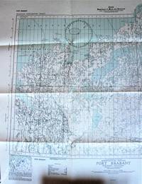
Fold-Out Topographical Survey Map. Port Brabant Northwest Territories (District of Mackenzie). Aeronautical Edition
- Used
- Very Good
- Paperback
- Condition
- Very Good
- Seller
-
Calgary, Alberta, Canada
Payment Methods Accepted
About This Item
Ottawa: Hydrographic and Map Service., 1943 Map is scale 1 inch to 8 miles with lakes shaded in blue. Measures 27" by 24" with border. Shows: Towns, settlements, trading post, RCMP, seaplane anchorage, etc. Minor wear. Very Good.
Reviews
(Log in or Create an Account first!)
Details
- Bookseller
- Ken Jackson
 (CA)
(CA)
- Bookseller's Inventory #
- 256107
- Title
- Fold-Out Topographical Survey Map. Port Brabant Northwest Territories (District of Mackenzie). Aeronautical Edition
- Format/Binding
- Soft cover
- Book Condition
- Used - Very Good
- Quantity Available
- 1
- Binding
- Paperback
- Publisher
- Hydrographic and Map Service.
- Place of Publication
- Ottawa
- Date Published
- 1943
- Weight
- 0.00 lbs
- Keywords
- CARTOGRAPHY AND MAPS FOLD-OUT TOPOGRAPHICAL SURVEY MAP. PORT BRABANT NORTHWEST TERRITORIES (DISTRICT OF MACKENZIE). AERONAUTICAL EDITION MAP CANADA
- Bookseller catalogs
- Cartography and Maps;
Terms of Sale
Ken Jackson
Any book may be returned for any reason. If not as described we will pay shipping both ways.
About the Seller
Ken Jackson
Biblio member since 2005
Calgary, Alberta
About Ken Jackson
We are a family business and have been involved in books since 1971.
This Book’s Categories

Collecting History of the Circus in America
Step right up! Take a look at the center ring, where you will see displayed the most amazing, most colorful series of history books that the world has ever seen! Right this way, folks…

Browse rare books
Interested in rare and collectible books? Booksellers from around the world showcase some of their finest in Biblio’s rare book room.
