
Click for full-size.
County Map of the State of Pennsylvania.
by Mitchell, Samuel Augustus Jr
- Used
- Condition
- See description
- Seller
-
Florham Park, New Jersey, United States
Payment Methods Accepted
About This Item
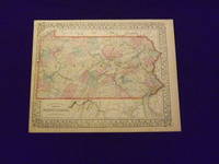
Unbound, colored engraved map, decorative boarder, 15" x 12". Slight toning and aging, margins somewhat narrow, but ample; overall bright and clear and in very good shape. Maps are wrapped with acid free board, or in rigid sleeves. The Mitchell family started to produce atlases in 1846, and continued into the early 1890s. Around 1860, S. Augustus Mitchell Jr. took over, and the atlas would be called Mitchell's New General Atlas. This is a colorful map of just the map of Pennsylvania from the 1869 installment of that atlas. While the map includes three other states, Pennsylvania is the most prominent part of the map. Insets highlight the cities of Philadelphia and Baltimore. Ristow 311-313. # 103162
Details
- Bookseller
- Nicholas D. Riccio Rare Books & Prints
 (US)
(US)
- Bookseller's Inventory #
- 103162
- Title
- County Map of the State of Pennsylvania.
- Author
- Mitchell, Samuel Augustus Jr
- Book Condition
- Used
- Quantity Available
- 1
- Place of Publication
- Philadelphia
- Date Published
- 1869.
- Keywords
- Pennsylvania.
Terms of Sale
Nicholas D. Riccio Rare Books & Prints
30 day return guarantee, with full refund including shipping costs for up to 30 days after delivery if an item arrives misdescribed or damaged.
About the Seller
Nicholas D. Riccio Rare Books & Prints
Biblio member since 2011
Florham Park, New Jersey
About Nicholas D. Riccio Rare Books & Prints
Established in 1999 we specialize in Americana, African Americana, Natural History, Travel & Exploration, Science & Medicine, and Maps & Atlases
Glossary
Some terminology that may be used in this description includes:
- New
- A new book is a book previously not circulated to a buyer. Although a new book is typically free of any faults or defects, "new"...

What is a professional bookseller?
Just about anyone can sell a book, but a professional bookseller knows the ins and outs of the rare book trade. Learn more!

Collecting Books on NYC
This gallery is dedicated to some of the best fiction and nonfiction portraying one of the greatest cities in the world. We Heart NYC! Enjoy browsing these books on New York City.