Description:
Gall & Inglis', 1870's-1880's. Paperback. Very good. VGC.Gall & Inglis'.No date given but probably 1870's to 1880's prior to London Tower Bridge build, which is not included on the map.Green hardback(small dents,nicks and light shelf wear on the cover) with folded map in VGC.The map is in VGC but with small stain marks and foxing marks on the edges,small tear on the edge of the map.The map is hand coloured and includes:Railways,Railway Stations,Steamer Routes,Omnibus and Tramway Routes,Parks.The size of the map is: 30x20 inch.The scale of the map is: 3 3/4 to 1 mile.The map covers: From Hyde Park(including parts of Kensington Palace) to Blackwall and from Mildmay Park to South Lambeth.The map is in VGC for its age. A collectable and scarce map.
Coste de Guayane, autrement France équinoctiale en la terre-ferme d'Amérique, suivant les dernières relations by Du Val, P - 1664
by Du Val, P

Coste de Guayane, autrement France équinoctiale en la terre-ferme d'Amérique, suivant les dernières relations
by Du Val, P
- Used
Paris: Chez l'auteur, 1664. Unbound map. Good+/No Jacket. Map, 27 x 34 cm. Shows the coastal area from the Orinoco to the Amazon, with an inset map of Ile de Cayenne. Legendary Lac Parime shown in southern area. Printed in black and hand colored. Creased along middle vertical fold, otherwise unworn and unmarked
-
Bookseller
Dinsmore Books
 (US)
(US)
- Format/Binding Unbound map
- Book Condition Used - Good+
- Jacket Condition No Jacket
- Quantity Available 1
- Publisher Chez l'auteur
- Place of Publication Paris
- Date Published 1664
- Product_type

More Photos
Handy Map & Guide to London with index to Streets (Cruchley's Handy Map of London)
by No Author
- Used
- very good
- Paperback
- Condition
- Used - Very good
- Binding
- Paperback
- Quantity Available
- 1
- Seller
-
Southampton, Hampshire, United Kingdom
- Item Price
-
€266.26
Show Details
Item Price
€266.26

More Photos
Portrait and Biographical Album of WILL COUNTY, ILLINOIS containing Full Page Portraits and Biographical Sketches of Prominent and Representative Citizens of the County 1890: 19th Century Geneology
by Chapman Brothers
- Used
- Hardcover
- first
- Condition
- Used - Good-
- Jacket Condition
- none
- Edition
- Later printing of the 1st edition, copyright 1885 Chapman
- Binding
- Hardcover
- Quantity Available
- 1
- Seller
-
Winfield, Illinois, United States
- Item Price
-
€235.62
Show Details
Description:
Book is in Very Good condition but the leather cover is fragile/Fair. All around gilt, spine is very worn and the hinges are cracked with the covers almost detached. 771 pages plus transportation. Also includes portraits and biographies of all the presidents of the U.S. and Governors of the State. A very large book, additional shipping outside the continental U.S.A.
Item Price
€235.62
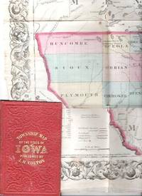
COLTON'S TOWNSHIP MAP OF THE STATE OF IOWA: Compiled from the United Statees Surveys & other Authentic Sources.; Drawn by George W. Colton. Engraved by J.M. Atwood
by Iowa
- Used
- good
- Condition
- Used - Good
- Edition
- 1855 edition
- Binding
- Unknown
- Quantity Available
- 1
- Seller
-
Roosevelt, New Jersey, United States
- Item Price
-
€282.75
Show Details
Description:
New York: J.H. Colton & Co, 1855. 1855 edition. Original Cloth. Good. Full-color engraved map, colored by hand, scrollwork border on all sides, opens to 25" x 29"; repairable separations at the intersections of several folds. Folds into red cloth case with embossed all-over design on both covers, gilt lettering on front. 5.5" x 3.75" [OCLC locates three holdings of this edition: Grinnell Col, U Iowa, Stanford U. Decker 23:225--1870 edition.].
Item Price
€282.75

More Photos
Travel and Adventure in the Territory of Alaska, 1869 First Edition
by Whymper, Frederick
- Used
- Hardcover
- first
- Condition
- Used - Very Good+
- Edition
- First
- Binding
- Hardcover
- Quantity Available
- 1
- Seller
-
Lincoln, Nebraska, United States
- Item Price
-
€293.82€264.45Save €31.17!
Show Details
Description:
Travel and Adventure in the Territory of Alaska, Formerly Russian America--Now Ceded to the United States--and in Various Other Parts of the North Pacific. By Frederick Whymper. With Map and Illustrations. New York: Harper & Brothers, Publishers, Franklin Square. 1869. First Edition.Signed by W D Fenton, founder of the Oregon Historical Society.Illustrated frontispiece with original tissue guard, fold out map, wood engravings.Condition: Good Condition. NOT a library book. Please review photos and ask for more if necessary to make your best buying decision!
*Please Note: This item will be shipped to your address of record AND will require a verified signature upon receipt. Thank you for tracking your purchase and being available to sign for it upon delivery. We appreciate your business and hope to do business with you again!
**Attention International Buyers** For all standard international book orders, we will be using Asendia consolidated shipping through Biblio.com. If you should choose expedited… Read More
Item Price
€293.82€264.45
Save €31.17
!

More Photos
NUOVA PIANTA DI FIRENZE CON L'INDICAZIONE DEI TRE DISTANTI SATI E GIRI DI Mura Che Ebbe in Diferenti Epoche. Publicata Con Privilegio Imperiale e Reale.
by FLORENCE - FIRENZE
- Used
- very good
- Condition
- Used - Very Good
- Binding
- Unknown
- Quantity Available
- 1
- Seller
-
Tel-Aviv, Israel
- Item Price
-
€329.88
Show Details
Description:
Firenze: Nella Stamperia Del Giglio, 1818. Original Cardboard. Very Good. 8vo. 28pp text and a folding map of FIRENZE 67 x 55 cm. Small 8 vo. Minimal outside wear . Some expert repair to map. A few small stains on the verso of map. OTHERWISE A VERY GOOD AND CLEAN COPY.. A RARE AND BEAUTIFUL FLAN OF FIRENZE.
Item Price
€329.88

Netherlands. Greenville Collins. 1753: Original 18th Century, Hand Coloured Sea Chart. Coast line of Flanders at Calles [Calais] to Der Scheling [Terschelling]of the West Frisian Islands and then Eastern England Margate in Kent to Burnham Flats in Norfolk. Much detail is given of the Thames es
by Greenville Collins
- Used
- very good
- Condition
- Used - Very Good
- Quantity Available
- 1
- Seller
-
Plymouth, Devon, United Kingdom
- Item Price
-
€213.01
Show Details
Description:
Collins, Capt. Greenville: Netherlands, Untitled chart of Holland, Flanders and Eastern England. Ca 1753. Copper engraved chart. Size approx 600mm x 480mm. Good margins, hand coloured, good impression on heavy paper. Coast line of Flanders at Calles [Calais] to Der Scheling [Terschelling]of the West Frisian Islands and then Eastern England Margate in Kent to Burnham Flats in Norfolk. Much detail is given of the Thames estuary and Rotterdam soundings. Depth soundings and rhumb lines indicated. A compass rose is set at the centre of the Chart. Title cartouche "To the Honourable Sir john Ashby Kt. Admiral of the Blew/ This is most humbly dedicated and presented by Capt G Collins". Some age soiling to edges, one small tear, without loss and repaired to centre fold area. A scarce, attractive sea chart in good, bright condition suitable for display.
Item Price
€213.01

More Photos
MAP OF PHILADELPHIA, CAMDEN AND VICINITY Compiled from City Plans & Personal Surveys
by Smith, Elvino V.
- Used
- Hardcover
- Condition
- Used - Good+
- Binding
- Hardcover
- Quantity Available
- 1
- Seller
-
Fairfield, New Jersey, United States
- Item Price
-
€282.75
Show Details
Description:
Philadelphia: Elvino V. Smith. Good+. 1912. Hardcover. A very large folding map (56" x 43") mounted in a light blue, lightly faded, hardcover cloth folder with gilt lettering on front. Map in nice condition except for a few tears along the folds. Folder has paper tears along interior hinges. Condition--Folder: G+, Map: VG. Pennsylvania ; Fold out Map; Thin 12mo 7" - 7½" tall .
Item Price
€282.75

More Photos
Digging the Old West: How Dams and Ditches Sculpted an American Landscape
by Franklin, Karmen Lee
- Used
- Paperback
- Condition
- Used- Fine
- Binding
- Paperback
- ISBN 10 / ISBN 13
- 9780615531489 / 0615531482
- Quantity Available
- 1
- Seller
-
Longmont, Colorado, United States
- Item Price
-
€259.19
Show Details
Description:
Franklin Design Bureau, 2011. Paperback. Used- Fine condition. Book is clean and tight. Book shows light shelf wear. Light bumping on the top and bottom of the spine. No markings on the inside of the book. Photos are of the book we have here at Barbed Wire Books."It is one of the few works that attempts fully to explain Colorado's water history. It is unusually well-written, with vivid descriptions of people, processes, events, and landscape features." Mark Fiege
Item Price
€259.19

More Photos
The northern traveller: containing the routes to Niagara, Quebec, and the Springs: with descriptions of the principal scenes and useful hints to strangers
by DWIGHT, Theodore; GILPIN, Henry D
- Used
- near fine
- Hardcover
- Condition
- Used - Near Fine
- Binding
- Hardcover
- Quantity Available
- 1
- Seller
-
COLUMBIA, Missouri, United States
- Item Price
-
€329.88
Show Details
Description:
1831 Northern Traveller Voyages to NIAGARA Falls Quebec Canada Illustrated MAPS'The Northern Traveller' is a guidebook to the U.S. Northeast that went through multiple editions. The strip maps and area maps in each edition reflect the existing travel infrastructure. This 1831 edition depicts the arrival of the railroad in Saratoga Springs in the early 1830s, detailed maps of the Hudson River and the Erie Canal, and routes to places of interest at the time including many of the Revolutionary War battle sites.
This 1831 edition is complete with 19 maps and 9 copper engravings!
Item number: #8184
Price: $350
DWIGHT, Theodore; GILPIN, Henry D
The northern traveller: containing the routes to Niagara, Quebec, and the Springs: with descriptions of the principal scenes and useful hints to strangers
New York, Printed by J. & J. Harper, 1831.
Details:
·
Collation: Complete with all pages
o [viii], [2], 444
o 19 maps
o 9 engravings
·
References: Howes D 607; Sabin 21538;
·… Read More
Item Price
€329.88

VEUE DE LA VILLE ET DU COLOSSE DE RHODES (View of the City and Colossus of Rhodes)
by RHODES - RHODOS - Original Antique etching
- Used
- near fine
- Condition
- Used - Near Fine
- Quantity Available
- 1
- Seller
-
Tel-Aviv, Israel
- Item Price
-
€235.62
Show Details
Description:
1730. No Binding. Near Fine. ORIGINAL ANTIQUE ETCHING (copper plate) dated 1727, depicting attractively the ancient harbour of Rhodes with the statue of the Colossus at its entrance. The statue, representing the sun god Helios, was considered one of the Seven Wonders of the Ancient World. Size in cm 43,5 x 28,8 (in inch 17,3 x 11,25 plus margin with title. Original centerfold.Strong impression. Very good paper quality
Item Price
€235.62

Kriminalgeschichten
by du Val, P
- Used
- Paperback
- Condition
- Used
- Binding
- Paperback
- ISBN 10 / ISBN 13
- 9783038311454 / 3038311456
- Quantity Available
- 1
- Seller
-
Lincoln, Lincolnshire, Aberdeen, United Kingdom
- Item Price
-
€3.01
Show Details
Description:
Deutsch Literaturgesellschaft, NULL. This is an ex-library book and may have the usual library/used-book markings inside.This book has soft covers. In good all round condition. Please note the Image in this listing is a stock photo and may not match the covers of the actual item,250grams, ISBN:9783038311454
Item Price
€3.01

The Fifty-Nine Icosahedra
by Coxeter, H. S. M.; Du Val, P.; Flather, H. T.; Petrie, J. F
- Used
- Fine
- Paperback
- Condition
- Used - Fine
- Edition
- 3rd Edition
- Binding
- Paperback
- ISBN 10 / ISBN 13
- 9781899618323 / 1899618325
- Quantity Available
- 1
- Seller
-
Binghamton, New York, United States
- Item Price
-
€16.96
Show Details
Description:
Norfolk, UK: Tarquin Pubns, 1999. 3rd Edition . Soft cover. Fine. 15989 shelf. Unused. Slim trade paperback, pictorial bright red covers. No names, clean text. Many illus. Printed in Great Britain. Brief bibliography.
Item Price
€16.96

Stock Photo: Cover May Be Different
Elliptic Functions and Elliptic Curves (Volume 9)
by Du Val, P
- Used
- Paperback
- Condition
- Used
- Binding
- Paperback
- ISBN 10 / ISBN 13
- 9780521200363 / 0521200369
- Quantity Available
- 1
- Seller
-
Lincoln, Lincolnshire, Aberdeen, United Kingdom
- Item Price
-
€26.76
Show Details
Description:
Cambridge University Press, 1973. Volume 9. This is an ex-library book and may have the usual library/used-book markings inside.This book has soft covers. Clean from markings. In good all round condition. Please note the Image in this listing is a stock photo and may not match the covers of the actual item,450grams, ISBN:0521200369
Item Price
€26.76
NEIGHBOURHOOD MANIFOLDS AND THEIR PARAMETRIZATION
by Du Val, P
- Used
- Paperback
- Condition
- Used
- Binding
- Paperback
- Quantity Available
- 1
- Seller
-
Glen Head, New York, United States
- Item Price
-
€51.84
Show Details
Description:
London 1952. Offprint from the Philosophical Transactions of the Royal Society of London, Series A, No. 1045 Vol. 254. 4to., pp. 441-520, original printed wraps. VG plus. .
Item Price
€51.84

Traité de Geographie qui Donne La Connoisance et L'Usage du Globe et de la Carte Aveque Les Figures Necessaires Pour Ce Sujet. Et des Tables Pour Connoiste dans Les Cartes Les Pays Les Provinces et Les Principles Villes du Monde
by du-Val, P [Pierre]
- Used
- Hardcover
- first
- Condition
- Used - G : in good condition without dust jacket. Slight foxing and page-edge darkening
- Edition
- [First Edition]
- Binding
- Hardcover
- Quantity Available
- 1
- Seller
-
Alnwick, Northumberland, United Kingdom
- Item Price
-
€220.11
Show Details
Description:
Paris: Chez L'Auteur en L'Isle du Palais sur Le Quay de L'Orloge. G : in good condition without dust jacket. Slight foxing and page-edge darkening. 1680. [First Edition]. Brown hardback half-leather cover. 150mm x 90mm (6" x 4"). [iv], 64pp, [lxiv]. Tables including two fold out. Text in French. .
Item Price
€220.11

Rei Romanae Tabula Geographica ex C.I.Caesaris....
by P. Du Val
- Used
- very good
- Condition
- Used - Very Good
- Quantity Available
- 1
- Seller
-
Toronto, Ontario, Canada
- Item Price
-
€447.69
Show Details
Description:
Amsterdam: Jean Covens & Corneille Mortier, c.1710. Very Good. Size : 312x562 (mm), 12.28x22.13 (Inches), Coloring: Original Hand Coloring, Category: Maps Mediterranean Sea;
Item Price
€447.69

More Photos
La Geographie Universelle qui fait voir l'Estat present des 4 Parties du Monde, . . .
by Du Val, P. [Pierre]
- Used
- near fine
- first
- Condition
- Used - Near Fine
- Edition
- First Edition
- Quantity Available
- 1
- Seller
-
New York, New York, United States
- Item Price
-
€4,241.25
Show Details
Description:
Paris: Chez l'Auteur, 1682. First Edition. Full Calf. Near Fine. 12mo. 16 by 9.5 cm. [6], 312 pp. 52 double paged, hand-colored maps, including all the maps for the world, the poles, the Americas, Asia and Africa. Also nine hand-colored coat-of-arms of various nations. Not included are the text and maps for Europe, which would be in a second volume. Other than the table which list all the maps, there is indicia of a "partial set". We would also mention that Du Val's atlas is virtually never found with all the maps, and often one finds the maps in an uncolored state.) Certainly one of the major highlights is of this atlas is California, called Nouveau Mexique, because it is shown as an island; Modern full dark brown calf with raised bands and gilt decoration appropriate for late 17th Century book. Pasted onto FEP is a cameo antique map of the world, with Latin and Greek designations on outlying spokes. Toning to the leaves, as one would expect, but generally quite clean. A few minor…
Read More Item Price
€4,241.25

More Photos
The Sky and the Forest
by Forester, C.S
- Used
- very good
- Hardcover
- first
- Condition
- Used - Very Good
- Jacket Condition
- Very Good
- Edition
- First Edition
- Binding
- Hardcover
- Quantity Available
- 1
- Seller
-
Salem, Oregon, United States
- Item Price
-
€32.88€16.45Save €17.44!
Show Details
Description:
C.S. Forester: The Sky and the Forest. Little, Brown and Company, Boston. Stated First Edition First Printing Thus August, 1948. Cover price $2.75. Used. VG BOOK/VG UNCLIPPED DUST JACKET. A story of a central Africa. By C.S. Forester, author of the Admiral Hornblower series.
Item Price
€32.88€16.45
Save €17.44
!
![Alaska and Klondike Region; [With inset of Klondike Region on the Upper Yukon detail] [From an...](https://d3525k1ryd2155.cloudfront.net/h/062/537/1339537062.0.m.jpg)
Alaska and Klondike Region; [With inset of Klondike Region on the Upper Yukon detail] [From an atlas, "Gazetteer of Alaska and Yukon Region " pp. 105 and 106]
by Miller, J. Martin
- Used
- very good
- Condition
- Used - Very Good
- Edition
- Unknown
- Quantity Available
- 1
- Seller
-
Sebastopol, California, United States
- Item Price
-
€36.76
Show Details
Description:
Chicago: J. Martin Miller, 1899. Unknown. Map. Very Good. [Map copyright 1899, printing date of Atlas later] [19.875x15.125in]; Colored map of Alaska with steamer routes from Portland and Seattle, insets of the Klondike Region on the Upper Yukon and Western portion of Aleutian Islands; On verso index of places and names with two large black and white images; Age toning to all edges, water stain marks on bottom, slight printing offset of colors, small chips and closed tears to lower edge;.
Item Price
€36.76

Zemepis Sveta - Monsunova Asie
by De La Blache, P. Vidal; Gallois, L
- Used
- Hardcover
- Condition
- Used - Very Good Condition
- Jacket Condition
- No Dust Jacket
- Binding
- Hardcover
- Quantity Available
- 1
- Seller
-
Oak Point, Texas, United States
- Item Price
-
€56.55
Show Details
Description:
Aventinum, Prague, Czechoslovakia, 1931. Hardcover. Very Good Condition/No Dust Jacket. Text entirely in Czech. Geography book on Asia with numerous photographs and maps. 1930 edition also available. Size: 4mo - over 9 3/4" - 12" tall. 400 pp. Pages are yellowed, but are tight and clean. Moderate shelfwear along the spine. Corners are lightly bumped. Quantity Available: 1. Shipped Weight: 3-5 pounds. Category: Travel & Places; Non-English Language::Czech; Pictures of this item not already displayed here available upon request. Inventory No: 001228. . Additional shipping charges may apply.
Item Price
€56.55

Last Tales
by Dinesen, Isak
- Used
- very good
- Hardcover
- first
- Condition
- Used - Very Good
- Jacket Condition
- Good+
- Edition
- First Edition
- Binding
- Hardcover
- Quantity Available
- 1
- Seller
-
Salem, Oregon, United States
- Item Price
-
€113.10€56.55Save €60.00!
Show Details
Description:
Dinesen, Isak: Last Tales, A Collection of Twelve New Tales of Compelling Beauty 1957, Random House. First Edition. Stated First Printing Thus. Used. Very Good/Good+ original red dust jacket, price-clipped. Jacket states 11/57 on front flap. 5 3/4 X
Item Price
€113.10€56.55
Save €60.00
!

Zemepis Sveta - Monsunova Asie
by De La Blache, P. Vidal; Gallois, L
- Used
- Hardcover
- Condition
- Used - Very Good Condition
- Jacket Condition
- No Dust Jacket
- Binding
- Hardcover
- Quantity Available
- 1
- Seller
-
Oak Point, Texas, United States
- Item Price
-
€56.55
Show Details
Description:
Aventinum, Prague, Czechoslovakia, 1930. Hardcover. Very Good Condition/No Dust Jacket. Text entirely in Czech. Geography book on Asia with numerous photographs and maps. 1931 edition also available. Size: 4mo - over 9 3/4" - 12" tall. 400 pp. Pages are yellowed, but are tight and clean. Moderate shelfwear along the spine. Corners are lightly bumped. Quantity Available: 1. Shipped Weight: 3-5 pounds. Category: Travel & Places; Non-English Language::Czech; Pictures of this item not already displayed here available upon request. Inventory No: 001227. . Additional shipping charges may apply.
Item Price
€56.55

The Adventure of Wrangel Island
by Vilhjalmur Stefansson
- Used
- good
- Hardcover
- first
- Condition
- Used - Good
- Jacket Condition
- No DJ Included
- Edition
- First Edition
- Binding
- Hardcover
- Quantity Available
- 1
- Seller
-
Salem, Oregon, United States
- Item Price
-
€117.71€58.86Save €62.44!
Show Details
Description:
The Adventure of Wrangel Island, Alaska (1925 Macmillan 1st Edition) HISTORY OF ALASKA. EXLIB. Good Condition/ No DJ included. Fold-out map affixed to binding at the back of the book has never been opened. The story of the (unsuccessful) attempted colonization of Wrangel Island Alaska. 413 pages plus appendix, Index. Titling is still bright. A clean, solid copy. Scarce.
Item Price
€117.71€58.86
Save €62.44
!

Seven Pillars Of Wisdom, A Triumph
by Lawrence, T.E
- Used
- good
- Hardcover
- first
- Condition
- Used - Good
- Jacket Condition
- No DJ Included
- Edition
- First American Edition
- Binding
- Hardcover
- Quantity Available
- 1
- Seller
-
Salem, Oregon, United States
- Item Price
-
€117.77€58.89Save €62.47!
Show Details
Description:
T.E. Lawrence. SEVEN PILLARS OF WISDOM, A TRIUMPH. AUTOBIOGRAPHY. Privately Printed, 1926. First Published for general circulation 1935. First American Edition. States MCMXXXVI on the title page. Doubleday, Doran & Company, Inc. Garden City, NY. GOOD CONDITION/ NO DUST JACKET IS INCLUDED. 672 pages, indexed. Beige buckram boards. Spine has darkened a bit. 6 7/8 X 9 ½.
Item Price
€117.77€58.89
Save €62.47
!

North America from the Best Authorities, Russell, ca.1800
by Russell
- Used
- Condition
- Used
- Quantity Available
- 1
- Seller
-
Plymouth, Devon, United Kingdom
- Item Price
-
€23.67
Show Details
Description:
Russell, J. : A General Map of North America from the Best Authorities. Nd but ca.1800. From "A New Geographical, Historical and Commercial Grammar and Present State of Several Kingdoms of the World." Copper engraving. Size approx 200 x 230mm. Two neat folds. Some age colouring to edges, otherwise very clean and bright.
Item Price
€23.67

Asia from the Best Authorities, Russell, ca.1800
by Russell
- Used
- Condition
- Used
- Quantity Available
- 1
- Seller
-
Plymouth, Devon, United Kingdom
- Item Price
-
€23.67
Show Details
Description:
Russell, J. : Asia from the Best Authorities. Nd but ca.1800. From "A New Geographical, Historical and Commercial Grammar and Present State of Several Kingdoms of the World". Copper engraving. Size approx 200 x 230mm. Two neat folds. Some age colouring to edges, otherwise clean and bright. Includes Arabia, India, Borneo, Japan, China and eastern Russia.
Item Price
€23.67
![MAP OF UTAH [Territory]](https://d3525k1ryd2155.cloudfront.net/h/836/461/1485461836.0.m.jpg)
More Photos
MAP OF UTAH [Territory]
- Used
- Condition
- Used - Very Good-
- Edition
- Original
- Quantity Available
- 1
- Seller
-
Williamsburg, Virginia, United States
- Item Price
-
€61.26
Show Details
Description:
New York, Richmond, Chicago, & Toledo: H. H. Hardesty, 1885. Original color lithographed map printed by Rand, McNally & Company, Engravers and published in HARDESTY'S HISTORICAL AND GEOGRAPHICAL ENCYCLOPEDIA: SPECIAL VIRGINIA EDITION. 19 3/8 inches by 13 1/4 inches on a 21" X 14 1/2" sheet. The map depicts the Territory of Utah in its final form--large areas had been removed and ceded to Nevada, Colorado, Wyoming, and Nebraska since Utah became a U. S. Territory in 1850. The issue of polygamy prevented statehood until it was finally granted in 1896. This map features railroads and topography and uses color to set off counties from each other. Unlike most atlas maps of the period, this map identifies most small towns. The map is guaranteed to be moe than 135 years old. The map is in about very good condition: generally clean and bright, with slight toning of paper and one faint water stain near the center-left edge of the map.. Original. Single Sheet. Very Good-. Elephant…
Read More Item Price
€61.26