
Click for full-size.

Atlas national illustré des 86 départements et des possessions de la France divisé par arrondissements, cantons et communes
by LEVASSEUR, Victor
- Used
- near fine
- Hardcover
- first
- Condition
- Near Fine
- Seller
-
COLUMBIA, Missouri, United States
Payment Methods Accepted
About This Item
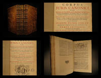
1846 1ed HUGE French ATLAS 43 MAPS Illustrated Victor Lefasseur ENORMOUS France
An absolutely enormous French atlas by Victor Levasseur!
This huge, oblong atlas contains 43 fully-illustrated maps of various regions, cities, and counties from around France each decorated with exquisite decorated borders.
Item number: #20847
Price: $795
LEVASSEUR, Victor
Atlas national illustré des 86 départements et des possessions de la France divisé par arrondissements, cantons et communes
Paris: publié par A. Combette Editeur, 1846.
Details:
· Collation: Complete with all pages;
o 43 plates of maps, plus engraved title page
· Provenance: Binding stamp – Mlle. Pauline Charuel
· Language: French
· Binding: Leather; tight and secure
· Size: ~15.25in X 22in (39cm x 56cm)
Our Guarantee:
Very Fast. Very Safe. Free Shipping Worldwide.
Customer satisfaction is our priority! Notify us with 7 days of receiving, and we will offer a full refund without reservation!
20847
Photos available upon request.
Reviews
(Log in or Create an Account first!)
Details
- Bookseller
- Schilb Antiquarian Rare Books
 (US)
(US)
- Bookseller's Inventory #
- 20847
- Title
- Atlas national illustré des 86 départements et des possessions de la France divisé par arrondissements, cantons et communes
- Author
- LEVASSEUR, Victor
- Format/Binding
- Leather; tight and secure
- Book Condition
- Used - Near Fine
- Quantity Available
- 1
- Edition
- First
- Binding
- Hardcover
- Publisher
- publié par A. Combette Editeur
- Place of Publication
- Paris
- Date Published
- 1846.
- Weight
- 0.00 lbs
- Keywords
- 1846 1ed HUGE French ATLAS 43 MAPS Illustrated Victor Lefasseur ENORMOUS France,rare, antique, old, first edition, 1st state, provenance, signed, inscribed, dust jacket, vellum, manuscript, engravings, illustrations, leather, plates, maps, antiquarian
Terms of Sale
Schilb Antiquarian Rare Books
30 day return guarantee, with full refund including original shipping costs for up to 30 days after delivery if an item arrives misdescribed or damaged.
About the Seller
Schilb Antiquarian Rare Books
Biblio member since 2018
COLUMBIA, Missouri
About Schilb Antiquarian Rare Books
We live & breathe rare books! This year we are celebrating over a decade of business with over 10,000 positive transactions all over the globe! We remain at your service and look forward to earning your business.
Glossary
Some terminology that may be used in this description includes:
- Tight
- Used to mean that the binding of a book has not been overly loosened by frequent use.
Frequently asked questions
This Book’s Categories

Collecting Vintage Valentine’s Day Cards
Exchanging Valentines can be an awkward process, especially when you consider “Vinegar Valentines” and other snarky sentiments - whatever your tastes, enjoy the sweet and sour cards alike in this gallery!

Signed vs. Inscribed
Know what you are getting into when purchasing rare books, and learn the difference between signed books and inscribed books.
Also Recommended
-

-

-
-

-

Save 10% on every purchase!
Join the Bibliophiles’ Club and start saving 10% on every book.
$29.95 / Year