Description:
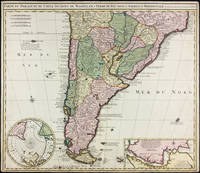
Amsterdam: Widow of Visscher, 1710. Single sheet copper engraved map, hand-colored. Margins trimmed but still quite ample, some small marginal stains, a handsome copy.. 515 x 595 mm. Strong image of the southern half of South America. Two insets: Carte particuliere de Detroit de Magellan and Circulus Antarcticus. Includes routes of the 18th c. explorers. Rodrigues 2556. Medina: Mapoteca Chilena, p.31, 10a (1740 ed).
Aerial Photographic Mosaic: Washington D.C. by School of Aerial Photographic Reconnaissance Staff - 1918
by School of Aerial Photographic Reconnaissance Staff

Aerial Photographic Mosaic: Washington D.C.
by School of Aerial Photographic Reconnaissance Staff
- Used
- good
- Paperback
School of Aerial Photographic Reconnaissance, 1918. An aerial photographic mosaic is a photographic reproduction usually made by carefully fitting together separate photos of an area so that the detail of one photograph matches the detail of all adjacent photographs. That said, this is an aerial photographic map of the city of Washington C.D. made by The School of Aerial Photographic Reconnaissance at Langley Field in Hampton, Virginia on August 17, 1918. The scale is 1 inch equaling a quarter mile. The map measures approximately 28 by 34 inches. There are a couple of repaired or reinforced tears - the largest being eight inches - all repairs are on the verso. Map does show some light creases form being rolled. Surrounding the main image of the city can be seen a thin border of the fabric/backing on which the different photos were assembled. Map will be shipped rolled. Images available. USPS tracking used on all domestic shipments. . No Edition Stated. Softcover. Good. Map.
-
Bookseller
The Bookbums at Ish Kabibble Books
 (US)
(US)
- Format/Binding Paperback
- Book Condition Used - Good
- Edition No Edition Stated
- Binding Paperback
- Publisher School of Aerial Photographic Reconnaissance
- Date Published 1918
- Keywords WASHINGTON DC | MAPS | B01DUNRMP4
More Photos
Carte du Paraguay, du Chili, Détroit de Magellan, & Terre de Feu, dans l'Amerique Meridionale par la veuve de Nicholas Visscher
by Visscher, Nicolas
- Used
- Condition
- Used - Margins trimmed but still quite ample, some small marginal stains, a handsome copy.
- Binding
- Unknown
- Quantity Available
- 1
- Seller
-
East Jewett, New York, United States
- Item Price
-
€706.88
Show Details
Item Price
€706.88
More Photos
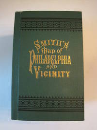
New Map of Philadelphia and Vicinity Published by J. L. Smith, 27 South Sixth St., Philadelphia, 1894 : [Cover title: Smith's Map of Philadelphia and Vicinity]
by Smith, J. L.
- Used
- Hardcover
- first
- Condition
- Used - Fine condition
- Edition
- 1st ed? (No additional printings listed)
- Binding
- Hardcover
- Quantity Available
- 1
- Seller
-
Henderson, Nevada, United States
- Item Price
-
€541.94
Show Details
Description:
Philadelphia: J. L. Smith, 1894. Fine condition. SEE PHOTOS. A very attractive, well preserved copy of this detailed two-part map of Philadelphia and vicinity, published in 1894 (copyright 1893). Tough-to-find in collectible condition as nice as this. A bright, clean copy. NO chips. NO tears. NO creases. NO owner's name or bookplate. Clean and unmarked. Drawn on a scale of 1 inch to the mile. The map consists of two parts. The eastern half unfolds to 23" wide by 27" tall. The western part is 21.5" wide by 27" tall. Both are skillfully and attractively hand colored. The maps are backed in linen, as issued. They are housed in the publisher's original, green cloth portfolio, which is printed in black and embossed in gold on the front cover and in blind on the rear. Gilt lettering is still as bright and shiny as new.. 1st ed? (No additional printings listed). Hardcover. Fine condition.
Item Price
€541.94
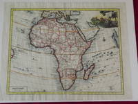
Carta Genererale dell' África.
by Delisle, Guillaume.
- Used
- Condition
- Used
- Quantity Available
- 1
- Seller
-
Florham Park, New Jersey, United States
- Item Price
-
€801.12
Show Details
Description:
Double-page hand colored engraved map, 350 x 445 mm (18" x 14", decorative cartouche. Coloring likely done at a later date, but attractively applied, wide margins, very minor aging; a bright and clear impression. Guillaume Delisle (1675-1726) was a French cartographer who was considered one of the best of his age. He has even been referred to as the father of modern geography, and was appointed Premier Geographer to Louis XV in 1718. According to Tooley and Bricker his 1700 map of Africa added a level of accuracy that would hold value for decades to come. This map of Africa is map number 84 in Norwich's Maps of Africa. The coloring was probably done at a later date, but there is an attractive cartouche with several figures, including a man spearing a crocodile. The map is from an Italian edition of Delisle’s Atlante Novissimo. Tooley & Bricker: Landmarks of Mapmaking. Norwich # 84.
Item Price
€801.12
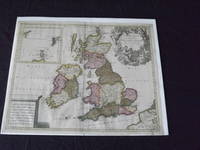
Les Isles Britanniques, qui Contiennent les Royaumes d' Angleterre, Escosse, et Irande…
by Valk, Gerard
- Used
- Condition
- Used
- Quantity Available
- 1
- Seller
-
Florham Park, New Jersey, United States
- Item Price
-
€565.50
Show Details
Description:
Copper engraved, double page, map, hand colored, cartouche uncolored, 49 x 59 cm (19 1/2" x 23"). Some minor soiling and aging; otherwise very good and quite colorful. Valk (1651-1726) was born in Amsterdam, and was also known as Valck. He was a fairly well known engraver and publisher, and would eventually go into partnership with Peter Schenk (1655-1718), and would produce an atlas and maps together. In fact, it seems they brought the property of the Blaeu firm, which gave them material for their maps. This is a very attractive map of Britain, and includes an inset of Orkney, Shetland and Faro islands. The map also contains a large cartouche that depicts angels and Poseidon. Bagrow p. 276.
Item Price
€565.50
More Photos
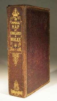
The Imperial Map of England and Wales
- Used
- very good
- Paperback
- Condition
- Used - Very Good
- Binding
- Paperback
- Quantity Available
- 1
- Seller
-
Farningham, Kent, United Kingdom
- Item Price
-
€497.03
Show Details
Description:
London & Edinburgh: A Fullarton & Co The Imperial Map of England and Wales according to the Ordnance Survey, with the latest additions shewing clearly every feature of the country, Railways and their Stations, Roads, Canals, Rivers, Gentlemens Seats etc. on the scale of 4 miles to an inch by John Bartholomew. 19 linen backed sheets numbered 1-15 plus 16 A,B and C. together with a folded index sheet. Flat sheet size, 550x750mm, folded size 275x185mm. All the maps in first class condition with no distress to folds. The folds to the paper index sheet have at some time been rather crudely stregthened. The whole enclosed in the original leathered covered box with an envelope style lid.
Item Price
€497.03

(Map of Caspian Sea & Environs): Nova et Accuratissima Maris Caspii...petri Alexii Filii. Magni Russorum Emper
by Seutter, GM
- Used
- Condition
- Used
- Binding
- Unknown
- Quantity Available
- 1
- Seller
-
Crozet, Virginia, United States
- Item Price
-
€518.38
Show Details
Description:
Augsburg: Seutter, 1740. VG+, copperplate engraving with original hand coloring (color similar to Homann, with whom Seutter apprenticed before going out on his own in about 1707). There is minimal right marginal soling, but the image and color are exceptionally bright. Decorative cartouche, as usual, probably an allegorical representation of imperial Russia. The map measures 19.25x22.5 inches. .
Item Price
€518.38

More Photos
Cartes Larousse: Atlas de la Guerre. With Directions in English, I-XLI [41 ISSUES WITH 206 PLATES. COMPLETE].
by (Cartes Larousse).
- Used
- Hardcover
- first
- Condition
- Used - .
- Edition
- 1st Edition
- Binding
- Hardcover
- Quantity Available
- 1
- Seller
-
, Netherlands
- Item Price
-
€600.00
Show Details
Description:
Paris, Librairie Larousse, (1915-19).. 1st Edition . Hardcover. .. 41 issues bound in one volume. Thick royal quarto. Unpaginated. With hundreds of letterpress maps, many of which are in colour, printed on recto only on 246 leaves of plates. Some photo-plates. Explanatory text to each map. Introductions. HARDCOVER, bound in contemporary quarter cloth, bit rubbed and scuffed in places, paper-covered boards, cloth inner hinges, spine gilt. All 41 original yellow card wrappers, printed in red, are preserved and bound-in, few with old institutional stamp; expert paper repair to one leaf with minor loss. In about fine condition. Excellent copy, very well preserved. ~ FIRST EDITION. Very rare. F-3
Item Price
€600.00

CENT VUES SUISSES remarquables par leur Situation, ou par des Faits Historiques. Dessinn�es et grav�es par Hess, Hegui [sic], K�nig, Lory, Meyer, Wetzel etc.
by Orell, F�ssli (Publishers)
- Used
- very good
- Hardcover
- Condition
- Used - Very Good
- Binding
- Hardcover
- Quantity Available
- 1
- Seller
-
Blockley, Gloucestershire, United Kingdom
- Item Price
-
€901.75
Show Details
Description:
Zurich: Orell, F�ssli et Comp., 1825 approx). Hardcover. Very Good. Copperplate engravings (100) of Swiss views and domestic scenes by Hess, Hegui, K�nig, Lory, Meyer, Wetzel and others.. Oblong octavo green morocco elaborately gilt on 4 raised bands (lacks lowest spine compartment, tips & hinges worn but sound) All Edges Gilt. Titlepage +[3]pp publisher's list +[4]pp contents + 100 plate leaves printed one side only. Clean and crisp - lovely views with a few genre scenes - wedding, peasants defending land against invaders in 1798, making cheese etc. Minor foxing almost entirely to the margins or blank back of plates, small wormhole at foot of 3 leaves. *A charming work containing views by various artists here collected together for the first time (Lonchamp 3199).
Item Price
€901.75

More Photos
GEOGRAPHIA CLASSICA Geography of the Ancients 1723: Described as it is Contained in the Greek and Latin Classics in Twenty-nine Maps of the Old World
by Herman Moll (See note)
- Used
- Hardcover
- Condition
- Used - Light discolour all prelims,initials front pastedown, ffep. Few maps minor defects,Condition Good
- Edition
- Fourth edition
- Binding
- Hardcover
- Quantity Available
- 1
- Seller
-
VICTOR HARBOR, South Australia, Australia
- Item Price
-
€589.10
Show Details
Description:
London: Christopher Brown, 1723. Fourth edition. Original Papered board covers.Front cover detached (present). Back attached.. Light discolour all prelims,initials front pastedown, ffep. Few maps minor defects,Condition Good.. Title, Preface, Advert.,Table of Maps, Twenty-nine uncoloured, copper engraved maps laid down hand made paper. (Complete as called for title page) Overalll clean, minor faults (edges, marks, folds, couple with edge tide marks, etc) Above average. Maps: World (folding - includes part of northern Australia)), Trojan War, Ulysses, Voyage of Aeneas (2), 3 world maps single page, Roman Empire (infancy, Youthful, maturity, Julius Caesar) Hannibal, Gallia Vetus (incl part of GB), Baetica, Africa, Europe/Asia/Africa, Ancient Greece, Mediterranean (Lybia), Egypt, Pyrrhus, Demetrius, Sparta, Defeat 10,000 Greeks, Syria/Assyria, Scriptual Geography, Ecclesiastical History, Cyrus the Great, Persia, Alexander. Rare cartographic publication. National Library Australia lists similar item by…
Read More Item Price
€589.10

More Photos
FL
by Wolff, Stephanie and Dorothy Simpson Krause.
- Used
- Signed
- Condition
- Used
- Edition
- Edition of 10 variants
- Binding
- Unknown
- Quantity Available
- 1
- Seller
-
Hoover, Alabama, United States
- Item Price
-
€754.00
Show Details
Description:
[Boca Raton, Florida]:: Jaffe Center for the Book Arts,, 2015.. Edition of 10 variants. 7.25 x 3.5"; 12 pages. Flutter book. Letterpress printed. Colophon with a map of Florida laser-printed. Cover and pages incorporate letterpress printing on a Vandercook 4 proof press using wood type, metal and collagraph plates. Blind printing of an area map. Printed on Arches 88 paper. Plant inclusion endpapers. Laid in handmade paper wrapper with slit-and-slot closure. Signed and numbered by the artists. Statement: "During Stephanie Wolff's residency at the Jaffe Center for Book Arts, she and Dorothy Krause, the first resident artist, collaborated on this brief ode to Florida. A variety of Pigment prints of vintage documents, maps, photographs and botanicals were transferred onto the pages of this edition of 10 variable copies.
Item Price
€754.00

More Photos
The Sky and the Forest
by Forester, C.S
- Used
- very good
- Hardcover
- first
- Condition
- Used - Very Good
- Jacket Condition
- Very Good
- Edition
- First Edition
- Binding
- Hardcover
- Quantity Available
- 1
- Seller
-
Salem, Oregon, United States
- Item Price
-
€32.88€16.45Save €17.44!
Show Details
Description:
C.S. Forester: The Sky and the Forest. Little, Brown and Company, Boston. Stated First Edition First Printing Thus August, 1948. Cover price $2.75. Used. VG BOOK/VG UNCLIPPED DUST JACKET. A story of a central Africa. By C.S. Forester, author of the Admiral Hornblower series.
Item Price
€32.88€16.45
Save €17.44
!
![Alaska and Klondike Region; [With inset of Klondike Region on the Upper Yukon detail] [From an...](https://d3525k1ryd2155.cloudfront.net/h/062/537/1339537062.0.m.jpg)
Alaska and Klondike Region; [With inset of Klondike Region on the Upper Yukon detail] [From an atlas, "Gazetteer of Alaska and Yukon Region " pp. 105 and 106]
by Miller, J. Martin
- Used
- very good
- Condition
- Used - Very Good
- Edition
- Unknown
- Quantity Available
- 1
- Seller
-
Sebastopol, California, United States
- Item Price
-
€36.76
Show Details
Description:
Chicago: J. Martin Miller, 1899. Unknown. Map. Very Good. [Map copyright 1899, printing date of Atlas later] [19.875x15.125in]; Colored map of Alaska with steamer routes from Portland and Seattle, insets of the Klondike Region on the Upper Yukon and Western portion of Aleutian Islands; On verso index of places and names with two large black and white images; Age toning to all edges, water stain marks on bottom, slight printing offset of colors, small chips and closed tears to lower edge;.
Item Price
€36.76

Zemepis Sveta - Monsunova Asie
by De La Blache, P. Vidal; Gallois, L
- Used
- Hardcover
- Condition
- Used - Very Good Condition
- Jacket Condition
- No Dust Jacket
- Binding
- Hardcover
- Quantity Available
- 1
- Seller
-
Oak Point, Texas, United States
- Item Price
-
€56.55
Show Details
Description:
Aventinum, Prague, Czechoslovakia, 1931. Hardcover. Very Good Condition/No Dust Jacket. Text entirely in Czech. Geography book on Asia with numerous photographs and maps. 1930 edition also available. Size: 4mo - over 9 3/4" - 12" tall. 400 pp. Pages are yellowed, but are tight and clean. Moderate shelfwear along the spine. Corners are lightly bumped. Quantity Available: 1. Shipped Weight: 3-5 pounds. Category: Travel & Places; Non-English Language::Czech; Pictures of this item not already displayed here available upon request. Inventory No: 001228. . Additional shipping charges may apply.
Item Price
€56.55

Last Tales
by Dinesen, Isak
- Used
- very good
- Hardcover
- first
- Condition
- Used - Very Good
- Jacket Condition
- Good+
- Edition
- First Edition
- Binding
- Hardcover
- Quantity Available
- 1
- Seller
-
Salem, Oregon, United States
- Item Price
-
€113.10€56.55Save €60.00!
Show Details
Description:
Dinesen, Isak: Last Tales, A Collection of Twelve New Tales of Compelling Beauty 1957, Random House. First Edition. Stated First Printing Thus. Used. Very Good/Good+ original red dust jacket, price-clipped. Jacket states 11/57 on front flap. 5 3/4 X
Item Price
€113.10€56.55
Save €60.00
!

Zemepis Sveta - Monsunova Asie
by De La Blache, P. Vidal; Gallois, L
- Used
- Hardcover
- Condition
- Used - Very Good Condition
- Jacket Condition
- No Dust Jacket
- Binding
- Hardcover
- Quantity Available
- 1
- Seller
-
Oak Point, Texas, United States
- Item Price
-
€56.55
Show Details
Description:
Aventinum, Prague, Czechoslovakia, 1930. Hardcover. Very Good Condition/No Dust Jacket. Text entirely in Czech. Geography book on Asia with numerous photographs and maps. 1931 edition also available. Size: 4mo - over 9 3/4" - 12" tall. 400 pp. Pages are yellowed, but are tight and clean. Moderate shelfwear along the spine. Corners are lightly bumped. Quantity Available: 1. Shipped Weight: 3-5 pounds. Category: Travel & Places; Non-English Language::Czech; Pictures of this item not already displayed here available upon request. Inventory No: 001227. . Additional shipping charges may apply.
Item Price
€56.55

The Adventure of Wrangel Island
by Vilhjalmur Stefansson
- Used
- good
- Hardcover
- first
- Condition
- Used - Good
- Jacket Condition
- No DJ Included
- Edition
- First Edition
- Binding
- Hardcover
- Quantity Available
- 1
- Seller
-
Salem, Oregon, United States
- Item Price
-
€117.71€58.86Save €62.44!
Show Details
Description:
The Adventure of Wrangel Island, Alaska (1925 Macmillan 1st Edition) HISTORY OF ALASKA. EXLIB. Good Condition/ No DJ included. Fold-out map affixed to binding at the back of the book has never been opened. The story of the (unsuccessful) attempted colonization of Wrangel Island Alaska. 413 pages plus appendix, Index. Titling is still bright. A clean, solid copy. Scarce.
Item Price
€117.71€58.86
Save €62.44
!

Seven Pillars Of Wisdom, A Triumph
by Lawrence, T.E
- Used
- good
- Hardcover
- first
- Condition
- Used - Good
- Jacket Condition
- No DJ Included
- Edition
- First American Edition
- Binding
- Hardcover
- Quantity Available
- 1
- Seller
-
Salem, Oregon, United States
- Item Price
-
€117.77€58.89Save €62.47!
Show Details
Description:
T.E. Lawrence. SEVEN PILLARS OF WISDOM, A TRIUMPH. AUTOBIOGRAPHY. Privately Printed, 1926. First Published for general circulation 1935. First American Edition. States MCMXXXVI on the title page. Doubleday, Doran & Company, Inc. Garden City, NY. GOOD CONDITION/ NO DUST JACKET IS INCLUDED. 672 pages, indexed. Beige buckram boards. Spine has darkened a bit. 6 7/8 X 9 ½.
Item Price
€117.77€58.89
Save €62.47
!

North America from the Best Authorities, Russell, ca.1800
by Russell
- Used
- Condition
- Used
- Quantity Available
- 1
- Seller
-
Plymouth, Devon, United Kingdom
- Item Price
-
€23.67
Show Details
Description:
Russell, J. : A General Map of North America from the Best Authorities. Nd but ca.1800. From "A New Geographical, Historical and Commercial Grammar and Present State of Several Kingdoms of the World." Copper engraving. Size approx 200 x 230mm. Two neat folds. Some age colouring to edges, otherwise very clean and bright.
Item Price
€23.67

Asia from the Best Authorities, Russell, ca.1800
by Russell
- Used
- Condition
- Used
- Quantity Available
- 1
- Seller
-
Plymouth, Devon, United Kingdom
- Item Price
-
€23.67
Show Details
Description:
Russell, J. : Asia from the Best Authorities. Nd but ca.1800. From "A New Geographical, Historical and Commercial Grammar and Present State of Several Kingdoms of the World". Copper engraving. Size approx 200 x 230mm. Two neat folds. Some age colouring to edges, otherwise clean and bright. Includes Arabia, India, Borneo, Japan, China and eastern Russia.
Item Price
€23.67
![MAP OF UTAH [Territory]](https://d3525k1ryd2155.cloudfront.net/h/836/461/1485461836.0.m.jpg)
More Photos
MAP OF UTAH [Territory]
- Used
- Condition
- Used - Very Good-
- Edition
- Original
- Quantity Available
- 1
- Seller
-
Williamsburg, Virginia, United States
- Item Price
-
€61.26
Show Details
Description:
New York, Richmond, Chicago, & Toledo: H. H. Hardesty, 1885. Original color lithographed map printed by Rand, McNally & Company, Engravers and published in HARDESTY'S HISTORICAL AND GEOGRAPHICAL ENCYCLOPEDIA: SPECIAL VIRGINIA EDITION. 19 3/8 inches by 13 1/4 inches on a 21" X 14 1/2" sheet. The map depicts the Territory of Utah in its final form--large areas had been removed and ceded to Nevada, Colorado, Wyoming, and Nebraska since Utah became a U. S. Territory in 1850. The issue of polygamy prevented statehood until it was finally granted in 1896. This map features railroads and topography and uses color to set off counties from each other. Unlike most atlas maps of the period, this map identifies most small towns. The map is guaranteed to be moe than 135 years old. The map is in about very good condition: generally clean and bright, with slight toning of paper and one faint water stain near the center-left edge of the map.. Original. Single Sheet. Very Good-. Elephant…
Read More Item Price
€61.26