
Click for full-size.
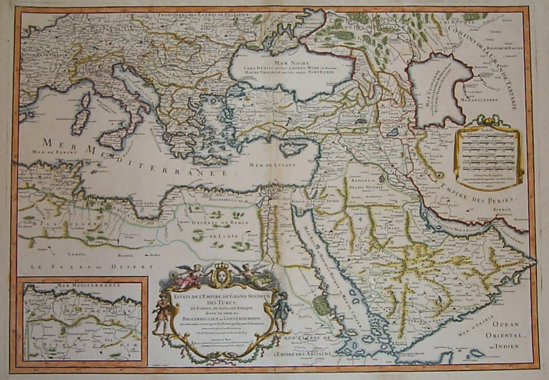
(Map / Chart- Ottoman, Turkish Empire): Estats De L'Empire Du Grand Seigneur Des Turcs, En Europe, En Asie, et En Afrique, Divise En Touts Ses Beglerbeglicz, Ou Gouvernments
by Jaillot, Alexis-Hubert
- Used
- Condition
- See description
- Seller
-
Crozet, Virginia, United States
Payment Methods Accepted
About This Item
Paris: H. Jaillot, 1695. VG, heavy paper, hand colored, decorative cartouche, inset of southern mediterranean / Algerian coast. A striking image, after Sanson and copied by several later cartographers. The above date is approximate, although clearly printed with the 5 scales indicated on the map.. Some browning and chipping of lower margin, not crossing neatline and easily covered by matting. This depicts the Ottoman (Turkish) Empire at the time, with its reaches through Asia, Europe and Africa. Includes environs of Mediterranean, Black, Red and Caspian Seas, with the "Golfe D'Ormus" at the western edge of the map. Includes details of Mediterranean with Cyprus, Rhodes, Candie, Sicily, Sardinia and Corsica, and much more. This is a very uncommon map, with the image measuring 18x25 inches (centerfold as issued)..
Reviews
On Jan 2 2024, a reader said:
H. Jaillot, Paris, 1695. VG, thick paper, colorful by hand, ornate cartouche, with an inset of the Algerian and southern Mediterranean coast. a powerful picture created by Sanson that was replicated by numerous other cartographers. The above date is an estimate, but it is printed clearly and includes the five scales that are shown on the map. Lower margin has some browning and chipping; it does not cross the neatline and is readily covered by matting. This represents the Ottoman Empire, also known as the Turkish Empire, which ruled over Asia, Europe, and Africa at the time. encompasses the areas surrounding the Mediterranean, Black, Red, and Caspian Seas, with the "Golfe D'Ormus" located at the map's western border. Features information on the Mediterranean region, including Cyprus, Rhodes, Candie, Sardinia, Sicily, Corsica, and many other places. This map, which is 18 by 25 inches, is extremely rare. I wish I can also get it on other platforms like shabd.in and kindle.
(Log in or Create an Account first!)
Details
- Bookseller
- The Prime Meridian: Antique Maps & Books
 (US)
(US)
- Bookseller's Inventory #
- 2626
- Title
- (Map / Chart- Ottoman, Turkish Empire): Estats De L'Empire Du Grand Seigneur Des Turcs, En Europe, En Asie, et En Afrique, Divise En Touts Ses Beglerbeglicz, Ou Gouvernments
- Author
- Jaillot, Alexis-Hubert
- Book Condition
- Used
- Publisher
- H. Jaillot
- Place of Publication
- Paris
- Date Published
- 1695
- Keywords
- Maps, Map, Atlas, Jaillot, Mapping, Cartography, Geography, Ottoman Empire, Turkey, Turkish Empire, Mediterranean, Red, Caspian, Black, Sea, Middle East, Fr
- Bookseller catalogs
- D. Maps--General;
Terms of Sale
The Prime Meridian: Antique Maps & Books
We accept cash, check, money order, American Express, Visa, Discover and Mastercard. Virginia sales tax will be added to instate purchases. Shipping charges are billed at cost, and will be added to the invoice. We usually include insurance with the postage, and as a result we do not routinely use media mail. If you wish the book sent via the latter route, it would be at your risk. For heavy items, there may be extra shipping charges. Any item maybe returned (postpaid and carefully packed by purchaser) within 7 days of receipt. We do not generally refund postal charges. Please notify us before sending a return. We do not share customer information with any outside sources; all details and addresses are confidential.
About the Seller
The Prime Meridian: Antique Maps & Books
Biblio member since 2005
Crozet, Virginia
About The Prime Meridian: Antique Maps & Books
The Prime Meridian: Antique Maps & Books is owned and operated by Joel & Deborah Kovarsky. We first opened in 1998, but have had a decades-old interest in old maps, books, and paper, stemming from a comparable long-standing interest in how knowledge is used. Our business is run via the internet. We do not run an open shop, however we do welcome visitors by appointment only. Before attempting a visit, please contact us. We are a specialty business, dealing in antiquarian maps and related books (atlases, history of cartography, selected reference books, etc.). Please feel free to contact us for specific inquiries.
Glossary
Some terminology that may be used in this description includes:
This Book’s Categories

Collecting the Harlem Renaissance
One of the most influential - and certainly most iconic - cultural revolutions in American history, the Harlem Renaissance offers a compelling repertoire for both seasoned and novice book collectors. We’ve put together a beautiful gallery of high points to help start your collection here.

Handling and Storing Books
Take care of your old books — vintage, antiquarian, and fine — with these tips from a professional bookseller
Also Recommended
-

-

-

-

-

Save 10% on every purchase!
Join the Bibliophiles’ Club and start saving 10% on every book.
$29.95 / Year